A roundabout is a type of round (about) intersection or junction in which road traffic is permitted to flow in one direction around a central island, and priority is typically given to traffic already in the junction.

An intersection is an at-grade junction where two or more roads converge, diverge, meet or cross. Major intersections are often delineated by gores and may be classified by road segments, traffic controls and lane design.
Highway 19, is the main north-south thoroughfare on Vancouver Island from Nanaimo to Port Hardy. A highway has existed on the Island since about 1912. Originally gravel and rough, the highway was an essential link together with the Esquimalt & Nanaimo Railway. The paved highway first opened in 1953, replacing a stretch of Highway 1 between Nanaimo and Campbell River, finally being extended to the northern tip of the island in the late 1970s. The total length of the highway is 403 kilometres (250 mi).
Highway 1 is the main route of the Trans-Canada Highway (TCH) through British Columbia, Canada. Its total accumulated distance through British Columbia is 1,039 km (646 mi), including the distance travelled on ferries. It is the westernmost portion of the "Highway 1" designation of the TCH through Western Canada, which extends to the Manitoba–Ontario boundary. The section of Highway 1 in the Lower Mainland is the second-busiest freeway in Canada, after the section of Ontario Highway 401 in Toronto.

The Isle of Wight Steam Railway is a heritage railway on the Isle of Wight. The railway passes through 5+1⁄2 miles (9 km) of countryside from Smallbrook Junction to Wootton station, passing through the small village of Havenstreet, where the line has a station, headquarters and a depot. At Smallbrook Junction, the steam railway connects with the Island Line.
Switch Island is a major road junction near Aintree in Merseyside, England in the Metropolitan Borough of Sefton. The junction is at the western terminus of both the M57 and M58 motorways, which converge on the A59 trunk road, the north-south route from Liverpool. The junction is also the terminus of the A5036, a road which serves the Port of Liverpool, and the A5758 which serves as a bypass for the village of Thornton.

The Parish of Saint Peter is one of eleven parishes in the Caribbean island country of Barbados. It is named after the Christian Apostle and patron saint, Saint Peter. It is located in the north of Barbados, and is the only parish besides Saint Lucy that extends from the east coast to the west.
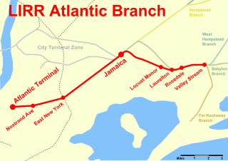
The Atlantic Branch is an electrified rail line owned and operated by the Long Island Rail Road in the U.S. state of New York. It is the only LIRR line that runs in the borough of Brooklyn.

The A4540 is a Ring Road in Birmingham, England, also known as the Middle Ring Road, or the Middleway. There are proposals to make it a red route. It runs around the centre of the city at a distance of approximately 1 mile (1.6 km). Birmingham City Centre is the area within this ring road. The ring road was planned and designed by Herbert Manzoni. It is now simply known as the Ring Road due to the removal of the old Inner Ring Road.

Queen's Road East is a street in Wan Chai, in the north of Hong Kong Island, Hong Kong, connecting Admiralty in the west to Happy Valley in the east. Queen's Road East is one of the four sections of Queen's Road, and historically included Queensway.
A junction is where two or more roads meet.

Copiague is a station on the Babylon Branch of the Long Island Rail Road, located in Copiague, New York. The station is located on Marconi Boulevard and Great Neck Road, one block north of Oak Street.
New York State Route 107 (NY 107) is a 17.07-mile (27.47 km) state highway in Nassau County, New York, in the United States. The route begins at an intersection with Merrick Road in Massapequa, serving several communities in the town of Oyster Bay before entering the city of Glen Cove and terminating at an intersection with Pulaski Street. From here, the right-of-way continues west for a short distance as Pratt Boulevard (CR 243) to Brewster Street and Glen Cove Avenue. Route 107 is the only State Highway on Long Island to enter a city other than New York City. The route connects with several major parkways and expressways and has a concurrency with NY 106 through Hicksville and Jericho Gardens.

The A444 is a primary road running between Coventry and Burton upon Trent in England, usually referred to as the "A treble four" or "A triple four".

The Whitestone Branch was a branch of the Long Island Rail Road, running north and east along the left bank of the Flushing River from the Port Washington Branch near the modern Willets Point/Flushing sections of Queens, New York. It crossed the river on one of the three bridges that were later torn down for the Van Wyck Expressway, then ran north along Flushing Bay and east along the East River to Whitestone.

Hillside was a junction and station on the Long Island Rail Road's Main Line and Montauk Branch in Hillside, Queens, New York City, United States. It was located east of where the Montauk Branch now crosses over the two eastbound passenger tracks and the two freight tracks of the Main Line, just west of the Hillside Facility.

U.S. Route 1 in Rhode Island is a major north–south state highway through the U.S. state, specifically within the Providence metropolitan area. Staying close to the Atlantic Ocean and Narragansett Bay, it is a longer route than Interstate 95, and many portions are a four-lane divided highway.

Fresh Pond was a Long Island Rail Road station along the Lower Montauk Branch, located on an open cut near Fresh Pond Road and Metropolitan Avenue in Fresh Pond, Queens, on the border between the neighborhoods of Maspeth and Ridgewood.

National Highway 966A or NH 966A starts at Kalamassery and ends at Vallarpadam International Container Transhipment Terminal in Kochi, Kerala, India. The total length of the highway is 15 km (9.3 mi) and runs only inside Kochi.
Longbridge Interchange is a major road and motorway junction between Warwick and Sherbourne, Warwickshire, connecting the A46 road and A429 road respectively to the M40 motorway at junction 15. For many years, it was deemed inadequate in handling the volume of traffic, which in 2009 was estimated to be in the region of 75,000 vehicles daily; a bypass was built during 2008-2009 which relieved congestion.
