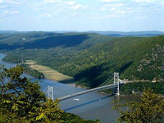
Rensselaerville is a town in Albany County, New York, United States. The population was 1,843 at the 2010 census. The town is named after Stephen Van Rensselaer. The "official" hamlets are Cooksburg, Medusa, Potter Hollow, Preston Hollow, and Rensselaerville.

The Mohawk River is a 149-mile-long (240 km) river in the U.S. state of New York. It is the largest tributary of the Hudson River. The Mohawk flows into the Hudson in Cohoes, New York, a few miles north of the city of Albany. The river is named for the Mohawk Nation of the Iroquois Confederacy. It is a major waterway in north-central New York.

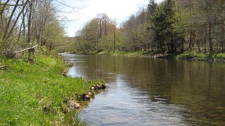
The Beaver Kill, sometimes written as the Beaverkill or Beaverkill River, is a tributary of the East Branch Delaware River, a main tributary of the Delaware River, approximately 44 miles (71 km) long, in the U.S. State of New York. The kill drains a 300-square-mile (780 km2) area of the Catskill Mountains and has long been celebrated as one of the most famous trout streams in the United States. Its preservation helped establish many of the basic conservation principles of rivers in the United States.

Schoharie Creek in New York, flows north 93 miles (150 km) from the foot of Indian Head Mountain in the Catskills through the Schoharie Valley to the Mohawk River. It is twice impounded north of Prattsville to create New York City's Schoharie Reservoir and the Blenheim-Gilboa Power Project.

Stony Clove Creek is a 10.3-mile-long (16.6 km) creek in the Catskill Mountains in New York. It is a tributary of Esopus Creek, which in turn is a tributary of the Hudson River. It joins the Esopus in the village of Phoenicia, and has two smaller tributaries up north of Phoenicia.

Thomas Cole Mountain is a mountain located in Greene County, New York. The mountain named for Thomas Cole (1801–1848), an artist who lived in the area, and is regarded as the founder of the Hudson River School.
Windham High Peak is a mountain located in Greene County, New York. The mountain is part of the Catskill Mountains.
North Dome is a mountain located in Greene County, New York. The mountain is part of the Catskill Mountains. North Dome is flanked to the east by West Kill Mountain, and to the west faces Mount Sherrill.

Peekamoose Mountain is a mountain located in Ulster County, New York. The mountain is part of the Catskill Mountains. Peekamoose Mountain is flanked to the north by Table Mountain. The name Peekamoose is possibly a corruption of an Algonquin word meaning 'broken off smooth', cf. Poke-O-Moonshine Mountain.

Willowemoc Creek is a tributary of Beaver Kill. It is a popular trout fishing stream near the Catskill Park in Sullivan County, New York.
Tenmile Creek is a 15.0-mile-long (24.1 km) tributary of Catskill Creek in Albany County, New York. Via Catskill Creek, it is part of the Hudson River watershed.
Eightmile Creek is an 11.8-mile-long (19.0 km) tributary of Tenmile Creek in Albany County, New York. Via Tenmile Creek and Catskill Creek, it is part of the Hudson River watershed. Eightmile Creek runs through the town of Westerlo into the town of Rensselaerville, where it joins Tenmile Creek at the hamlet of Medusa. The creek's source is near Onderdonk Lake by Snyders Corners in Westerlo.
Lake Creek is a 5.8-mile-long (9.3 km) tributary of Catskill Creek in Albany and Schoharie counties, New York, in the United States. Via Catskill Creek, it is part of the Hudson River watershed. Lake Creek runs from the Rensselaerville State Forest in the town of Rensselaerville to Catskill Creek at Livingstonville in the town of Broome.
Bowery Creek is a 6.0-mile-long (9.7 km) tributary of Catskill Creek north of the Catskill Mountains of New York. Via Catskill Creek, it is part of the Hudson River watershed. Bowery Creek rises east of Windham High Peak in the northern part of the town of Cairo and flows northeast to Catskill Creek west of Freehold.
Franklinton Vlaie or "The Vlaie" is a tributary of Catskill Creek in Broome, Schoharie County, New York in the United States.
Jan de Bakker's Kill is a 7.1-mile-long (11.4 km) tributary of Catskill Creek, part of the Hudson River watershed, in the Catskill Mountains of New York.
Potic Creek is a 10.1-mile-long (16.3 km) tributary to Catskill Creek in the Catskill Mountains of New York. The name comes from the Mahican for a waterfall, originally referring to the falls in the Catskill near Wolcott Mills. Potic also originally referred to the name of the American Indian village below the falls and also of the commanding hill north of the falls.
Kaaterskill Creek is a 25.9-mile-long (41.7 km) tributary of Catskill Creek in Greene and Ulster counties in New York. Via Catskill Creek, it is part of the Hudson River watershed.

The West Kill, an 11-mile-long (18 km) tributary of Schoharie Creek, flows across the town of Lexington, New York, United States, from its source on Hunter Mountain, the second-highest peak of the Catskills. Ultimately its waters reach the Hudson River via the Mohawk. Since it drains into the Schoharie upstream of Schoharie Reservoir, it is part of the New York City water supply system. It lends its name to both a mountain to its south and a small town midway along its length.


