Fraulautern

Last updated
Fraulautern
Stadtteil of Saarlouis
Fraulautern Kirche pano.jpg
The Dreifaltigkeitskirche Church
Fraulauterner Wappen.jpg
Coat of arms
Location of Fraulautern
Fraulautern
Germany adm location map.svg
Red pog.svg
Fraulautern
Saarland location map 02.svg
Red pog.svg
Fraulautern
Coordinates: Coordinates: 49°19′40″N6°46′15″E / 49.32778°N 6.77083°E / 49.32778; 6.77083
Country Germany
State Saarland
District Saarlouis
Town Saarlouis
Population
 (2017-06-30)
  Total7,000
Time zone UTC+01:00 (CET)
  Summer (DST) UTC+02:00 (CEST)
Postal codes
66740
Dialling codes 06831
Vehicle registration SLS
Website www.fraulautern.net

Fraulautern is a district of Saarlouis in the Saarland region of Germany. In 1936, the village of Fraulautern was incorporated into the city of Saarlouis. It is also the source of the alternative name for Saarlouis, Saarlautern. Fraulautern has approximately 7000 inhabitants.

Contents

Location

Although the city of Saarlouis proper is situated on the left side of the Saar, the district of Fraulautern (along with the districts of Roden and Steinrausch) are found on the river's right bank. Fraulautern borders the former coal-mining facility of the neighboring community of Ensdorf.

History

Since the middle of the 12th century, a place known as "Lutrea Wilrea" was recorded as being the home of a settlement of either cannons or monks. From this settlement arose the Fraulautern Abbey, a Stift made up of noble Augustinian nuns.

The name "Fraulautern" comes from both the inhabitants of the cloister as well as the celtic word "Lutra" meaning "swampy stream" - a reference here to Fraulautern's location at the junction of the Fraulautern Bach into the Saar.

The first seal of the cloister bore the symbol of the Holy Trinity – the patron saint of the cloister. From 1581, the cloister belonged to the Duchy of Lorraine, however, the town successfully contended for Imperial immediacy in the Holy Roman Empire before the Reichskammergericht on account of its holdings in Schwarzenholz. Between 1795 and 1815, it was part of the Département Moselle (Canton of Saarlouis).

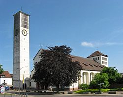
In 1540, the present-day Appollonia-Kapelle was consecrated as a parish church. In 1814, however, the cloister church from 1739 took over the parish church function. The decision to build a new parish church occurred in 1884 followed eventually by the laying of the cornerstone in 1893 and the consecration of the new building in 1895.

The first train station within the boundaries of present-day Saarlouis was opened in Fraulautern on December 16, 1858 in the course of the construction of the Saar Railway. The move of the Saarlouis Central Train Station to its present location in Roden occurred on December 19, 1912.

On December 1, 1944, air raids destroyed large portions of Fraulautern, including the parish church and the Apollonia-Kapelle. After the cornerstone was laid for current church, the Church of the Holiest Trinity, was consecrated on November 16, 1960 by auxiliary bishop Bernhard Stein.

Local Dialect

The local dialect in Saarlouis belongs to the Moselle Franconian/Saarlandish group of dialects.

Sources

Related Research Articles

Saarland State of Germany

Saarland is a state of Germany in the west of the country. With an area of 2,570 km2 (990 sq mi) and population of 995,600 in 2015, it is the smallest German state in both area and population apart from the city-states of Berlin, Bremen, and Hamburg. Saarbrücken is the state capital and largest city; other cities include Neunkirchen and Saarlouis. Saarland is mainly surrounded by the department of Moselle in France to the west and south and the neighboring state of Rhineland-Palatinate in Germany to the north and east; it also shares a small border about 8 kilometres long with the canton of Remich in Luxembourg to the northwest.

Moselle (department) Department of France

Moselle is the most populous department in Lorraine, in the east of France, and is named after the river Moselle, a tributary of the Rhine, which flows through the western part of the department. Inhabitants of the department are known as Mosellans.

Saarlouis is a Kreis (district) in the middle of the Saarland, Germany. Neighboring districts are Merzig-Wadern, Sankt Wendel, Neunkirchen, Saarbrücken, and the French département Moselle.

Saarlouis Place in Saarland, Germany

Saarlouis is a town in Saarland, Germany, capital of the district of Saarlouis. In 2017, the town had a population of 34,758. Saarlouis, as the name implies, is located on the river Saar. It was built as a fortress in 1680 and named after Louis XIV of France.

Rödermark Place in Hesse, Germany

Rödermark is a town in the Offenbach district in the Regierungsbezirk of Darmstadt in Hesse, Germany, southeast of Frankfurt am Main and northeast of Darmstadt.

Rodgau Place in Hesse, Germany

Rodgau is a town in the Offenbach district in the Regierungsbezirk of Darmstadt in Hesse, Germany. It lies southeast of Frankfurt am Main in the Frankfurt Rhine Main Region and has the greatest population of any municipality in the Offenbach district. It came into being in 1979 when the greater community of Rodgau was raised to town, after having been formed through a merger of five formerly self-administering communities in the framework of municipal reform in Hesse in 1977. The current constituent communities’ history reaches back to the 8th century.

Cochem Place in Rhineland-Palatinate, Germany

Cochem is the seat of and the biggest town in the Cochem-Zell district in Rhineland-Palatinate, Germany. With just over 5,000 inhabitants, Cochem falls just behind Kusel, in the Kusel district, as Germany's second smallest district seat. Since 7 June 2009, it has belonged to the Verbandsgemeinde of Cochem.

Kelso, New South Wales Town in New South Wales, Australia

Kelso is a suburb of Bathurst, New South Wales, Australia, in the Bathurst Regional Council area.

Dillingen, Saarland Place in Saarland, Germany

Dillingen is a town in the district of Saarlouis, in Saarland. It has about 20,000 inhabitants and is divided into the three districts Dillingen-city center, Pachten and Diefflen. The city is located on the edge of the Saar-Hunsrück Nature Park at the mouth of the Prims in the Saar and is located about 10 km from the French border. Dillingen is located about 60 km from Luxembourg City and Trier, 50 km from Metz and 30 km from Saarbrücken and is directly adjacent to the urban area of Saarlouis. In terms of population, it is the second largest municipality in the district of Saarlouis. The Dillinger Hütte steelworks is located here.

Merzig Place in Saarland, Germany

Merzig is a town in Saarland, Germany. Is is the capital of the district Merzig-Wadern, with about 30,000 inhabitants in 17 municipalities on 108 km². It is situated on the river Saar, approx. 35 km south of Trier, and 35 km northwest of Saarbrücken.

Einöd District of Homburg in Saarland, Germany

The village of Einöd, in the local dialect Ehnedd, is a municipal district of the town Homburg. It is part of the Saar-Palatinate County and located in the State of Saarland. It includes three municipal fractions: Einöd, Ingweiler and Schwarzenacker. The first documented mention of Einöd was made in 1290 CE. In 2019, the centrally located village had 3.351 inhabitants.

Ehingen Place in Baden-Württemberg, Germany

Ehingen (Donau) is a town in the Alb-Donau district in Baden-Württemberg, Germany, situated on the left bank of the Danube, approx. 25 kilometres southwest of Ulm and 67 km (42 mi) southeast of Stuttgart.

Petite-Rosselle Commune in Grand Est, France

Petite-Rosselle is a commune in the Moselle department of the Grand Est region in north-eastern France. The commune is separated from neighbouring Großrosseln by the river Saar, which forms the border between France and Germany. It has 6,785 inhabitants.

Leudwinus

Saint Leudwinus, Count of Treves founded an abbey in Mettlach. He was Archbishop of Treves and Laon. As patron saint of the Mettlach parish, his relics are carried through the town by procession at the annual Pentecost celebration. His feast day is September 23. He was the son of Saint Warinus, the paternal grandson of Saint Sigrada, and nephew of Saint Leodegarius.

Dommershausen Place in Rhineland-Palatinate, Germany

Dommershausen is an Ortsgemeinde – a municipality belonging to a Verbandsgemeinde, a kind of collective municipality – in the Rhein-Hunsrück-Kreis (district) in Rhineland-Palatinate, Germany. It belongs to the Verbandsgemeinde of Kastellaun, whose seat is in the like-named town.

Korweiler Place in Rhineland-Palatinate, Germany

Korweiler is an Ortsgemeinde – a municipality belonging to a Verbandsgemeinde, a kind of collective municipality – in the Rhein-Hunsrück-Kreis (district) in Rhineland-Palatinate, Germany. It belongs to the Verbandsgemeinde of Kastellaun, whose seat is in the like-named town.

Saar Railway Railway in Germany

The Saarbrücken–Trier railway, known in German as the Saarstrecke in the German states of Rhineland-Palatinate and Saarland. It connects Saarbrücken and Trier. It was opened in 1858 and 1860 and is one of the oldest railways in Germany.

Saarlouis Hauptbahnhof

Saarlouis Hauptbahnhof is the only station in the town of Saarlouis in the German state of Saarland. It is on the Saar line between Trier and Saarbrucken in the district of Roden, about 1 km north of the city centre. It is classified by Deutsche Bahn as a category 3 station.

Diefflen Stadtteil of Dillingen/Saar in Saarland, Germany

Diefflen is a district of Dillingen/Saar in the district of Saarlouis (Saarland) and has about 4700 inhabitants. It is located on the lower Prims, a tributary of the Saar. Since its foundation in the High Middle Ages Diefflen was historically linked to the villages of the former "Hochgericht Nalbacher Tal". This association was broken when Diefflen was incorporated into the city of Dillingen/Saar in 1969.

Schwarzenholz

Schwarzenholz is the second largest district of the municipality of Saarwellingen in Saarland, Germany.