| Frenchman Lake | |
|---|---|
 Frenchman Lake | |
| Location | Yukon |
| Coordinates | 62°10′N135°50′W / 62.167°N 135.833°W |
| Basin countries | Canada |
Frenchman Lake is a lake located in Carmacks, Yukon, Canada. [1]
| Frenchman Lake | |
|---|---|
| Frenchman Lake | |
| Location | Yukon |
| Coordinates | 62°10′N135°50′W / 62.167°N 135.833°W |
| Basin countries | Canada |
Frenchman Lake is a lake located in Carmacks, Yukon, Canada. [1]
A Frenchman is a French person.
The Battle of Frenchman's Butte, fought on May 28, 1885, occurred when a force of Cree, dug in on a hillside near Frenchman's Butte, was unsuccessfully attacked by the Alberta Field Force. It was fought in what was then the District of Saskatchewan of the North-West Territories.

Frenchmans Cap is a mountain in the West Coast region of Tasmania, Australia. The mountain is situated in the Franklin-Gordon Wild Rivers National Park.

Division No. 17 is one of eighteen census divisions in the province of Saskatchewan, Canada, as defined by Statistics Canada. It is located in the west-northwest part of the province, bordering Alberta. The most populous community in this division is the interprovincial city of Lloydminster. Another important population centre is the town of Meadow Lake.

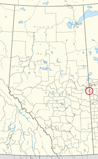
The Rural Municipality of Frenchman Butte No. 501 is a rural municipality (RM) in the Canadian province of Saskatchewan within Census Division No. 17 and SARM Division No. 6.
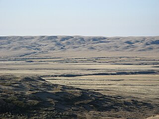
The Frenchman Formation is stratigraphic unit of Late Cretaceous age in the Western Canada Sedimentary Basin. It is present in southern Saskatchewan and the Cypress Hills of southeastern Alberta. The formation was defined by G.M. Furnival in 1942 from observations of outcrops along the Frenchman River, between Ravenscrag and Highway 37. It contains the youngest of dinosaur genera, much like the Hell Creek Formation in the United States.

The Rural Municipality of Val Marie No. 17 is a rural municipality (RM) in the Canadian province of Saskatchewan within Census Division No. 4 and SARM Division No. 3. Located in the southwest portion of the province, it is adjacent to the Canada–United States border, neighbouring Phillips County in Montana.

Frenchman's Cove is a town on the west coast of Burin Peninsula, Newfoundland and Labrador, Canada. It had a population of 159 in the Canada 2021 Census, a drop from 172 in 2011. The town has been inhabited since before 1836, the earliest known documentation about it, when it appeared in the first Newfoundland Census. According to local folklore and tradition, the first settlers were named Cleuetts and were of French origin. The small-boat inshore fishery was the economic mainstay of the area until the late 1800s when did men went work on the schooners operating from Grand Bank. Residents also grew turnips, cabbages, and potatoes, as well as hay for their horses, cattle, sheep, and chickens.
Frenchman Butte is a butte located 45 km northeast of Lloydminster, is named after a Frenchman who was killed there by Indians in the 19th century. It is not known how or why this man was murdered. This was also the site of the Battle of Frenchman's Butte between Major-General Thomas Bland Strange and Cree Chief Big Bear.

The Onion Lake Cree Nation is a Plains Cree First Nations band government in Canada, straddling the Alberta/Saskatchewan provincial border approximately 50 km (31 mi) north of the City of Lloydminster.
Frenchman Lake is a lake of Halifax Regional Municipality, Nova Scotia, Canada in the community of Dartmouth.
The Frenchman River,, also known locally as the Whitemud River, is a river in Saskatchewan, Canada and Montana, United States. It is a tributary of the Milk River, itself a tributary of the Missouri and in turn a part of the Mississippi River watershed that flows to the Gulf of Mexico.
Makaoo 120 is an Indian reserve of the Onion Lake Cree Nation in Alberta and Saskatchewan, located between the County of Vermilion River and the Rural Municipality of Frenchman Butte No. 501. It is 42 kilometres north of Lloydminster. In the 2016 Canadian Census, it recorded a population of 726 living in 165 of its 179 total private dwellings.
Frenchman's Cove Provincial Park, is a provincial park located on the west side of the Burin Peninsula in Newfoundland and Labrador, Canada.
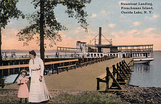
Frenchman Island is a 26-acre (11 ha) island located in Oneida Lake in Oswego County, New York, United States. It was known historically as "Seven Mile Island" during the American Revolution and by the Onondaga people as Kah-wha-nah-kee.

Route 213 is a highway on the Burin Peninsula of the island of Newfoundland in the Canadian province of Newfoundland and Labrador. It is one of a small number of provincial routes that start and end on the same highway. It is a very short route, running for about 12 kilometres. Due to being a rough road, the maximum speed limit is 60 km/h, except through communities where the speed limit is reduced to 30 km/h. The western side of the route allows for a drive along the shore of Fortune Bay, until reaching the community of Frenchman's Cove. Midway along the route is Frenchman's Cove Provincial Park, one of only a small number of provincial parks in existence since 1997. After exiting Frenchman's Cove, motorists travel along the Frenchman's Cove Barasway and enjoy more of a view of Fortune Bay until approaching the Town of Garnish.
Cypress Lake is an interbasin transfer reservoir in the Canadian province of Saskatchewan on the southern slopes of the Cypress Hills in the Rural Municipality of Reno No. 51. The reservoir was created by the damming of the east and west sides of a much smaller Cypress Lake in the late 1930s. There is a provincial recreation site on the southern shore and a wildlife refuge on Heglund Island in the lake. Access to the lake is from Township Road 60 off of Highway 21.
| | This article about a Yukon location is a stub. You can help Wikipedia by expanding it. |
| | This article related to a lake in Canada is a stub. You can help Wikipedia by expanding it. |