
Bakewell is a market town and civil parish in the Derbyshire Dales district of Derbyshire, England, known for Bakewell pudding. It lies on the River Wye, 15 miles (23 km) south-west of Sheffield. It is the largest settlement and only town within the boundaries of the Peak District National Park. At the 2011 census, the population of the civil parish was 3,949. It was estimated at 3,695 in 2019. The town is close to the tourist attractions of Chatsworth House and Haddon Hall.
Mickleover is a village in the unitary authority of Derby, in Derbyshire, England. It is 2 miles (3.2 km) west of Derby, 10 miles (16 km) northeast of Burton upon Trent, 13 miles (21 km) southeast of Ashbourne and 12 miles (19 km) northeast of Uttoxeter.
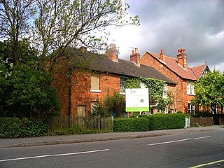
Egginton is a village and civil parish in the local government district of South Derbyshire, England. The population of the civil parish as of the 2011 census was 574.

The Limestone Way is a waymarked long-distance footpath in Derbyshire, England. It runs for 46 miles (74 km) through the White Peak of the Peak District National Park, from Castleton south to Rocester over the county boundary into Staffordshire. The trail is named for the limestone scenery along its route. It was devised by Brian Spencer of Matlock Rotary Club and developed and opened in 1986 by the West Derbyshire District Council. It originally ran to Matlock, but was extended to its current, longer route in 1992 to join up with the Staffordshire Way.

"Underneath the Arches" is a 1932 popular song with words and music by Bud Flanagan, and additional lyrics by Reg Connelly. It was one of the most famous songs of the duo Flanagan and Allen.
The Derbyshire and Staffordshire extension of the Great Northern Railway was an English railway network built by the GNR to get access to coal resources in the area to the north and west of Nottingham. The Midland Railway had obstructed the GNR in its attempts to secure a share of the lucrative business of transporting coal from the area, and in frustration the GNR built the line. The line was forked: it reached Pinxton in 1875 and a junction with the North Staffordshire Railway at Egginton, approaching Burton on Trent in 1878. The line cut through Derby, resulting in considerable demolition of housing there.

Derby Friargate railway station was the main station in Derby on the Great Northern Railway Derbyshire Extension, popularly known as the (Derby) Friargate Line.
Andrew Handyside and Company was an iron founder in Derby, England, in the nineteenth century.
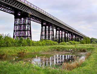
Bennerley Viaduct is a former railway bridge, now a foot and cycle bridge, between Ilkeston, Derbyshire, and Awsworth, Nottinghamshire, in central England. It was completed in 1877 and carried the Great Northern Railway's (GNR) Derbyshire Extension over the River Erewash, which forms the county boundary, and its wide, flat valley. The engineer was Samuel Abbott, who worked under Richard Johnson, the GNR's chief engineer. The site required a bespoke design as the ground would not support a traditional masonry viaduct due to extensive coal mining. The viaduct consists of 16 spans of wrought iron, lattice truss girders, carried on 15 wrought iron piers which are not fixed to the ground but are supported by brick and ashlar bases. The viaduct is 60 feet high, 26 feet wide between the parapets, and over a quarter of a mile long. It was once part of a chain of bridges and embankments carrying the railway for around two miles across the valley but most of its supporting structures were demolished when the line closed in 1968. The only similar surviving bridge in the United Kingdom is Meldon Viaduct in Devon.

Outwood Viaduct is a Grade II listed railway viaduct crossing the River Irwell in Radcliffe, Greater Manchester. Following a period of disuse, it was restored and opened to the general public as a footpath.
Awsworth railway station was a former railway station in Awsworth, Nottinghamshire. It was opened by the Great Northern Railway on its Derbyshire and Staffordshire Extension in 1875–6.

Egginton Junction railway station is a disused railway station in Egginton, Derbyshire.
Henry Isaac Stevens FRIBA was an architect based in Derby. He was born in London, in 1806, and died in 1873. In the late 1850s he changed his name to Isaac Henry Stevens.

Derby Dominican Priory, also known as Derby Black Friary, or Blackfriars, Derby, was a Dominican priory situated in the town of Derby, England. It was also named in different sources as a friary, monastery and convent, but was officially a priory as it was headed by a prior and the Dominican Order calls all their houses Priories. The "Black" came from the colour of the mantles worn by the friars of the order.

Handyside Bridge, also known as Derwent Bridge, is a former railway bridge in Darley Abbey, Derbyshire, England which was converted to a foot bridge in 1976 following closure of the railway in 1968.

Richard Johnson, MICE was a British railway engineer, latterly chief engineer for the Great Northern Railway (GNR).

John Holloway Sanders FRIBA was an architect based in England and chief architect of the Midland Railway until 1884.

Bolehall Viaduct, known locally as The 19 Arches is a 807 feet (246 m) viaduct on the former Birmingham and Derby Junction Railway line near Tamworth, Staffordshire, England now part of the Cross Country Route.
The area to the north and northwest of the centre of the city of Derby, England, contains 76 listed buildings that are recorded in the National Heritage List for England. Of these, three are listed at Grade I, the highest of the three grades, ten are at Grade II*, the middle grade, and the others are at Grade II, the lowest grade. The area is largely residential, and it contains some industry, mainly in former silk mills, and the Midland Railway had a goods yard in the area. Most of the listed buildings are houses and associated structures. Some of the former mills are listed, together with buildings in the Midland Railway goods yard. The other listed buildings include churches and chapels, public houses and a hotel, shops, bridges, the remains of a cross, a well, a convent, street bollards, war memorials and a telephone kiosk.

