Friedrichswalde

Last updated
Friedrichswalde
Location of Friedrichswalde within Barnim district
Friedrichswalde in BAR.pngBritzJoachimsthalMarienwerderSchorfheideZiethen
Germany adm location map.svg
Red pog.svg
Friedrichswalde
Brandenburg location map.svg
Red pog.svg
Friedrichswalde
Coordinates: 53°02′N13°43′E / 53.033°N 13.717°E / 53.033; 13.717
Country Germany
State Brandenburg
District Barnim
Municipal assoc. Joachimsthal (Schorfheide)
Subdivisions2 Ortsteile
Government
   Mayor (201924) Bernhard Ströbele [1] (Ind.)
Area
  Total44.89 km2 (17.33 sq mi)
Elevation
75 m (246 ft)
Population
 (2021-12-31) [2]
  Total808
  Density18/km2 (47/sq mi)
Time zone UTC+01:00 (CET)
  Summer (DST) UTC+02:00 (CEST)
Postal codes
16247
Dialling codes 033367
Vehicle registration BAR
Website www.amt-joachimsthal.de

Friedrichswalde is a municipality in the district of Barnim in Brandenburg in Germany. It is situated in the Schorfheide nature reserve.

Contents

History

From 1815 to 1947, Friedrichswalde was part of the Prussian Province of Brandenburg, from 1947 to 1952 of the State of Brandenburg, from 1952 to 1990 of the East German Bezirk Frankfurt and since 1990 again of Brandenburg.

Demography

Development of population since 1875 within the current boundaries (Blue line: Population; Dotted line: Comparison to population development of Brandenburg state; Grey background: Time of Nazi rule; Red background: Time of communist rule) Bevolkerungsentwicklung Friedrichswalde.pdf
Development of population since 1875 within the current boundaries (Blue line: Population; Dotted line: Comparison to population development of Brandenburg state; Grey background: Time of Nazi rule; Red background: Time of communist rule)
Friedrichswalde: Population development
within the current boundaries (2020) [3]
YearPop.±% p.a.
1875 1,389    
1890 1,332−0.28%
1910 1,428+0.35%
1925 1,481+0.24%
1933 1,396−0.74%
1939 1,338−0.70%
1946 1,733+3.76%
1950 1,839+1.50%
1964 1,374−2.06%
1971 1,278−1.03%
1981 1,086−1.61%
1985 1,033−1.24%
1989 1,006−0.66%
1990 970−3.58%
1991 965−0.52%
YearPop.±% p.a.
1992 996+3.21%
1993 901−9.54%
1994 920+2.11%
1995 912−0.87%
1996 908−0.44%
1997 890−1.98%
1998 903+1.46%
1999 954+5.65%
2000 944−1.05%
2001 950+0.64%
2002 944−0.63%
2003 941−0.32%
2004 963+2.34%
2005 965+0.21%
2006 940−2.59%
YearPop.±% p.a.
2007 902−4.04%
2008 894−0.89%
2009 895+0.11%
2010 888−0.78%
2011 839−5.52%
2012 844+0.60%
2013 824−2.37%
2014 809−1.82%
2015 807−0.25%
2016 801−0.74%
2017 803+0.25%
2018 795−1.00%
2019 803+1.01%
2020 809+0.75%

Personality

Wilhelm Friedrich Graf von Redern around 1845 Wilhelm Friedrich Graf von Redern um 1845.png
Wilhelm Friedrich Graf von Redern around 1845

Related Research Articles

<span class="mw-page-title-main">Werneuchen</span> Town in Brandenburg, Germany

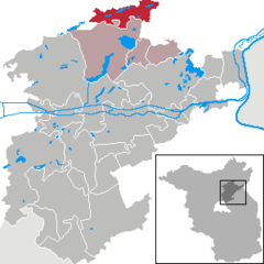
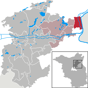
Werneuchen is a town in Brandenburg, Germany, in the district of Barnim northeast of Berlin within the metropolitan area. Most of the population of Werneuchen commutes to Berlin.
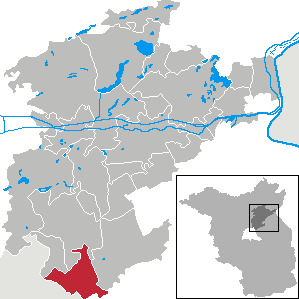
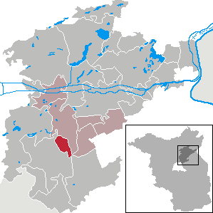
<span class="mw-page-title-main">Oderberg</span> Town in Brandenburg, Germany

Oderberg is a town in the district of Barnim, in Brandenburg in northeastern Germany. It is situated 16 km east of Eberswalde, and 27 km southwest of Schwedt, close to the border with Poland, and in close vicinity of Berlin.

<span class="mw-page-title-main">Ahrensfelde</span> Municipality in Brandenburg, Germany

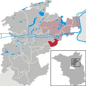
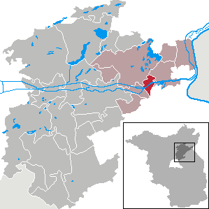
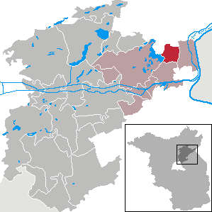
Ahrensfelde is a municipality in the district of Barnim, in Brandenburg, Germany. It is situated on the Barnim Plateau at the city limits of Berlin, about 13 km (8.1 mi) northeast of the city centre. The municipal area comprises the villages of Ahrensfelde, Blumberg, Eiche, Lindenberg, and Mehrow.

<span class="mw-page-title-main">Biesenthal</span> Town in Brandenburg, Germany

Biesenthal is a town in the district of Barnim in Brandenburg, Germany. It is the administrative seat of the Amt Amt Biesenthal-Barnim.

<span class="mw-page-title-main">Joachimsthal, Brandenburg</span> Town in Brandenburg, Germany

Joachimsthal  is a small town in the district of Barnim, in Brandenburg, Germany. It is situated within the Schorfheide-Chorin Biosphere Reserve on the isthmus between the lakes Grimnitzsee in the north and Werbellinsee in the south, about 17 km (11 mi) northwest of the district's capital Eberswalde and 55 km (34 mi) northeast of the Berlin city centre. The municipality is the administrative seat of the Amt Amt Joachimsthal.

<span class="mw-page-title-main">Schorfheide, Brandenburg</span> Municipality in Brandenburg, Germany

Schorfheide is a municipality in the Barnim district of Brandenburg, Germany. It was established in 2003 by the merger of Finowfurt and Groß Schönebeck.

<span class="mw-page-title-main">Althüttendorf</span> Municipality in Brandenburg, Germany

Althüttendorf is a municipality in the district of Barnim in Brandenburg in Germany.

<span class="mw-page-title-main">Breydin</span> Municipality in Brandenburg, Germany

Breydin is a municipality in the Barnim district of Brandenburg in Germany.

<span class="mw-page-title-main">Britz, Brandenburg</span> Municipality in Brandenburg, Germany

Britz is a municipality in the district of Barnim in Brandenburg in Germany.

<span class="mw-page-title-main">Chorin</span> Municipality in Brandenburg, Germany

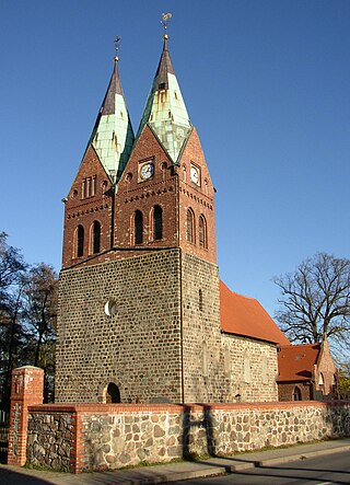
Chorin is a municipality in the district of Barnim in Brandenburg, Germany. It is most famous for its cloister and for being situated within the Schorfheide-Chorin Biosphere Reserve. It is famous for its medieval Brick Gothic Chorin Abbey and the Choriner Musiksommer music festival held there.

<span class="mw-page-title-main">Hohenfinow</span> Municipality in Brandenburg, Germany

Hohenfinow is a municipality in the Barnim district in Brandenburg, Germany. It is part of the Amt Amt Britz-Chorin-Oderberg.

<span class="mw-page-title-main">Liepe</span> Municipality in Brandenburg, Germany

Liepe is a municipality in the district of Barnim in Brandenburg in Germany.

<span class="mw-page-title-main">Lunow-Stolzenhagen</span> Municipality in Brandenburg, Germany

Lunow-Stolzenhagen is a municipality in the district of Barnim in Brandenburg in Germany.

<span class="mw-page-title-main">Marienwerder, Brandenburg</span> Municipality in Brandenburg, Germany

Marienwerder is a municipality in the district of Barnim in the state of Brandenburg, Germany.

<span class="mw-page-title-main">Melchow</span> Municipality in Brandenburg, Germany

Melchow is a municipality in the district of Barnim in Brandenburg in Germany.

<span class="mw-page-title-main">Niederfinow</span> Municipality in Brandenburg, Germany

Niederfinow is a municipality in the district of Barnim in Brandenburg in Germany.

<span class="mw-page-title-main">Parsteinsee</span> Municipality in Brandenburg, Germany

Parsteinsee is a municipality in the district of Barnim in Brandenburg in Germany.

<span class="mw-page-title-main">Rüdnitz</span> Municipality in Brandenburg, Germany

Rüdnitz is a municipality in the district of Barnim in the state of Brandenburg, Germany.

<span class="mw-page-title-main">Sydower Fließ</span> Municipality in Brandenburg, Germany

Sydower Fließ is a municipality in the district of Barnim in Brandenburg in Germany.

<span class="mw-page-title-main">Ziethen, Brandenburg</span> Municipality in Brandenburg, Germany

Ziethen is a municipality in the district of Barnim in Brandenburg in Germany.

References

  1. Landkreis Barnim Wahl der Bürgermeisterin / des Bürgermeisters, accessed 30 June 2021.
  2. "Bevölkerungsentwicklung und Flächen der kreisfreien Städte, Landkreise und Gemeinden im Land Brandenburg 2021" (PDF). Amt für Statistik Berlin-Brandenburg (in German). June 2022.
  3. Detailed data sources are to be found in the Wikimedia Commons.Population Projection Brandenburg at Wikimedia Commons