Hohenfinow

Last updated
Hohenfinow
Location of Hohenfinow within Barnim district
Hohenfinow in BAR.pngBritzJoachimsthalMarienwerderSchorfheideZiethen
Germany adm location map.svg
Red pog.svg
Hohenfinow
Brandenburg location map.svg
Red pog.svg
Hohenfinow
Coordinates: 52°49′N13°56′E / 52.817°N 13.933°E / 52.817; 13.933
Country Germany
State Brandenburg
District Barnim
Municipal assoc. Amt Britz-Chorin-Oderberg
Government
   Mayor (201924) Ronny Püschel [1]
Area
  Total21.91 km2 (8.46 sq mi)
Elevation
55 m (180 ft)
Population
 (2021-12-31) [2]
  Total520
  Density24/km2 (61/sq mi)
Time zone UTC+01:00 (CET)
  Summer (DST) UTC+02:00 (CEST)
Postal codes
16248
Dialling codes 033362
Vehicle registration BAR
Website britz-chorin-oderberg.de

Hohenfinow is a municipality in the Barnim district in Brandenburg, Germany. It is part of the Amt ("collective municipality") Amt Britz-Chorin-Oderberg.

Contents

Geography

Hohenfinow is located about 8 km (5.0 mi) east of Eberswalde. It is part of a rural area on the northeastern rim of the Barnim Plateau, south of the Finow River and the Finow Canal. The glacial valley in the north with the neighbouring municipality of Niederfinow separates it from the adjacent Uckermark region. The historic village centre is surrounded by extended fields, meadows and pine forests.

History

Parish church Kirche-hohenfinow-rr.jpg
Parish church

A fortress overlooking the Finow valley and a ford across the river was erected about 1220, after the area settled by Polabian Slavs had been conquered by the Ascanian margraves of Brandenburg. The foundations of the parish church date back to around 1250. The settlement itself was first mentioned in a 1334 deed issued by the Wittelsbach margrave Louis I.

Temporarily held by Count Henry Matthias of Thurn, the estates were sold to the Pfuel noble family in 1614. During the indecisive stance of Brandenburg in the Thirty Years' War, Hohenfinow was devastated by a contingent under Ernst von Mansfeld in 1626, and again by Imperial, Saxon and Swedish troops in the following years. The rebuilding began with three remaining farmsteads. In 1780 the cornfields of Hohenfinow were mentioned in a travel account by Johann III Bernoulli.

From 1815 to 1947, Hohenfinow was part of the Prussian Province of Brandenburg. In 1855 the Hohenfinow manor was purchased by Felix von Bethmann Hollweg (1824–1900), scion of a Frankfurt banking dynasty and father of the later German chancellor Theobald von Bethmann Hollweg, who was born here in 1856. In the last days of World War II, a unit of the "Army Detachment Steiner" rested near Hohenfinow before the troops withdraw to Eberswalde.

From 1947 to 1952, Hohenfinow was part of the State of Brandenburg, from 1952 to 1990 of the East German Bezirk Frankfurt and since 1990 again of Brandenburg.

Demography

Development of population since 1875 within the current boundaries (Blue line: Population; Dotted line: Comparison to population development of Brandenburg state; Grey background: Time of Nazi rule; Red background: Time of communist rule) Bevolkerungsentwicklung Hohenfinow.pdf
Development of population since 1875 within the current boundaries (Blue line: Population; Dotted line: Comparison to population development of Brandenburg state; Grey background: Time of Nazi rule; Red background: Time of communist rule)
Hohenfinow: Population development
within the current boundaries (2020) [3]
YearPop.±% p.a.
1875 776    
1890 758−0.16%
1910 812+0.34%
1925 879+0.53%
1933 864−0.21%
1939 872+0.15%
1946 894+0.36%
1950 1,015+3.22%
1964 829−1.44%
1971 849+0.34%
1981 639−2.80%
1985 579−2.43%
1989 580+0.04%
1990 574−1.03%
1991 563−1.92%
YearPop.±% p.a.
1992 546−3.02%
1993 539−1.28%
1994 541+0.37%
1995 539−0.37%
1996 558+3.53%
1997 569+1.97%
1998 581+2.11%
1999 571−1.72%
2000 575+0.70%
2001 555−3.48%
2002 550−0.90%
2003 543−1.27%
2004 538−0.92%
2005 537−0.19%
2006 524−2.42%
YearPop.±% p.a.
2007 513−2.10%
2008 509−0.78%
2009 521+2.36%
2010 524+0.58%
2011 519−0.95%
2012 500−3.66%
2013 512+2.40%
2014 512+0.00%
2015 526+2.73%
2016 528+0.38%
2017 525−0.57%
2018 515−1.90%
2019 522+1.36%
2020 537+2.87%

Related Research Articles

<span class="mw-page-title-main">Eberswalde</span> Town in Brandenburg, Germany

Eberswalde is a major town and the administrative seat of the district Barnim in the German State of Brandenburg, about 50 km northeast of Berlin. Population 42,144, geographical location 52°50′N13°50′E. The town is often called Waldstadt, because of the large forests around it, including the Schorfheide-Chorin Biosphere Reserve. Despite this fact, Eberswalde was an important industrial center until the German Reunification.

<span class="mw-page-title-main">Fürstenwalde</span> Town in Brandenburg, Germany

Fürstenwalde/Spree is the most populous town in the Oder-Spree District of Brandenburg, Germany.

<span class="mw-page-title-main">Oderberg</span> Town in Brandenburg, Germany

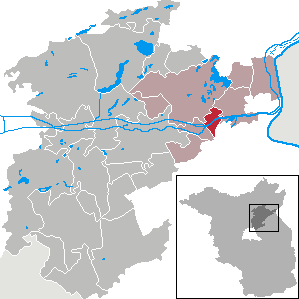
Oderberg is a town in the district of Barnim, in Brandenburg in northeastern Germany. It is situated 16 km east of Eberswalde, and 27 km southwest of Schwedt, close to the border with Poland, and in close vicinity of Berlin.

<span class="mw-page-title-main">Ahrensfelde</span> Municipality in Brandenburg, Germany

Ahrensfelde is a municipality in the district of Barnim, in Brandenburg, Germany. It is situated on the Barnim Plateau at the city limits of Berlin, about 13 km (8.1 mi) northeast of the city centre. The municipal area comprises the villages of Ahrensfelde, Blumberg, Eiche, Lindenberg, and Mehrow.

<span class="mw-page-title-main">Biesenthal</span> Town in Brandenburg, Germany

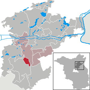
Biesenthal is a town in the district of Barnim in Brandenburg, Germany. It is the administrative seat of the Amt Amt Biesenthal-Barnim.

<span class="mw-page-title-main">Joachimsthal, Brandenburg</span> Town in Brandenburg, Germany

Joachimsthal  
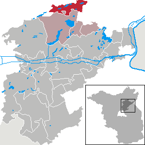
is a small town in the district of Barnim, in Brandenburg, Germany. It is situated within the Schorfheide-Chorin Biosphere Reserve on the isthmus between the lakes Grimnitzsee in the north and Werbellinsee in the south, about 17 km (11 mi) northwest of the district's capital Eberswalde and 55 km (34 mi) northeast of the Berlin city centre. The municipality is the administrative seat of the Amt Amt Joachimsthal.

<span class="mw-page-title-main">Müllrose</span> Town in Brandenburg, Germany

Müllrose(Lower Sorbian: Miłoraz) is a town in the Oder-Spree district, in Brandenburg, Germany. It is situated on the Oder-Spree Canal, 15 km southwest of Frankfurt (Oder). A part of the city is located in the Schlaube Valley Nature Park, named after the Schlaube, a 20 kilometres long river.

<span class="mw-page-title-main">Schorfheide, Brandenburg</span> Municipality in Brandenburg, Germany

Schorfheide is a municipality in the Barnim district of Brandenburg, Germany. It was established in 2003 by the merger of Finowfurt and Groß Schönebeck.

<span class="mw-page-title-main">Althüttendorf</span> Municipality in Brandenburg, Germany

Althüttendorf is a municipality in the district of Barnim in Brandenburg in Germany.

<span class="mw-page-title-main">Breydin</span> Municipality in Brandenburg, Germany

Breydin is a municipality in the Barnim district of Brandenburg in Germany.

<span class="mw-page-title-main">Britz, Brandenburg</span> Municipality in Brandenburg, Germany

Britz is a municipality in the district of Barnim in Brandenburg in Germany.

<span class="mw-page-title-main">Chorin</span> Municipality in Brandenburg, Germany

Chorin is a municipality in the district of Barnim in Brandenburg, Germany. It is most famous for its cloister and for being situated within the Schorfheide-Chorin Biosphere Reserve. It is famous for its medieval Brick Gothic Chorin Abbey and the Choriner Musiksommer music festival held there.

<span class="mw-page-title-main">Liepe</span> Municipality in Brandenburg, Germany

Liepe is a municipality in the district of Barnim in Brandenburg in Germany.

<span class="mw-page-title-main">Lunow-Stolzenhagen</span> Municipality in Brandenburg, Germany

Lunow-Stolzenhagen is a municipality in the district of Barnim in Brandenburg in Germany.

<span class="mw-page-title-main">Melchow</span> Municipality in Brandenburg, Germany

Melchow is a municipality in the district of Barnim in Brandenburg in Germany.

<span class="mw-page-title-main">Niederfinow</span> Municipality in Brandenburg, Germany

Niederfinow is a municipality in the district of Barnim in Brandenburg in Germany.

<span class="mw-page-title-main">Rüdnitz</span> Municipality in Brandenburg, Germany

Rüdnitz is a municipality in the district of Barnim in the state of Brandenburg, Germany.

<span class="mw-page-title-main">Sydower Fließ</span> Municipality in Brandenburg, Germany

Sydower Fließ is a municipality in the district of Barnim in Brandenburg in Germany.

<span class="mw-page-title-main">Ziethen, Brandenburg</span> Municipality in Brandenburg, Germany

Ziethen is a municipality in the district of Barnim in Brandenburg in Germany.

<span class="mw-page-title-main">Friedrichswalde</span> Municipality in Brandenburg, Germany

Friedrichswalde is a municipality in the district of Barnim in Brandenburg in Germany. It is situated in the Schorfheide nature reserve.

References

  1. Landkreis Barnim Wahl der Bürgermeisterin / des Bürgermeisters, accessed 30 June 2021.
  2. "Bevölkerungsentwicklung und Flächen der kreisfreien Städte, Landkreise und Gemeinden im Land Brandenburg 2021" (PDF). Amt für Statistik Berlin-Brandenburg (in German). June 2022.
  3. Detailed data sources are to be found in the Wikimedia Commons.Population Projection Brandenburg at Wikimedia Commons