
Grenada is an island country located between the Caribbean Sea and Atlantic Ocean, north of Trinidad and Tobago. It is located at 12°07′N61°40′W. There are no large inland bodies of water on the island, which consists entirely of the state of Grenada. The coastline is 121 km long. The island has 15 constituencies and speaks English. It is volcanic in origin and its topography is mountainous.

Saint Vincent and the Grenadines is a multi island Anglo-Caribbean country in the Lesser Antilles island arc, in the southeast Windward Islands, which lies in the West Indies at the southern end of the eastern border of the Caribbean Sea where the latter meets the Atlantic Ocean. The sovereign state is also frequently known simply as Saint Vincent.

Saint Vincent and the Grenadines is an island state in the Windward Islands of the Lesser Antilles, an island arc of the Caribbean Sea in North America. The country consists of the main island of Saint Vincent and the northern two-thirds of the Grenadines, a chain of small islands stretching south from Saint Vincent to Grenada. Its total land area is 390 km² of which 342.7 km² is the main island of Saint Vincent. The country's capital is at Kingstown on Saint Vincent.

St. George's is the capital of Grenada. The town is surrounded by a hillside of an old volcano crater and is on a horseshoe-shaped harbour.

Carriacou and Petite Martinique, also known as the Southern Grenadines, is a dependency of Grenada, lying north of Grenada island and south of Saint Vincent and the Grenadines in the Lesser Antilles. The islands of Carriacou and Petite Martinique belong to the island of Grenada. Together they all form the 3-island country of Grenada, Carriacou, and Petite Martinique.

The Lesser Antilles is a group of islands in the Caribbean Sea. Most form a long, partly volcanic island arc between the Greater Antilles to the north-west and the continent of South America. The islands form the eastern boundary of the Caribbean Sea with the Atlantic Ocean. Together, the Lesser Antilles and the Greater Antilles compose the Antilles. When combined with the Lucayan Archipelago, all three are known as the West Indies.
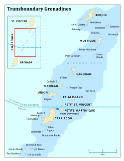
The Grenadines are a chain of small islands that lie on a line between the larger islands of Saint Vincent and Grenada in the Lesser Antilles. Nine are inhabited and open to the public : Bequia, Mustique, Canouan, Union Island, Petit St Vincent, Palm Island and Mayreau, all in Saint Vincent and the Grenadines, plus Petite Martinique and Carriacou in Grenada. Several additional privately-owned islands such as Calivigny are also inhabited. Notable uninhabited islands of the Grenadines include Petit Nevis, used by whalers, and Petit Mustique, which was the centre of a prominent real estate scam in the early 2000s.

Union Island is part of the nation of Saint Vincent and the Grenadines. It has a surface of 9 square kilometres (3.5 sq mi) and lies about 200 km west-southwest of Barbados and is within view of the islands of Carriacou and the mainland of Grenada, which lie directly south.
Carriacou is an island of the Grenadine Islands located in the southeastern Caribbean Sea, northeast of Grenada and the north coast of South America. The name is derived from the Carib language Kayryouacou.
Caille Island is a small islet between Grenada and Carriacou (Grenadines).
Diamond Island is a small islet between Grenada and Carriacou (Grenadines).
Large Island is an islet between Grenada and Carriacou (Grenadines). It is part of Carriacou and Petite Martinique, a dependency of Grenada.

Saline Island is a small islet between Grenada and Carriacou (Grenadines), owned by the John family, of Harvey Vale, Carriacou. It is located next to Frigate Island.
Grenada is a sovereign state in the West Indies in the Caribbean Sea at the southern end of the Grenadines island chain. Grenada consists of the island of Grenada itself plus six smaller islands which lie to the north of the main island. It is located northwest of Trinidad and Tobago, northeast of Venezuela and southwest of Saint Vincent and the Grenadines. Its size is 348.5 square kilometres (134.6 sq mi), and it had an estimated population of 112,200 in July 2018. Its capital is St. George's. Grenada is also known as the "Island of Spice" due to its production of nutmeg and mace crops. The national bird of Grenada is the critically endangered Grenada dove.

The following is an alphabetical list of topics related to the nation of Grenada.
This is a survey of the postage stamps and postal history of Grenada.
Calivigny Island is a small islet off the southern coast of the island of Grenada in the Caribbean. Calivigny Island covers 80 acres, with its small pond, is located between the Atlantic and Caribbean oceans by the island of Grenada off Petit Calivigny Point and can be very clearly seen just 0.140 miles from Grenada's southern coastal road in Lower Woburn or from Le Phare Bleu. It is also 0.438 miles east of Hogg Island. It is one of the most expensive resorts in the world.
Glover Island is a small islet off the southern peninsula of Grenada.