Related Research Articles
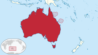
The Coral Sea Islands Territory is an external territory of Australia which comprises a group of small and mostly uninhabited tropical islands and reefs in the Coral Sea, northeast of Queensland, Australia. The only inhabited island is Willis Island. The territory covers 780,000 km2 (301,160 sq mi), most of which is ocean, extending east and south from the outer edge of the Great Barrier Reef and includes Heralds Beacon Island, Osprey Reef, the Willis Group and fifteen other reef/island groups. Cato Island is the highest point in the Territory.

Palmyra Atoll, also referred to as Palmyra Island, is one of the Northern Line Islands. It is located almost due south of the Hawaiian Islands, roughly one-third of the way between Hawaii and American Samoa. North America is about 3,300 miles northeast and New Zealand the same distance southwest, placing the atoll at the approximate center of the Pacific Ocean. The land area is 4.6 sq mi (12 km2), with about 9 miles (14 km) of sea-facing coastline and reef. There is one boat anchorage known as West Lagoon, accessible from the sea by a narrow artificial channel.

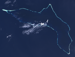
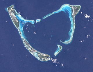
An atoll, sometimes known as a coral atoll, is a ring-shaped coral reef, including a coral rim that encircles a lagoon partially or completely. There may be coral islands or cays on the rim. Atolls are located in warm tropical or subtropical oceans and seas where corals can grow. Most of the approximately 440 atolls in the world are in the Pacific Ocean.
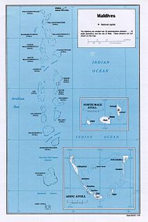
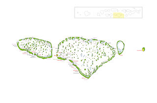
Maldives is an island country in the Indian Ocean, South Asia, south-southwest of India. It has a total land size of 298 km2 (115 sq mi) which makes it the smallest country in Asia. It consists of approximately 1,190 coral islands grouped in a double chain of 26 atolls, spread over roughly 90,000 square kilometers, making this one of the most geographically dispersed countries in the world. It has the 31st largest exclusive economic zone of 923,322 km2 (356,497 sq mi). Composed of live coral reefs and sand bars, the atolls are situated atop a submarine ridge, 960 km (600 mi) long that rises abruptly from the depths of the Indian Ocean and runs from north to south. Only near the southern end of this natural coral barricade do two open passages permit safe ship navigation from one side of the Indian Ocean to the other through the territorial waters of Maldives. For administrative purposes the Maldives government organized these atolls into twenty-one administrative divisions.
Kwajalein Atoll is part of the Republic of the Marshall Islands (RMI). The southernmost and largest island in the atoll is named Kwajalein Island, which its majority English-speaking residents often use the shortened name, Kwaj. The total land area of the atoll amounts to just over 6 square miles (16 km2). It lies in the Ralik Chain, 2,100 nautical miles southwest of Honolulu, Hawaii.

The Maldives are formed by 20 natural atolls, along with a few islands and isolated reefs today which form a pattern stretching from 7 degrees 10′ North to 0 degrees 45′ South. The largest of these atolls is Boduthiladhunmathi, while the atoll containing the most islands is Huvadhu.

Moruroa, also historically known as Aopuni, is an atoll which forms part of the Tuamotu Archipelago in French Polynesia in the southern Pacific Ocean. It is located about 1,250 kilometres (780 mi) southeast of Tahiti. Administratively Moruroa Atoll is part of the commune of Tureia, which includes the atolls of Tureia, Fangataufa, Tematangi and Vanavana. France undertook nuclear weapon tests between 1966 and 1996 at Moruroa and Fangataufa, causing international protests, notably in 1974 and 1995. The number of tests performed has been variously reported as 175 and 181.
Haa Dhaalu Atoll is the code name based on the letters of the Maldivian alphabet commonly used to refer to the administrative division officially known as South Thiladhunmathi Atoll in the Maldives.

Noonu Atoll is an administrative division of the Maldives corresponding to the southern section of Miladhunmadulu Atoll. The capital is Manadhoo. Total population of Noonu Atoll is around 10,000 people.

Baa Atoll is an administrative division of the Maldives. It consists of three separate natural atolls, namely southern Maalhosmadulu Atoll, the Fasdūtherē Atoll and the smaller natural atoll known as Goifulhafehendhu Atoll.
Kaafu Atoll is the code name given to an administrative division in the Republic of Maldives which consists of the geographical atolls of Kaashidhoo Island, Gaafaru, North Malé Atoll and South Malé Atoll. As the two Malé Atolls are the main islands of the administrative district, the entire Kaafu Atoll administrative division is officially named Malé Atoll or Malé Atolhu in the Maldivian language, Dhivehi.

Alifu Dhaalu Atoll is an administrative division of the Maldives.

Mulaku Atoll or Meemu Atoll is an administrative division of the Maldives. It corresponds to the natural atoll of the same name, also known as Mulak Atoll or 'Mulakatolhu'.

Gaafu Alifu is an administrative division of the Maldives created on February 8 1962, when Huvadhu Atoll was divided into two districts. Gaafu Alifu corresponds to the northeastern section of this large natural atoll north of the line extending between the channels of Footukandu and Vaarulu Kandu. The capital of this district is Vilingili.

Gaafu Dhaalu is an administrative district of the Maldives formed by the southwestern section of Huvadhu Atoll. It was created on February 8, 1962 when Huvadhu Atoll was divided into two districts. Gaafu Dhaalu corresponds to the Southwestern section of this large natural atoll, south of the line extending between the channels of Footukandu and Vaarulu Kandu. The capital of this region is Thinadhoo. There are 153 islands in this district, 10 of which are inhabited. This district is located about 340 kilometers south of the capital Malé.
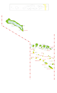
Addu Atoll, also known as Seenu Atoll, is the southernmost atoll of the Maldives. Addu Atoll, together with Fuvahmulah, located 40 km north of Addu Atoll, extend the Maldives into the Southern Hemisphere. Addu Atoll is located 540 km south of Malé, the country's capital. Administratively, Addu Atoll is the location of Addu City, one of the four cities of the Maldives. Addu City consists of the inhabited areas of Addu Atoll, namely the natural islands of Hulhudhoo, Meedhoo, Maradhoo, Feydhoo, and Hithadhoo.. In addition to the areas that are included as a part of Addu City, Addu Atoll has a number of other inhabited and uninhabited islands, including the island of Gan, where Gan International Airport is located.

Gnaviyani Atoll is one of the administrative divisions of the Maldives corresponding to the natural atoll, Fuvahmulah. Surfacewise this is the smallest administrative unit in the Maldives, situated in the Equatorial Channel between Huvadhu Atoll and Addu Atoll.
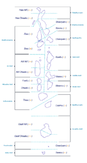
The Administrative Divisions of the Maldives refers to the various units of government that provide local government services in the Maldives. According to the Decentralization Act 2010, the administrative divisions of the Maldives would consist of atolls, islands, and cities; each administered by their own local council, under the basic terms of home rule. Geographically, the Maldives are formed by a number of natural atolls plus a few islands and isolated reefs which form a pattern from North to South. Administratively, there are currently 189 islands, 18 atolls and 4 cities in the Maldives.

Funafuti is an atoll and the capital of the island nation of Tuvalu. It has a population of 6,320 people, making it the country's most populous atoll, with 60.15 per cent of Tuvalu's population. It consists of a narrow sweep of land between 20 and 400 metres wide, encircling a large lagoon 18 km long and 14 km wide. The average depth of the Funafuti lagoon is about 20 fathoms. With a surface area of 275 square kilometres (106.2 sq mi), it is by far the largest lagoon in Tuvalu. The land area of the 33 islets around the atoll of Funafuti totals 2.4 square kilometres (0.9 sq mi); taken together, they constitute less than one per cent of the total area of the atoll. Cargo ships can enter Funafuti's lagoon and dock at the port facilities on Fongafale.

The Maldives, officially the Republic of Maldives, is a small archipelagic state in South Asia. It lies in the Indian Ocean southwest of Sri Lanka and India, about 700 kilometres from the Asian continent's mainland. The chain of 26 atolls stretches across the Equator from Ihavandhippolhu Atoll in the north to Addu Atoll in the south. The land area is roughly 298 square kilometres. Malé is the capital.
References
- Divehiraajjege Jōgrafīge Vanavaru. Muhammadu Ibrahim Lutfee. G.Sōsanī.[ clarification needed ]
| | This Maldives location article is a stub. You can help Wikipedia by expanding it. |