
Roswell is a city in northern Fulton County, Georgia, United States. At the official 2010 census, the city had a population of 88,346. The 2020 estimated population was 94,884, making Roswell the state's ninth largest city. A close suburb of Atlanta, Roswell has an affluent historic district.

The New York City Landmarks Preservation Commission (LPC) is the New York City agency charged with administering the city's Landmarks Preservation Law. The LPC is responsible for protecting New York City's architecturally, historically, and culturally significant buildings and sites by granting them landmark or historic district status, and regulating them after designation. It is the largest municipal preservation agency in the nation. As of July 1, 2020, the LPC has designated more than 37,000 landmark properties in all five boroughs. Most of these are concentrated in historic districts, although there are over a thousand individual landmarks, as well as numerous interior and scenic landmarks.

The South Street Seaport is a historic area in the New York City borough of Manhattan, centered where Fulton Street meets the East River, and adjacent to the Financial District, in Lower Manhattan. The Seaport is a designated historic district, and is distinct from the neighboring Financial District. It is part of Manhattan Community Board 1 in Lower Manhattan, and is bounded by the Financial District to the west, southwest, and north; the East River to the southeast; and the Two Bridges neighborhood to the northeast.
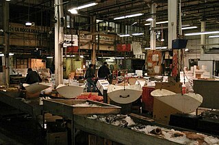
The Fulton Fish Market is a fish market in Hunts Point, a section of the New York City borough of the Bronx, in New York, United States. It was originally a wing of the Fulton Market, established in 1822 to sell a variety of foodstuffs and produce. In November 2005, the Fish Market relocated to a new facility in Hunts Point in the Bronx, from its historic location near the Brooklyn Bridge along the East River waterfront at and above Fulton Street in the Financial District, Lower Manhattan.
The Hunts Point Cooperative Market is a 24/7 wholesale food market located on 60 acres (24 ha) in the Hunts Point neighborhood of the Bronx, New York City. The largest food distribution center of its kind in the world, it earns annual revenues of over $2 billion.

Fulton Street is a busy street located in Lower Manhattan in New York City. Located in the Financial District, a few blocks north of Wall Street, it runs from West Street at the site of the World Trade Center to South Street, terminating in front of the South Street Seaport. The westernmost two blocks and the easternmost block are pedestrian streets.

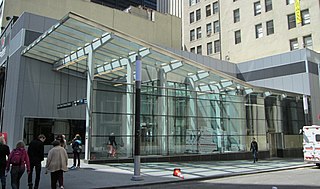
Fulton Center is a subway and retail complex centered at the intersection of Fulton Street and Broadway in Lower Manhattan, New York City. The complex was built as part of a $1.4 billion project by the Metropolitan Transportation Authority (MTA), a public agency of the state of New York, to rehabilitate the New York City Subway's Fulton Street station. The work involved constructing new underground passageways and access points into the complex, renovating the constituent stations, and erecting a large station building that doubles as a part of the Westfield World Trade Center mall.

The Maine Avenue Fish Market also known as the Fish Wharf, or simply, the Wharf, is an open-air seafood market in Southwest Washington, D.C., a local landmark and one of the few that remain on the east coast of the United States. It is the oldest continuously operating fish market in the United States, founded 17 years earlier than New York City's Fulton Fish Market.

Nassau Street is in the Financial District, within the borough of Manhattan in New York City. Its southern end is at the intersection with Broad Street and Wall Street, and its northern end is at Spruce Street, at Pace University near the foot of the Brooklyn Bridge. For its entire route, Nassau Street runs one block east of Broadway and Park Row.
The Dey Street Passageway or Dey Street Concourse is a 350-foot-long (110 m) underground passageway in Manhattan, New York City, built as part of the Fulton Center project to rehabilitate the Fulton Street station complex and improve connectivity in Lower Manhattan. The Dey Street Passageway lies under Dey Street in Lower Manhattan, between Broadway in the eastern end, and Church Street in its western end.
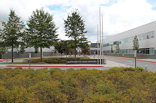
Alpharetta High School is a public high school located in Alpharetta, Georgia, United States within the Fulton County School System. Atlanta Magazine named Alpharetta High School one of the metro Atlanta area's best all-around high schools. In 2020, the U.S. News & World Report ranked the school #7 in Georgia and #281 nationally.

Dey Street is a short street in Lower Manhattan, in New York City. It passes the west side of the World Trade Center site and the World Trade Center Transportation Hub. It runs for one block between Church Street and Broadway. It originally ran to West Street, but the western reaches were demolished to make way for the World Trade Center in the late 1960s. It now extends to Greenwich Street. 15 Dey Street is the site of the first transcontinental telephone call.

Maiden Lane is an east–west street in the Financial District of the New York City borough of Manhattan. Its eastern end is at South Street, near the South Street Seaport, and its western end is at Broadway near the World Trade Center site, where it becomes Cortlandt Street.
Church Street and Trinity Place form a single north–south roadway in Lower Manhattan, New York City. Its northern end is at Canal Street and its southern end is at Morris Street, where Trinity Place merges with Greenwich Street. The dividing point is Liberty Street.

Canal Crossing is a New Urbanism project on the eastern side of Jersey City, New Jersey between Jackson Hill in Greenville/Bergen-Lafayette and Liberty State Park. The approximately 111 acre area, previously designated for industrial and distribution uses has been re-zoned for transit-oriented residential and commercial use and the construction of a neighborhood characterized as a sustainable community. The name is inspired by the Morris Canal, which once traversed the district in a general north and south alignment. The brownfield site must first undergo remediation of toxic waste, much of it left by PPG Industries The redevelopment plans call for 7,000 housing units, mainly "mid-rise" buildings, and a greenway along the former canal, directly south of the 17-acre Berry Lane Park.

The World Chess Championship 2016 was a chess match between the reigning world champion Magnus Carlsen and the challenger Sergey Karjakin to determine the World Chess Champion. Carlsen had been world champion since 2013, while Karjakin qualified as challenger by winning the 2016 Candidates Tournament. The best-of-12 match, organized by FIDE and its commercial partner Agon, was played in New York City between 10 and 30 November 2016.
The Malaysian Chess Championship is organized by the Malaysian Chess Federation. Known as the National Closed Chess Championship prior to 2016, the first edition was held in 1974. A separate Malaysian Women's Chess Championship has also been held annually since 1990. FIDE Master Christi Hon has won the national title a record five times, while Woman International Master Siti Zulaikha Foudzi has won the women's title a record eight times. Curiously, it has occurred twice that a pair of siblings have won the national and the women's titles in the same year: Kamal Ariffin Wahiddudin and Nurul Huda Wahiduddin in 1991, and Zarul Shazwan Zullkafli and Nur Shazwani Zullkafli in 2007.

Cortlandt Street is a west-east street in the Financial District of Lower Manhattan, New York City. It runs one block from Broadway to Church Street, then continues an additional block as the non-vehicular Cortlandt Way from Church to Greenwich Street. At its eastern end, the street continues as Maiden Lane.

