Related Research Articles
The Coral Sea Islands Territory is an external territory of Australia which comprises a group of small and mostly uninhabited tropical islands and reefs in the Coral Sea, north-east of Queensland, Australia. The only inhabited island is Willis Island. The territory covers 780,000 km2 (301,160 sq mi), most of which is ocean, extending east and south from the outer edge of the Great Barrier Reef and includes Heralds Beacon Island, Osprey Reef, the Willis Group and fifteen other reef/island groups. Cato Island is the highest point in the Territory.

The grey reef shark is a species of requiem shark, in the family Carcharhinidae. One of the most common reef sharks in the Indo-Pacific, it is found as far east as Easter Island and as far west as South Africa. This species is most often seen in shallow water near the drop-offs of coral reefs. It has the typical "reef shark" shape, with a broad, round snout and large eyes. It can be distinguished from similar species by the plain or white-tipped first dorsal fin, the dark tips on the other fins, the broad, black rear margin on the tail fin, and the lack of a ridge between the dorsal fins. Most individuals are less than 1.88 m (6.2 ft) long.

Bora Bora is an island group in the Leeward Islands. The Leeward Islands comprise the western part of the Society Islands of French Polynesia, which is an overseas collectivity of the French Republic in the Pacific Ocean. Bora Bora has a total land area of 30.55 km2 (12 sq mi). The main island, located about 230 kilometres northwest of Papeete, is surrounded by a lagoon and a barrier reef. In the center of the island are the remnants of an extinct volcano, rising to two peaks, Mount Pahia and Mount Otemanu; the highest point is at 727 m (2,385 ft). Bora Bora is part of the Commune of Bora-Bora, which also includes the atoll of Tūpai. The languages spoken in Bora Bora are Tahitian and French. However, due to the high tourism population, many natives of Bora Bora have learned to speak English.

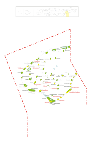
The Maldives are formed by 20 natural atolls, along with a few islands and isolated reefs today which form a pattern stretching from 7 degrees 10′ North to 0 degrees 45′ South. The largest of these atolls is Boduthiladhunmathi, while the atoll containing the most islands is Huvadhu.

Rangiroa or Te Kokōta is the largest atoll in the Tuamotus and one of the largest in the world.

The Great Blue Hole is a giant marine sinkhole off the coast of Belize. It lies near the center of Lighthouse Reef, a small atoll 70 km (43 mi) from the mainland and Belize City. The hole is circular in shape, 318 m (1,043 ft) across and 124 m (407 ft) deep. It has a surface area of 70,650 square metres (760,500 sq ft). It was formed during several episodes of quaternary glaciation when sea levels were much lower. Analysis of stalactites found in the Great Blue Hole shows that formation took place 153,000, 66,000, 60,000, and 15,000 years ago. As the ocean began to rise again, the cave was flooded. The Great Blue Hole is a part of the larger Belize Barrier Reef Reserve System, a UNESCO World Heritage Site.
Noonu Atoll is an administrative division of the Maldives corresponding to the southern section of Miladhunmadulu Atoll. The capital is Manadhoo. Total population of Noonu Atoll is around 10,000 people.

Baa Atoll is an administrative division of the Maldives. It consists of three separate natural atolls, namely southern Maalhosmadulu Atoll, the Fasdūtherē Atoll and the smaller natural atoll known as Goifulhafehendhu Atoll.
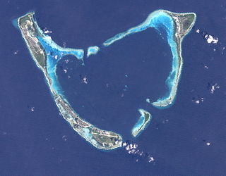
Addu Atoll, also known as Seenu Atoll, is the southernmost atoll of the Maldives. Addu Atoll, together with Fuvahmulah, located 40 km north of Addu Atoll, extend the Maldives into the Southern Hemisphere. Addu Atoll is located 540 km south of Malé, the country's capital. Administratively, Addu Atoll is the location of Addu City, one of the four cities of the Maldives. Addu City consists of the inhabited areas of Addu Atoll, namely the natural islands of Hulhudhoo, Meedhoo, Maradhoo, Feydhoo, and Hithadhoo.. In addition to the areas that are included as a part of Addu City, Addu Atoll has a number of other inhabited and uninhabited islands, including the island of Gan, where Gan International Airport is located.

Gaafaru is one of the inhabited islands of Kaafu Atoll, the only island of the natural atoll known as Gaafaru.

The Tubbataha Natural Park, also known as the Tubbataha Reefs Natural Park, is a protected area of the Philippines located in the middle of the Sulu Sea. The marine and bird sanctuary consists of two huge atolls and the smaller Jessie Beazley Reef covering a total area of 97,030 hectares. It is located 150 kilometres (93 mi) southeast of Puerto Princesa, the capital of Palawan. The uninhabited islands and reefs are part of the island municipality of Cagayancillo, located roughly 130 kilometers (81 mi) to the northeast of the reef.

Shark tourism is a form of eco-tourism that allows people to dive with sharks in their natural environment. This benefits local shark populations by educating tourists and through funds raised by the shark tourism industry. Communities that previously relied on shark finning to make their livelihoods are able to make a larger profit from diving tours while protecting the local environment. People can get close to the sharks by free- or scuba diving or by entering the water in a protective cage for more aggressive species. Many of these dives are done by private companies and are often baited to ensure shark sightings, a practice which is highly controversial and under review in many areas.

Haddhunmathi or LaamuAtoll is an administrative division of the Maldives. The administrative capital is Fonadhoo Island. It corresponds to the natural atoll of the same name. It is mostly rimmed by barrier reefs, the broadest of which are topped by islands. There are many islands along its eastern and southern boundaries. This atoll is quite regular excepting for the projection of the reef at its NE corner. It closely resembles Kolhumadulhu, its neighbour further north. Owing to its typical atoll shape, it differs in no respect from atolls in the Pacific Ocean, save for its greater size. Its reefs are generally of little breadth, with no signs of vilu, except for its eastern fringes which are covered with islands that are quite large by Maldivian standards. The lagoon is comparatively open, containing scattered shoal patches; the bottom is muddy and the average depth is from 30 to 34 fathoms.
Kardiva Channel is a broad channel running from southwest to northeast and cutting across the Maldive atoll chain. This channel divides the Northern from the Central atolls of the Maldives.

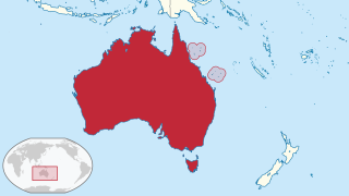
The Maldives, officially the Republic of Maldives, is a small archipelagic state in South Asia. It lies in the Indian Ocean southwest of Sri Lanka and India, about 700 kilometres (430 mi) from the Asian continent's mainland. The chain of 26 atolls stretches across the Equator from Ihavandhippolhu Atoll in the north to Addu Atoll in the south. The land area is roughly 298 square kilometres. Malé is the capital.
There are broad channels between the Atolls of the Maldives known locally as 'kandu'. The deepness and broadness of the channels vary from channel to channel.

Haa Alif Atoll is the code name based on the letters of the Maldivian alphabet commonly used to refer to the administrative division officially known as North Thiladhunmathi Atoll in the Maldives.

Landaa Giraavaru, often called Four Seasons at Landaagiraavaru, is an island in the Baa Atoll in the Maldives. Home to a luxury Four Seasons resort since 2004 with rates from USD $1,400 per night, it is one of the many island resorts of the Maldives.
The following index is provided as an overview of and topical guide to Wikipedia's articles on recreational dive sites. The level of coverage may vary:

Recreational dive sites are specific places that recreational scuba divers go to enjoy the underwater environment or for training purposes. They include technical diving sites beyond the range generally accepted for recreational diving. In this context all diving done for recreational purposes is included. Professional diving tends to be done where the job is, and with the exception of diver training and leading groups of recreational divers, does not generally occur at specific sites chosen for their easy access, pleasant conditions or interesting features.
References
- Divehiraajjege Jōgrafīge Vanavaru. Muhammadu Ibrahim Lutfee. G.Sōsanī.
| | This Maldives location article is a stub. You can help Wikipedia by expanding it. |