Lillehammer is a municipality in Innlandet county, Norway. It is located in the traditional district of Gudbrandsdal. The administrative centre of the municipality is the town of Lillehammer. Some of the more notable villages in the municipality include Fåberg, Hunderfossen, Jørstadmoen, Vingnes, and Vingrom.

Oppland is a former county in Norway which existed from 1781 until its dissolution on 1 January 2020. The old Oppland county bordered the counties of Trøndelag, Møre og Romsdal, Sogn og Fjordane, Buskerud, Akershus, Oslo and Hedmark. The county administration was located in the town of Lillehammer.
Jevnaker is a municipality in Akershus county, Norway. The administrative centre of the municipality is the village of Jevnaker with a population of 4,302.

Follebu is a village in Gausdal Municipality in Innlandet county, Norway. The village is located along the river Gausa, about 3 kilometres (1.9 mi) to the southeast of the village of Segalstad bru. The town of Lillehammer lies about 15 kilometres (9.3 mi) to the southeast of Follebu.
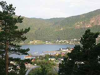
Kyrksæterøra is the administrative center of the municipality of Heim in Trøndelag county, Norway. The village was known as the "white town of Hemnfjorden" at one time because there were only white houses. It is located at the end of Hemnfjorden, about 5 kilometres (3.1 mi) southwest of the village of Holla. The villages of Hellandsjøen and Heim both lie to the north and the village of Vinjeøra lies to the south. Hemne Church is located in the village. Norwegian County Road 680 passes through the village. The newspaper Søvesten has been published in Kyrksæterøra since 1994.

is a town in Sel Municipality in Innlandet county, Norway. The town is also the administrative centre of the municipality. The town is located at the confluence of the Gudbrandsdalslågen and Otta rivers. The European route E6 highway runs through the town. The Dovrebanen railway line also passes through the town, stopping at the Otta Station. The 2.13-square-kilometre (530-acre) town has a population (2021) of 2,283 and a population density of 1,073 inhabitants per square kilometre (2,780/sq mi).

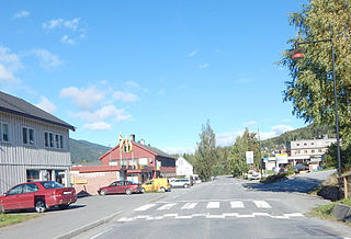
Fåvang is a village in Ringebu Municipality in Innlandet county, Norway. The village is located in the Gudbrandsdal valley, along the Gudbrandsdalslågen river, about 50 kilometres (31 mi) north of the town of Lillehammer. The European route E6 highway runs through the village, right along the river. The 0.96-square-kilometre (240-acre) village has a population (2021) of 720 and a population density of 750 inhabitants per square kilometre (1,900/sq mi).
Skoger is a village in Drammen Municipality in Buskerud county, Norway. The village is located just north of the Vestfold county border, about 6 kilometres (3.7 mi) south of the centre of the town of Drammen. The villages of Klever and Eikeberg are located about 4 kilometres (2.5 mi) to the south and the village of Sande i Vestfold is located about 11 kilometres (6.8 mi) to the south.

Vingrom is a village in Lillehammer Municipality in Innlandet county, Norway. The village is located along the lake Mjøsa, just north of the border with Gjøvik Municipality, and about 10 kilometres (6.2 mi) south of the town of Lillehammer. The European route E6 highway runs through the village. Vingrom Church lies about 3 kilometres (1.9 mi) north of the village.

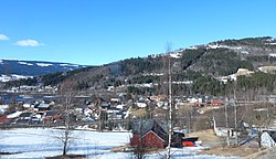
Granrudmoen is the largest village in Øyer Municipality in Innlandet county, Norway. The village is located in the Gudbrandsdal valley, along the Gudbrandsdalslågen river in the southern part of the municipality. It is the commercial centre of the municipality. It is located along the European route E6 highway, about 15 kilometres (9.3 mi) north of the town of Lillehammer. The municipal centre of Tingberg is located about 5 kilometres (3.1 mi) to the north.

Fåberg is a former municipality in the old Oppland county, Norway. The 478-square-kilometre (185 sq mi) municipality existed from 1838 until 1964. Now, it is part of Lillehammer Municipality in Innlandet county. The administrative centre was the village of Fåberg.

Biri is a village in Gjøvik Municipality in Innlandet county, Norway. The village is located along the western shore of the lake Mjøsa, about 20 kilometres (12 mi) north of the town of Gjøvik. The Norwegian National Road 4 highway runs through the village which is near the Mjøsa Bridge about halfway between the towns of Lillehammer and Gjøvik. The 2.03-square-kilometre (500-acre) village has a population (2021) of 1,495 and a population density of 738 inhabitants per square kilometre (1,910/sq mi).

Kolbu is a village in Østre Toten Municipality in Innlandet county, Norway. The village is located in the traditional region of Toten, about 6 kilometres (3.7 mi) to the southwest of the village of Lena, the administrative centre of the municipality. The village lies in the western part of the municipality in an agricultural area, not far from the municipal border with Vestre Toten. Kolbu Church is a cruciform church from 1730 that is located just outside the village centre.

Hægeland or Hægelandskrossen is a village in Vennesla municipality in Agder county, Norway. The village is located along the northeastern shore of the lake Hægelandsvatnet, a short distance south of the Kilefjorden. The Norwegian National Road 9 runs north-south through the village, just past Hægeland Church. The village of Bjelland lies about 15 kilometres (9.3 mi) to the east and the villages of Skarpengland and Øvrebø both lie about 15 kilometres (9.3 mi) to the south. The village of Øvre Eikeland lies about 2 kilometres (1.2 mi) southeast of Hægeland, along the Rv9 highway.

Borre is a village in Horten Municipality in Vestfold county, Norway. The village is located about 5 kilometres (3.1 mi) south of the town of Horten, along the shores of the Ytre Oslofjord. It sits about 4 kilometres (2.5 mi) north of the town of Åsgårdstrand and about 3 kilometres (1.9 mi) east of the village of Skoppum.
Tretten is a village in Øyer Municipality in Innlandet county, Norway. The village is located on the Losna lake, which is part of the Gudbrandsdalslågen river. Tretten is located in the Gudbrandsdal valley, along the Gudbrandsdalslågen river in the southern part of the municipality. It is located along the European route E6 highway, about 25 kilometres (16 mi) north of the town of Lillehammer. The municipal center of Tingberg lies about 5 kilometres (3.1 mi) to the southeast of Tretten.

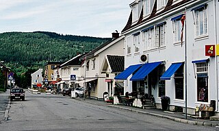
Tingberg or Øyer is the administrative centre of Øyer Municipality in Innlandet county, Norway. The village is located in the Gudbrandsdal valley, along the Gudbrandsdalslågen river in the southern part of the municipality. It is located along the European route E6 highway, about 20 kilometres (12 mi) north of the town of Lillehammer. The village of Tretten lies about 5 kilometres (3.1 mi) to the northwest and the village of Granrudmoen lies about 5 kilometres (3.1 mi) to the south.
Gjøvik is a town in Gjøvik Municipality in Innlandet county, Norway. The town is the administrative centre of Gjøvik Municipality. It is located on the western shore of the large lake Mjøsa, about 45 kilometres (28 mi) south of the town of Lillehammer and about 20 kilometres (12 mi) west from the town of Hamar.

Fåberg Church is a parish church of the Church of Norway in Lillehammer Municipality in Innlandet county, Norway. It is located in the village of Fåberg. It is the church for the Fåberg parish which is part of the Sør-Gudbrandsdal prosti (deanery) in the Diocese of Hamar. The red, wooden church was built in a cruciform design in 1727 using plans drawn up by the architect Svend Tråseth. The church seats about 292 people.
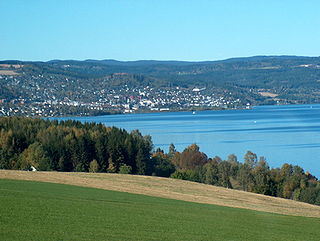
Lillehammer is a town which is the administrative centre of Lillehammer Municipality in Innlandet county, Norway. The town is located along the river Gudbrandsdalslågen at the northern end of the lake Mjøsa in the southern Gudbrandsdal valley. Prior to the county merger on 1 January 2020, Lillehammer was the administrative centre of Oppland county.