
The wild goat is a widespread species of goat, with a distribution ranging from Europe and Asia Minor to Central Asia and the Middle East. It has been listed as vulnerable on the IUCN Red List since 1996. It is considered the ancestor of the domestic goat.

The Jamrud Fort is located beside Bab-e-Khyber at the entrance to the Khyber Pass from the Peshawar side in the Tribal districts of KPK, Pakistan.
125th Anniversary Çayyolu Stage, is a theatre in Çayyolu suburb of Çankaya district in Ankara, Turkey. It is operated by the Turkish State Theatres.
Bukowiec is a village in the administrative district of Gmina Czarnków, within Czarnków-Trzcianka County, Greater Poland Voivodeship, in west-central Poland.
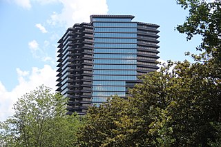
Three Ravinia Drive is a skyscraper located in the city of Dunwoody, in metropolitan Atlanta. Standing 31 stories and 444 feet tall, it is the tallest building in Dunwoody. Ravinia was developed by Gerald Hines Interests of Houston, Texas, in 1991. It is part of a large business complex that includes the twin 17-story towers of One and Two Ravinia Drive, a 15-story Crowne Plaza Hotel and a park.
Wood-Dene School was a private school for the creative arts in the English county of Norfolk in Great Britain, closing during March 2010. The school was located in a former rectory, to which additional facilities have been added.
Zaselje is a village in the municipality of Požega, western Serbia. According to the 2002 census, the village has a population of 482 people.
Elasmaria is a clade of iguanodont ornithopods known from Cretaceous deposits in South America, Antarctica, and Australia.
Kızılca, Çubuk is a village in the District of Çubuk, Ankara Province, Turkey.
Newburg Township is a township in Mitchell County, Iowa, USA.
The Espace Métal is a museum located in the ancient Charcoal Hall at Grossouvre, near to St Amand Monrond in the Cher department in the Centre-Val de Loire region of France. The museum is an Anchor point on the European Route of Industrial Heritage.
Kisad Road is a major road in Baguio in the Philippines. It connects from Aspiras-Palispis Highway to Shuntug Road in the city's downtown core. Burnham Park, which is named after Daniel Burnham, is located along the road.
The Governor Pack Road is a major highway in Baguio, Philippines, named for the American William F. Pack, who was appointed Military Governor of Benguet on November 15, 1901 and served as the civilian Governor of Mountain Province from 1909 to 1915.
Legarda Road is a major road in Baguio in the Philippines that connects from Aspiras-Palispis Highway to Yandoc Street and Urbano Street.
The Loakan Road is a 6.2-kilometer (3.9 mi), national secondary road in Baguio, Philippines. It provides access to Loakan Airport located in the outskirts of the city. It is designated as a component of National Route 231 (N231) of the Philippine highway network.
Amparo Heights Road is a major road in Baguio in the Philippines that connects from Kennon Road to Bakakeng Sur Road.
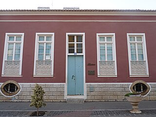
Museu Etnográfico da Praia is an ethnographic museum in the Cape Verdean capital of Praia on the island of Santiago. It is located at 45 Rua 5 de Julho, in the historic part of the city, the Plateau. The museum was opened in November 1997 and is located in a 19th century building. The museum contains a selection of objects that represent the traditional uses and customs of the Cape Verdean people.
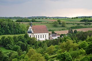
Weggental is a Roman Catholic pilgrimage church, built in the Baroque period, close to Rottenburg am Neckar.
Free Grace Baptist Church, Twickenham is a church that meets in a former Salvation Army hall at Powdermill Lane, Twickenham, TW2 6EJ in the London Borough of Richmond upon Thames. It was founded in 1965 and is a member of the Association of Grace Baptist Churches.

National Cycle Network (NCN) Route 665 is a Sustrans route from Wetherby to South West York. Two sections of the route are open. As of summer 2017 the route is not fully signed. The central section between Tadcaster and Thorp Arch Trading Estate is still a proposal.


