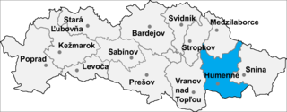
Závada is a village and municipality in Humenné District in the Prešov Region of north-east Slovakia.
Hyōgo Station is a railway station in Hyōgo-ku, Kobe, Hyōgo Prefecture, Japan, operated by the West Japan Railway Company.
Leonowo is a village in the administrative district of Gmina Osięciny, within Radziejów County, Kuyavian-Pomeranian Voivodeship, in north-central Poland.

Zborowskie is a village in the administrative district of Gmina Zduńska Wola, within Zduńska Wola County, Łódź Voivodeship, in central Poland. It lies approximately 13 kilometres (8 mi) north-west of Zduńska Wola and 46 km (29 mi) west of the regional capital Łódź.
Lasochów is a village in the administrative district of Gmina Małogoszcz, within Jędrzejów County, Świętokrzyskie Voivodeship, in south-central Poland. It lies approximately 8 kilometres (5 mi) west of Małogoszcz, 20 km (12 mi) north-west of Jędrzejów, and 33 km (21 mi) west of the regional capital Kielce.
Andruszkowice is a village in the administrative district of Gmina Samborzec, within Sandomierz County, Świętokrzyskie Voivodeship, in south-central Poland. It lies approximately 4 kilometres (2 mi) north-east of Samborzec, 4 km (2 mi) south-west of Sandomierz, and 80 km (50 mi) east of the regional capital Kielce.
Wojciechów is a village in the administrative district of Gmina Krasocin, within Włoszczowa County, Świętokrzyskie Voivodeship, in south-central Poland. It lies approximately 6 kilometres (4 mi) north-east of Krasocin, 17 km (11 mi) north-east of Włoszczowa, and 32 km (20 mi) west of the regional capital Kielce.
Jelonek is a village in the administrative district of Gmina Lipsko, within Lipsko County, Masovian Voivodeship, in east-central Poland.
Wymysły is a village in the administrative district of Gmina Krasnosielc, within Maków County, Masovian Voivodeship, in east-central Poland.
Grabina is a village in the administrative district of Gmina Łąck, within Płock County, Masovian Voivodeship, in east-central Poland. It lies approximately 4 kilometres (2 mi) north-east of Łąck, 9 km (6 mi) south of Płock, and 96 km (60 mi) west of Warsaw.
Nowe Iganie is a village in the administrative district of Gmina Siedlce, within Siedlce County, Masovian Voivodeship, in east-central Poland.
Mieleszyn is a village in Gniezno County, Greater Poland Voivodeship, in west-central Poland. It is the seat of the gmina called Gmina Mieleszyn. It lies approximately 17 kilometres (11 mi) north-west of Gniezno and 50 km (31 mi) north-east of the regional capital Poznań.
Józefowo is a village in the administrative district of Gmina Babiak, within Koło County, Greater Poland Voivodeship, in west-central Poland. It lies approximately 3 kilometres (2 mi) north of Babiak, 19 km (12 mi) north of Koło, and 120 km (75 mi) east of the regional capital Poznań.
Zalesie is a village in the administrative district of Gmina Ostrów Wielkopolski within Ostrów Wielkopolski County, Greater Poland Voivodeship in west-central Poland.
Klecie is a village in the administrative district of Gmina Stare Pole, within Malbork County, Pomeranian Voivodeship, in northern Poland. It lies approximately 4 kilometres (2 mi) south-west of Stare Pole, 10 km (6 mi) east of Malbork, and 52 km (32 mi) south-east of the regional capital Gdańsk.
Olszynka is a village in the administrative district of Gmina Korsze, within Kętrzyn County, Warmian-Masurian Voivodeship, in northern Poland.
Strzepowo, , is a village in the administrative district of Gmina Będzino, within Koszalin County, West Pomeranian Voivodeship, in north-western Poland. It lies approximately 9 kilometres (6 mi) south-west of Będzino, 21 km (13 mi) west of Koszalin, and 120 km (75 mi) north-east of the regional capital Szczecin.

Crestomere is an unincorporated community in central Alberta in Ponoka County, located on Highway 53, 45 kilometres (28 mi) north of Red Deer.
N'Gonga is a village and rural commune in Niger.
Mathiasberg is a hill of Brandenburg, Germany.


