Gaer is a community and electoral district ("ward") of the city of Newport, South Wales.

Merthyr Mawr is a village and community in Bridgend, Wales. The village is about 2½ miles from the centre of Bridgend town. The population of the community at the 2011 census was 267. The community occupies the area west of the Ewenny River, between Bridgend and Porthcawl. It takes in the settlement of Tythegston and a stretch of coastal sand dunes known as Merthyr Mawr Warren. It is in the historic county of Glamorgan.

Allt yr Esgair is a hill in the Brecon Beacons National Park in Powys, Wales. It is commonly referred to locally as simply 'The Allt'. The Welsh name signifies 'wooded slope of the ridge'. It takes the form of a northwest-southeast aligned ridge which rises to a height of 393m and which overlooks the valley of the River Usk to the west and south. To the northeast are panoramic views across Llangorse Lake to the Black Mountains There is a viewfinder on the summit erected as a monument to Eirene Lloyd White, Baroness White of Rhymney. It is a Marilyn with a prominence of 199 metres.

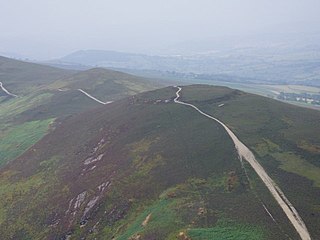
Y Garn Goch is a hill in the Brecon Beacons National Park in the east of Carmarthenshire, Wales. The name means the 'red cairn'. It lies near the village of Bethlehem, three miles southwest of Llangadog and four miles east of Llandeilo on the southern side of the broad Towy Valley. It is also commonly known as either Garn Goch or Carn Goch. Current owners and land managers are the Brecon Beacons National Park Authority.
Gaer is the name of a hill in the Black Mountains of the Brecon Beacons National Park in Monmouthshire, south Wales. It lies at the southern end of the long ridge between the valley of the Grwyne Fawr and the Vale of Ewyas one mile to the north of Bryn Arw and 3 miles northeast of Sugarloaf. Its summit at 427m above sea level sits within an Iron Age hillfort known as Twyn y Gaer.

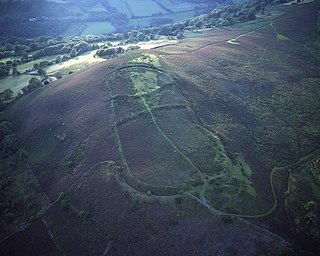
Moel y Gaer is an Iron Age hillfort at the northern end of the Clwydian Range, located on a summit overlooking the valley of the River Wheeler, near the village of Bodfari, Denbighshire, Wales, five miles north-east of Denbigh. The site is a scheduled monument, classified as a prehistoric defensive hillfort.

Moel y Gaer, also known as Moel-y-Gaer Camp or Moel y Gaer Hillfort, is an Iron Age hillfort located on a western spur of the Clwydian Range, near the village of Llanbedr, Denbighshire, Wales. The site is a scheduled monument, classified as a prehistoric defensive hillfort.
Moel y Gaer is an Iron Age hillfort on a summit of Llantysilio Mountain, northwest of the town of Llangollen, Denbighshire, Wales. The site is a scheduled monument classified as a prehistoric defensive hillfort.

Ceredigion is a large rural county in West Wales. It has a long coastline of Cardigan Bay to the west and the remote moorland of the Cambrian Mountains in the east, with the mountainous terrain of Plynlimon in the northeast. Ceredigion has a total of 264 scheduled monuments. That is too many to have on a single list page, so for convenience the list is divided into two, 163 prehistoric sites and 101 Roman, Medieval and Post Medieval sites.
Craig Ty-Isaf is a small hillfort in Baglan community, Neath Port Talbot, in South Wales. It is one of three hillforts on the area of hillside known as Mynydd y Gaer, and is within Briton Ferry Woods. The hillfort is on the SW side of the hill, overlooking Baglan, an oval enclosing some 0.2ha. A broad rubble bank forms the oval enclosure, and on the east two further banks mean that the area of banks and ditches encompasses a much larger area for the site as a whole, which is a Scheduled Monument. There are various internal features thought to be the result of more recent test cuts for mineral extraction.

Buarth-y-Gaer is an Iron Age hillfort or enclosure on the summit of Mynydd-y-Gaer, 300 m (980 ft) above sea level. It is in Briton Ferry community, near Neath, in Neath Port Talbot, South Wales. A large hilltop enclosure is bounded by a single bank and ditch. Within the enclosed area is a Bronze Age burial mound.

Bedd-y-Cawr Hillfort, or Bedd y Cawr Hillfort, is an Iron Age hillfort on a natural inland promontory in the community of Cefnmeiriadog in Denbighshire in North Wales. The name of the hillfort translates from the Welsh as Giant's Tomb.
