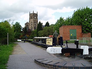
The Staffordshire and Worcestershire Canal is a navigable narrow canal in Staffordshire and Worcestershire in the English Midlands. It is 46 miles (74 km) long, linking the River Severn at Stourport in Worcestershire with the Trent and Mersey Canal at Haywood Junction by Great Haywood.
Rudyard is a lakeside village in the county of Staffordshire, England, west of Leek and on the shore of Rudyard Lake. Population details as taken at the 2011 census can be found under Horton.

Rutland Water is a reservoir in Rutland, England, east of Rutland's county town, Oakham. It is filled by pumping from the River Nene and River Welland, and provides water to the East Midlands. By surface area it is the largest reservoir in England, but its capacity is exceeded by that of Kielder Water in Northumberland. Its maximum depth is 33m.
Chasewater is a reservoir located in the parish of Burntwood and the district of Lichfield in Staffordshire, England. Originally known as Norton Pool and Cannock Chase Reservoir, it was created as a canal feeder reservoir in 1797. The reservoir was created to directly supply the Wyrley and Essington Canal and maintain levels in the 160-mile (260 km) Birmingham Canal Network. During a period of great industrial growth in the Black Country region the maintenance of water levels in canal infrastructure was essential and Chasewater was in great demand. As canals became less essential for transport of goods during the mid-20th century, the reservoir diversified and became a popular public amenity with activities such as water-skiing, sailing, wakeboarding and cycling. Chasewater is the third largest reservoir by volume in the county of Staffordshire and the largest canal feeder reservoir in the West Midlands.

The Hatherton Canal is a derelict branch of the Staffordshire and Worcestershire Canal in south Staffordshire, England. It was constructed in two phases, the first section opening in 1841 and connecting the main line to Churchbridge, from where a tramway connected to the Great Wyrley coal mines. The second section was a joint venture with the Birmingham Canal Navigations, and linked Churchbridge to the Cannock Extension Canal by a flight of 13 locks, which were opened with the Extension Canal in 1863. The coal traffic was very profitable, and the canal remained in use until 1949. It was formally abandoned in 1955, after which the Churchbridge flight and much of the Extension Canal were destroyed by open cast mining.

The Bittell Reservoirs are located in Worcestershire between Barnt Green to the south and the Birmingham district of Longbridge to the north. They consist of the Upper and Lower reservoir. They were built to feed the Worcester and Birmingham Canal, which was finished in the 1790s, however, the reservoir was not completed until 1837. The 'Upper' reservoir is to ensure that the level of the canal is kept sufficiently high, even in times of drought. The 'Lower' reservoir(s) are compensatory reservoirs to ensure that the local area does not become parched in dry times.

The Payette River is an 82.7-mile-long (133.1 km) river in southwestern Idaho and is a major tributary of the Snake River.

Hollingworth Lake is a 130-acre (53 ha) reservoir at Smithy Bridge in Littleborough, Greater Manchester, England. It was originally built as the main water source for the Rochdale Canal, but developed as a tourist resort from the 1860s. Hotels were built around it, helped by the arrival of the railway in 1839, which brought day-trippers and weekend visitors from Manchester, Bradford and Leeds.

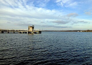
Lower Seletar Reservoir is a reservoir located in the northern part of Singapore in the Lower Seletar subzone, located in Yishun New Town. The reservoir has a surface area of 3.6 km², and a capacity of 9.5 million m³. The mean depth of the reservoir is 2 m, with a maximum depth of 5.5 m. The shoreline length is 14.3 km.

Rudyard Lake is a reservoir in Rudyard, Staffordshire, located north-west of the town of Leek, Staffordshire. It was constructed in the late 18th century to feed the Caldon Canal. During the 19th century, it was a popular destination for daytrippers taking advantage of easy access using the newly constructed North Staffordshire Railway. The lake is still used for many water activities such as boating, canoeing, fishing and also for walks and recreational steam train trips.
Ardingly Reservoir is west of Ardingly in West Sussex. The southern end is a 74.5-hectare (184-acre) Local Nature Reserve owned and managed by South East Water.

Carlyle Lake is a 25,000-acre (101.2 km2) reservoir largely located in Clinton County, Illinois, United States, with smaller portions of the lake within Bond and Fayette counties. It is the largest man-made lake in Illinois, and the largest lake wholly contained within the state.

Spruce Run Recreation Area is a 1,290-acre (5.2 km2) New Jersey state recreation area located in Union Township and Clinton Township in Hunterdon County, New Jersey, United States. It encompasses the Spruce Run Reservoir that is used as a backup reservoir to protect the state from prolonged droughts. The reservoir is the third largest in the state, after Round Valley and Wanaque Reservoir. The reservoir is used for recreation purposes, including hunting, fishing, boating and swimming.

Earlswood Lakes is the modern name for three man-made reservoirs which were built in the 1820s at Earlswood in Warwickshire, England, to supply water to the Stratford-upon-Avon Canal. They still supply the canal, and also provide leisure facilities, including sailing, fishing, and walking. The northern banks of the lakes form the borough and county boundary with the Metropolitan Borough of Solihull and the West Midlands.

Upper Tamar lake is a reservoir on the border of Cornwall and Devon in south-west England. It is owned by South West Water and managed by the South West Lakes Trust. The reservoir serves the water supply in the Bude area of Cornwall and surrounding districts, including Clovelly, Bradworthy and Warbstow.
Lower Tamar Lake is a 35 acre reservoir located on the Devon-Cornwall border, in England, near Thurdon.

Knypersley Reservoir near Biddulph, Staffordshire, England, was built in 1827 to supply water to the Caldon Canal, along with two others at Stanley Pool and Rudyard Lake.

Wish Stream is a small, steep English river, which is a tributary of the River Blackwater. The border between the counties of Berkshire and Surrey follows the course in the Camberley area. The stream rises on heath land to the north of Camberley and descends in a south-westerly direction, passing through the grounds of the Royal Military Academy Sandhurst. Two large lakes have been made before it leaves the grounds, to pass through a culvert under a retail park and bridges under major roads to discharge into the Blackwater.

