This article has multiple issues. Please help improve it or discuss these issues on the talk page . (Learn how and when to remove these messages)
|
Gaira | |
|---|---|
Town | |
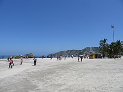 El Rodadero beach | |
 Gaira Location in Colombia | |
| Coordinates: 11°10′59″N74°13′01″W / 11.183°N 74.217°W | |
| Country | Colombia |
| Department | Magdalena |
| Population | - |
Gaira is a small town on the Caribbean coast of Colombia. Near the port of Santa Marta, it is also well known for El Rodadero, one of the most popular beaches in Colombia.

Gaira is located 7 km from Santa Marta city center, 10 km from Simón Bolívar International Airport which serves Santa Marta and the surrounding areas and is roughly 950 km north of the country's capital Bogotá. The town is considered a suburb of Santa Marta and its population is part of the overall population of Santa Marta although it is technically a different locality.
The town is served by the Ruta Nacional 90 which runs along the Caribbean Coast from the town of Turbo, Colombia in Antioquia Department all the way to the border with Venezuela east of Maicao in La Guajira Department approximately 272 km northeast of Gaira.
| | This Magdalena Department location article is a stub. You can help Wikipedia by expanding it. |