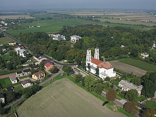
Gmina Nowa Sucha is a rural gmina in Sochaczew County, Masovian Voivodeship, in east-central Poland. Its seat is the village of Nowa Sucha, which lies approximately 9 kilometres south-west of Sochaczew and 57 km south-west of Warsaw.

Gorzewnica is a village in the administrative district of Gmina Brochów, within Sochaczew County, Masovian Voivodeship, in east-central Poland. It lies approximately 10 kilometres (6 mi) north-east of Brochów, 19 km (12 mi) north-east of Sochaczew, and 46 km (29 mi) west of Warsaw.
Giżyczki is a village in the administrative district of Gmina Iłów, within Sochaczew County, Masovian Voivodeship, in east-central Poland. It lies approximately 6 kilometres (4 mi) south-east of Iłów, 14 km (9 mi) north-west of Sochaczew, and 64 km (40 mi) west of Warsaw.
Suchodół is a village in the administrative district of Gmina Iłów, within Sochaczew County, Masovian Voivodeship, in east-central Poland. It lies approximately 6 kilometres (4 mi) north-west of Iłów, 24 km (15 mi) north-west of Sochaczew, and 71 km (44 mi) west of Warsaw.
Kamion is a village in the administrative district of Gmina Młodzieszyn, within Sochaczew County, Masovian Voivodeship, in east-central Poland. It lies approximately 6 kilometres (4 mi) north of Młodzieszyn, 14 km (9 mi) north of Sochaczew, and 57 km (35 mi) west of Warsaw.
Kozłów Biskupi is a village in the administrative district of Gmina Nowa Sucha, within Sochaczew County, Masovian Voivodeship, in east-central Poland. It lies approximately 5 kilometres (3 mi) north-east of Nowa Sucha, 5 km (3 mi) south-west of Sochaczew, and 55 km (34 mi) west of Warsaw.
Złota is a village in the administrative district of Gmina Rybno, within Sochaczew County, Masovian Voivodeship, in east-central Poland. It lies approximately 4 kilometres (2 mi) south of Rybno, 12 km (7 mi) west of Sochaczew, and 63 km (39 mi) west of Warsaw.
Dachowa is a village in the administrative district of Gmina Sochaczew, within Sochaczew County, Masovian Voivodeship, in east-central Poland. It lies approximately 3 kilometres (2 mi) south-west of Sochaczew and 55 km (34 mi) west of Warsaw.
Mokas is a village in the administrative district of Gmina Sochaczew, within Sochaczew County, Masovian Voivodeship, in east-central Poland. It lies approximately 9 kilometres (6 mi) north-east of Sochaczew and 47 km (29 mi) west of Warsaw.
Dębówka is a village in the administrative district of Gmina Teresin, within Sochaczew County, Masovian Voivodeship, in east-central Poland. It lies approximately 6 kilometres (4 mi) south-west of Teresin, 10 km (6 mi) south-east of Sochaczew, and 45 km (28 mi) west of Warsaw.
Lisice is a village in the administrative district of Gmina Teresin, within Sochaczew County, Masovian Voivodeship, in east-central Poland. It lies approximately 5 kilometres (3 mi) east of Teresin, 17 km (11 mi) east of Sochaczew, and 36 km (22 mi) west of Warsaw.
Ludwików is a village in the administrative district of Gmina Teresin, within Sochaczew County, Masovian Voivodeship, in east-central Poland. It lies approximately 17 kilometres (11 mi) east of Sochaczew and 37 km (23 mi) west of Warsaw.
Paprotnia is a village in the administrative district of Gmina Teresin, within Sochaczew County, Masovian Voivodeship, in east-central Poland. It lies approximately 2 kilometres (1 mi) north-east of Teresin, 14 km (9 mi) east of Sochaczew, and 39 km (24 mi) west of Warsaw.
Pawłówek is a village in the administrative district of Gmina Teresin, within Sochaczew County, Masovian Voivodeship, in east-central Poland. It lies approximately 7 kilometres (4 mi) south of Teresin, 14 km (9 mi) south-east of Sochaczew, and 43 km (27 mi) west of Warsaw.
Pawłowice is a village in the administrative district of Gmina Teresin, within Sochaczew County, Masovian Voivodeship, in east-central Poland. It lies approximately 16 kilometres (10 mi) east of Sochaczew and 37 km (23 mi) west of Warsaw.
Skrzelew is a village in the administrative district of Gmina Teresin, within Sochaczew County, Masovian Voivodeship, in east-central Poland. It lies approximately 15 kilometres (9 mi) south-east of Sochaczew and 43 km (27 mi) west of Warsaw.
Strugi is a village in the administrative district of Gmina Teresin, within Sochaczew County, Masovian Voivodeship, in east-central Poland. It lies approximately 11 kilometres (7 mi) south-east of Sochaczew and 46 km (29 mi) west of Warsaw.
Szymanów is a village in the administrative district of Gmina Teresin, within Sochaczew County, Masovian Voivodeship, in east-central Poland. It lies approximately 13 kilometres (8 mi) south-east of Sochaczew and 43 km (27 mi) west of Warsaw.

Teresin is a village in Sochaczew County, Masovian Voivodeship, in east-central Poland. It is the seat of the gmina called Gmina Teresin. It lies approximately 13 kilometres (8 mi) east of Sochaczew and 40 km (25 mi) west of Warsaw.


