Haflong is a town and headquarters of Dima Hasao district in the state of Assam in India. It is the only hill station in Assam.
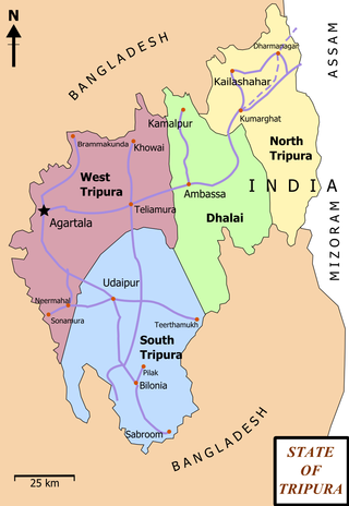
Ambassa is a census town located in the Indian state of Tripura a Municipal Council in Dhalai district. Ambassa is also the headquarters of the Dhalai district.
Khowai is a town located in the Indian state of Tripura and a Municipal Council in Khowai district. The city lies on the banks of Khowai river and hence from the river the city gets its name. It was originally settled upon by Upendranath Roy. Located near the Bangladesh border, Khowai has boundaries with Bangladesh on its entire southern part.
Badharghat is a census town in West Tripura district in the state of Tripura, India.
Belonia is a town and municipal council in South Tripura district, Tripura, India. It is also the headquarters of South Tripura District. It is linked with Agartala by National Highway 108A from Belonia to Jolaibari and via National Highway 8 from Jolaibari to Agartala. Belonia lies on the border with Bangladesh.
Indranagar is a census town in West Tripura district in the Indian state of Tripura. The locality is famous for the Kali temple. Everyday many devotees are found to offer worship to the goddess Kali. During Dewali a fair is held for three days. Large gathering is observed. ITI is another landmark of the place.
Jogendranagar is a census town in West Tripura district in the Indian state of Tripura. Jogendranagar has the only railway station after Agartala railway station, in Agartala.
Kamalpur is a town and a Nagar Panchayat in Dhalai District in the Indian state of Tripura around 93 km from the state capital Agartala. It is the largest Sub-divisional town in Dhalai District.
Kunjaban is a census town in West Tripura district in the Indian state of Tripura.
Mamit is a census town in Mamit district in the Indian state of Mizoram. Mamit emerged from the regrouping of villages.

Mudigere is a Town Panchayath and Taluk in Chikkamagaluru district in the Indian state of Karnataka. It is 30 km from the district headquarters.
Ranirbazar is a town and a Municipal Council in West Tripura district in the Indian state of Tripura.
Sabroom is a town and a Nagar Panchayat in South Tripura district in the Indian state of Tripura. It is located on the banks of the Feni River, which separates India and Bangladesh. Most of the population speak Noakhailla. It is believed that during the Bangladesh War of Independence in 1971, the Hindu society people migrated to Sabroom from Noakhali and Feni districts of Bangladesh.
Sonamura is a town and a Nagar Panchayat in the Indian state of Tripura. It is the headquarter of Sonamura Subdivision in Sipahijala district and lies on the border with Bangladesh to the east of Comilla.
Teliamura is a town and a Municipal Council in Khowai district in the Indian state of Tripura. It is on National Highway No. 08 of India. It is also the headquarters of the recently included sub-division of Teliamura. It is 45 km from Agartala, Capital of Tripura, 35 km from Khowai and 42 km from Ambassa.
Narsingarh is a census town in West Tripura district in the Indian state of Tripura.
Pratapgarh is a census town in West Tripura district in the Indian state of Tripura.
Kerur is a town in Bagalkot district in Karnataka, which located on NH 218. It has an average elevation of 617 meters (2024 feet). It's the birthplace of Jagadish Shettar, a former Chief Minister of Karnataka. Kerur is a Town Panchayat city in the district of Bagalkot, Karnataka. The Kerur city is divided into 16 wards for which elections are held every five years. The Kerur Town Panchayat has a population of 19,731 of which 9,929 are males while 9,802 are females as per report released by Census India 2011.
Gandhigram is a town in Tripura, India. located around 10 km from city centre Agartala. It comes under Sadar district. It has an old age home called Sandhyoneer.
Santirbazar is a town and Municipal Council in South Tripura district, Tripura, India. It is linked with Agartala by National Highway 8 via Udaipur and Bishramganj to Sabroom.