
Bellingham is the county seat of Whatcom County in the U.S. state of Washington. It lies 21 miles (34 km) south of the U.S.–Canada border, between Vancouver, British Columbia, 52 miles (84 km) to the northwest and Seattle 90 miles (140 km) to the south.

Whatcom County is a county located in the northwestern corner of the U.S. state of Washington, bordered by the Lower Mainland of British Columbia to the north, Okanogan County to the east, Skagit County to the south, San Juan County across Rosario Strait to the southwest, and the Strait of Georgia to the west. Its county seat and largest population center is the coastal city of Bellingham. Whatcom County is coterminous with the Bellingham, WA Metropolitan Statistical Area. As of the 2020 census, the county's population was 226,847.

Whiteface Mountain is the fifth-highest mountain in the U.S. state of New York, and one of the High Peaks of the Adirondack Mountains, located in the town of Wilmington in Essex County. Set apart from most of the other High Peaks, the summit offers a 360-degree view of the Adirondacks and clear-day glimpses of Vermont and Canada, where Montreal can be seen on a very clear day. Because of its relative isolation, the mountain is exposed to prevailing winds from the west and frequently capped with snow and ice, making it an area of interest to meteorologists. Weather data has been collected on the summit since 1937. The mountain's east slope is home to a major ski area which boasts the greatest vertical drop east of the Rockies, and which hosted the alpine skiing competitions of the 1980 Winter Olympics. Unique among the High Peaks, Whiteface features a developed summit and seasonal accessibility by motor vehicle. The Whiteface Veterans Memorial Highway reaches a parking area at an elevation shortly below the summit, with the remaining distance covered by tunnel and elevator. The peak can also be reached on two hiking trails.
Silver Star Mountain Resort is a ski resort located near Silver Star Provincial Park in the Shuswap Highland of the Monashee Mountains, 22 km northeast of the city of Vernon, British Columbia, Canada. Silver Star's snow season runs from late November to mid-April, weather permitting. Silver Star provides summer lift access for mountain biking and hiking from the end of June through September.
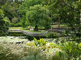
Mount Coot-tha is a mountain and a suburb of the City of Brisbane, Queensland, Australia. Visible from much of the city, Mount Coot-tha is a popular bushland tourist destination including the Mount Coot-tha Lookout, Brisbane Botanic Gardens and Sir Thomas Brisbane Planetarium, as well as a mountain drive, bike trails, parks including a waterfall, and television and radio towers. In the 2021 census, Mount Coot-tha had a population of 0 people.

Bellingham International Airport is three miles (5 km) northwest of Bellingham, in Whatcom County, Washington, United States. BLI covers 2,190 acres (886 ha) of land, and is the third-largest commercial airport in Washington.
Pajarito Mountain Ski Area (Pajarito) is located on the north face of Pajarito Mountain, one of the Jemez Mountains in north central New Mexico, west of Los Alamos. It is located on 850 acres (3.4 km2) of privately owned land. Pajarito Mountain is owned and operated by volunteers and Mountain Capital Partners. A typical season runs from Christmas to early April, but an outstanding season may run from Thanksgiving to late April. Pajarito now has a snowmaking system and it is producing snow. Season passes are available with discounts available for early season purchase.

The International Mountain Bicycling Association (IMBA) is a non-profit educational association that aims to create and preserve trails for mountain bikers worldwide. The IMBA promotes mountain biking, trail building, and trail maintenance. The IMBA has developed a set of principles known as the "Rules of the Trail", which promote responsibility on shared-use and single track trails.

Alafia River State Park is a Florida State Park, located near Picnic in Hillsborough County in central Florida, 17 miles southeast of Tampa on County Road 39. Even before it became a park, the area, and particularly Hurrah Lake, was the center of leisure activities since the early 1880s.

Lummi Island lies at the southwest corner of Whatcom County, Washington, United States, between the mainland part of the county and offshore San Juan County. The Lummi Indian Reservation is situated on a peninsula east of the island, but it does not include Lummi Island. The island has a land area of 23.97 square kilometres and had a population of 822 as of the 2000 census. The population nearly doubles in summer when second-home owners from Canada and the U.S. arrive for the summer months.

Whatcom Falls Park is a 241-acre (0.98 km2) park in Bellingham, Washington, United States. The falls are on Whatcom Creek, which leads from Lake Whatcom to Bellingham Bay. The park has four sets of waterfalls and several miles of well maintained walking trails.

Mount Tamalpais and the surrounding areas in Marin County, California are recognized as the birthplace of the modern mountain biking industry. Other Northern California hill-adjacent suburban areas had small cohorts.

Larrabee State Park is a public recreation area located on Samish Bay on the western side of Chuckanut Mountain, 6 mi (9.7 km) south of the city of Bellingham, Washington. It was created in 1915 as Washington's first state park. The park covers 2,748 acres (1,112 ha) and features fishing, boating, and camping as well as mountain trails for hiking and biking. It is managed by the Washington State Parks and Recreation Commission.

Burke Mountain is a mountain located in the Northeast Kingdom of Vermont. The bulk of the mountain is in Burke and Kirby, Caledonia County, but its southeast side is in Essex County. It is flanked to the east and southeast by Umpire Mountain and Kirby Mountain, respectively.

Lookout Mountain is a foothill on the eastern flank of the Front Range of the Rocky Mountains of North America. The 7,377-foot (2,249 m) peak is located in Lookout Mountain Park, 1.7 miles (2.7 km) west-southwest of downtown Golden in Jefferson County, Colorado, United States.
The Ski to Sea Race (S2S), widely known as the Ski to Sea, is a seven-legged, 93-mile (150 km) long, multi-event competition held on the Sunday of Memorial Day weekend in Whatcom County. The race starts on the ski slopes of Mount Baker Ski Area, and ends at Marine Park in Fairhaven, on the shore of Bellingham Bay. The seven legs of the race are cross-country skiing, downhill skiing or snowboarding, running, road biking, canoeing, cyclo-cross biking, and kayaking. The Ski to Sea Race is managed by Whatcom Events, with a race committee that includes a race director, an operations assistant, one or two chairmen to oversee each event, a volunteer coordinator along with nearly 900 volunteers.

Located in the southeastern section of Manchester, Connecticut, the Case Mountain Recreational Area encompasses 640 acres (2.6 km2) of combined open space and watershed land stretching from the Glastonbury border north to Case Pond. Some trails lead south across the Glastonbury border to a larger area of land owned by the Town of Manchester to maintain the Buckingham Reservoir and provide drinking water to Manchester. The land around the reservoir is open to recreation. While there is a hill named Case Mountain in this area, locals refer to this entire trail system and forest in Manchester and Glastonbury simply as “Case Mountain.”
The Balm-Boyette Scrub Nature Preserve is a 5,723-acre (2,316 ha) preserve located in Hillsborough County, Florida. It was purchased through joint funding from the County's Environmental Lands Acquisition and Protection Program (ELAPP) and the State of Florida's Conservation and Recreation Lands (CARL) Program. While it consists largely of abandoned phosphate pits, it has a large area of undisturbed scrub habitat. Natural habitats within the site include sand pine scrub, xeric oak scrub, pine flatwoods, hardwood hammock, wet prairie, freshwater marsh, cypress swamp, and hardwood swamp. During the 1960s the land was pitted with phosphate mines. The natural waterflow had been altered from its original state into a series of stagnant pools. In 2016, a project was undertaken under the umbrella of Swiftmud's Surface Water Improvement and Management, or SWIM, program. The project will create a "habitat mosaic" with habitat for wading birds as well as upland creatures.
The Whatcom Parks and Recreation Foundation (WPRF) is a 501(c)3 non-profit organization operating in Whatcom County, Washington. The mission of the Whatcom Parks and Recreation Foundation is to encourage public and private support for parks and recreation projects within Whatcom County. It serves as a trust for privately donated park funding, as a fiscal sponsor for smaller groups of park advocates, and promotes its own initiatives within the community. Ex Officio members on the Board of Directors represent all of the city parks departments and park districts in Whatcom County, including Bellingham, Lynden, Blaine, Northwest Park District and Whatcom County Parks and Recreation.

The Sourdough Mountain Lookout is a fire lookout that was built by the Civilian Conservation Corps in 1933. Constructed atop Sourdough Mountain in North Cascades National Park, in the U.S. state of Washington, the lookout was placed on the National Register of Historic Places in 1989.

