Gallitzin is a borough in Cambria County, Pennsylvania, United States. It is bordered by Gallitzin Township and Tunnelhill, all of which sit astride the Eastern continental divide. Tunnel Hill and Gallitzin both are pierced by railroad tunnels shortening the necessary ascent for rails crossing the Allegheny Front onto the Allegheny Plateau which encompasses the towns' terrains. Topping the gaps of the Allegheny, the area is one of only five major breaks in the Appalachians allowing east–west transportation corridors before the advent of 20th century technologies.
Portage is a borough with home rule status in Cambria County, Pennsylvania, United States. It is 10 miles (16 km) southeast of Ebensburg and 22 miles (35 km) southwest of Altoona. It is part of the Johnstown, Pennsylvania Metropolitan Statistical Area. The population was 2,638 at the 2010 US census.

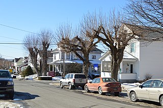
Wilmore is a borough in Cambria County, Pennsylvania, United States. It is part of the Johnstown, Pennsylvania Metropolitan Statistical Area. The population was 225 at the 2010 census.
The Pennsylvania Railroad, legal name The Pennsylvania Railroad Company, also known as the "Pennsy", was an American Class I railroad that was established in 1846 and headquartered in Philadelphia, Pennsylvania. At its peak in 1882, the Pennsylvania Railroad was the largest railroad, the largest transportation enterprise, and the largest corporation in the world.

The Horseshoe Curve is a three-track railroad curve on Norfolk Southern Railway's Pittsburgh Line in Blair County, Pennsylvania. The curve is roughly 2,375 feet (700 m) long and 1,300 feet (400 m) in diameter. Completed in 1854 by the Pennsylvania Railroad as a way to reduce the westbound grade to the summit of the Allegheny Mountains, it replaced the time-consuming Allegheny Portage Railroad, which was the only other route across the mountains for large vehicles. The curve was later owned and used by three Pennsylvania Railroad successors: Penn Central, Conrail, and Norfolk Southern.

The Allegheny Portage Railroad was the first railroad constructed through the Allegheny Mountains in central Pennsylvania. It operated from 1834 to 1854 as the first transportation infrastructure through the gaps of the Allegheny that connected the midwest to the eastern seaboard across the barrier range of the Allegheny Front. Approximately 36 miles (58 km) long overall, both ends connected to the Pennsylvania Canal, and the system was primarily used as a portage railway, hauling river boats and barges over the divide between the Ohio and the Susquehanna Rivers. Today, the remains of the railroad are preserved within the Allegheny Portage Railroad National Historic Site operated by the National Park Service.

The Lehigh Line Connection connects Amtrak's Northeast Corridor (NEC) with the Conrail Lehigh Line 2 miles (3.2 km) south of downtown Newark, New Jersey. It leaves the NEC at Hunter Interlocking, and the line is sometimes called the Hunter Connection. Used by New Jersey Transit (NJT) Raritan Valley Line trains since 1997 when it replaced an older connection, it splits from the NEC just north of the former connector, with wider radius curves with a maximum speed of 45 mph, compared to the 15 mph of the original alignment.

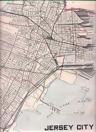
Marion Junction is a railroad junction in western Jersey City, New Jersey. Currently, it connects CSX's River Line to Conrail's Passaic and Harsimus Line. The two lines merge towards the west, allowing through trains from upstate New York to continue towards the rest of the country. The track actually making the connection is known as the Marion Running Track.

The Passaic and Harsimus Line, part of Conrail Shared Assets Operations, serves freight in northeastern New Jersey. It takes trains from the Northeast Corridor and Lehigh Line near Newark Liberty International Airport northeast and east into Jersey City. It is part of CSX's main corridor from upstate New York to the rest of the east coast.

The Laurel Highlands is a region in southwestern Pennsylvania made up of Fayette County, Somerset County, and Westmoreland County. It has a population of about 600,000 people.

The Baltimore and Potomac Railroad (B&P) operated from Baltimore, Maryland, southwest to Washington, D.C., from 1872 to 1902. Owned and operated by the Pennsylvania Railroad, it was the second railroad company to connect the nation's capital to the Northeastern U.S., and competed with the older Baltimore and Ohio Railroad.
The Pittsburgh, Fort Wayne and Chicago Railway was a major part of the Pennsylvania Railroad system, extending the PRR west from Pittsburgh, Pennsylvania, via Fort Wayne, Indiana, to Chicago, Illinois. It included the current Norfolk Southern-owned Fort Wayne Line east of Crestline, Ohio, to Pittsburgh, and the Fort Wayne Secondary, owned by CSX, from Crestline west to Tolleston in Gary, Indiana. CSX leased its entire portion in 2004 to the Chicago, Fort Wayne and Eastern Railroad (CFE). The remaining portion of the line from Tolleston into Chicago is now part of the Norfolk Southern's Chicago District, with a small portion of the original PFW&C trackage abandoned in favor of the parallel lines of former competitors which are now part of the modern NS system.

The Harrisburg Subdivision is a railroad line owned by CSX Transportation in Pennsylvania. The line is located in Philadelphia, and connects Greenwich Yard and the Philadelphia Subdivision with the Trenton Subdivision along a former Pennsylvania Railroad line. Much of the Harrisburg Subdivision is the High Line' or West Philadelphia Elevated along 31st Street over the 30th Street Station area.

The Main Line of the Pennsylvania Railroad was a rail line in Pennsylvania connecting Philadelphia with Pittsburgh via Harrisburg. The rail line was split into two rail lines, and now all of its right-of-way is a cross-state corridor, composed of Amtrak's Philadelphia to Harrisburg Main Line and the Norfolk Southern Railway's Pittsburgh Line.
The Fort Wayne Line and Fort Wayne Secondary is a rail line owned and operated by the Norfolk Southern Railway (NS), Chicago, Fort Wayne and Eastern Railroad (CFE), and CSX Transportation in Pennsylvania, Ohio, and Indiana. The line runs from Pittsburgh, west via Fort Wayne, Indiana, to Gary, Indiana, along what was once the Pennsylvania Railroad's Pittsburgh to Chicago main line.

The Pennsylvania Canal, sometimes known as the Pennsylvania Canal system, was a complex system of transportation infrastructure improvements, including canals, dams, locks, tow paths, aqueducts, and viaducts. The canal was constructed and assembled over several decades beginning in 1824, the year of the first enabling act and budget items.
National Docks Secondary is a freight rail line within Conrail's North Jersey Shared Assets Area in Hudson County, New Jersey, used by CSX Transportation. It provides access for the national rail network to maritime, industrial, and distribution facilities at Port Jersey, the Military Ocean Terminal at Bayonne (MOTBY), and Constable Hook as well as carfloat operations at Greenville Yard. The line is an important component in the planned expansion of facilities in the Port of New York and New Jersey. The single track right of way comprises rail beds, viaducts, bridges, and tunnels originally developed at the end of the 19th century by competing railroads.
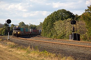
The Pittsburgh Line is the Norfolk Southern Railway's primary east–west artery in its Pittsburgh Division and Harrisburg Division across the U.S. state of Pennsylvania and is part of the Keystone Corridor, Amtrak-Norfolk Southern's combined rail corridor.

Muleshoe Curve is a curve of track used by the former Pennsylvania Railroad (PRR) near Duncansville, Pennsylvania. Part of a secondary and frequently disused route, the curve is less well known than Horseshoe Curve, located 4.34 mi north.
Thomas W. Seabrook was a 19th-century American civil engineer who was most known for his work on the construction and extension of the Pennsylvania Railroad.
