
Tezpur is a city and urban agglomeration in Sonitpur district, Assam state, India. Tezpur is located on the banks of the river Brahmaputra, 175 kilometres (109 mi) northeast of Guwahati, and is the largest of the north bank cities with a population of 1,40,000 as per Metropolitan Census 2023.

Nalbari is an administrative district in the state of Assam in India. The district headquarters is located at Nalbari.Th

Sonitpur district [Pron: ˌsə(ʊ)nɪtˈpʊə or ˌʃə(ʊ)nɪtˈpʊə] is an administrative district in the state of Assam in India. The district headquarters is located at Tezpur.

The Asam Sahitya Sabha is a non Government, non profit, literary organisation of Assam. It was founded in December 1917 in Assam, India to promote the culture of Assam and Assamese literature. A branch of the organisation named Singapore Sahitya Sabha was launched in Singapore on July 28, 2019.
Dhemaji district is an administrative district in the state of Assam in India. The district headquarters are located at Dhemaji and commercial headquarters being located Silapathar. The district occupies an area of 3237 km² and has a population of 686,133. Main religions are Hindus 548,780, Muslims 10,533, Christians 6,390.
Basugaon (IPA:ˈbɑːsʊˌgɑ̃ʊ) is a Town in Chirang District of Assam, India. The name of this town is derived from its high bamboo plantation and bamboo market basically "basu" or "bash" means bamboo and "gaon" means village that is Basugaon, 'The village of bamboo'. It is an industrial town and a Municipal Board area. It is a neighbourhood of Bongaigaon UA, and it is situated approximately 180 km from Guwahati City in the western part of the Lower Assam Region.
Howly (IPA:ˈhaʊlɪ) is a town and a municipality in Barpeta district in the Indian state of Assam.

Silapathar is a city in Dhemaji district in the Indian state of Assam. The city is on the northern bank of the Brahmaputra River and is 470 kilometres (290 mi) from the city of Guwahati and just six km (3.7 mi) from border of Arunachal Pradesh. The longest rail cum road bridge in India connects Silapathar to Dibrugarh. Historical Malinithan mandir is located around ten km (6.2 mi) from Silapathar.
Sonari is a district Headquarter, mid-size town and a municipal board in newly announced Charaideo district in the Indian state of Assam.

Baksa district is an administrative district in the Bodoland Territorial Region of Assam, one of the North-Eastern states of India. The administrative headquarters is at Mushalpur. Manas National Park is a part of this district.

Udalguri district (Pron:ˌʊdʌlˈgʊəri), also known as Odalguri, is a district in the Bodoland Territorial Region of the state of Assam in Northeastern India. Udalguri town is the headquarters of the district.
Narayanpur is a town located in Lakhimpur district of the northeastern Indian state Assam. It falls under Bihpuria constituency of Assam Legislative Assembly and under Narayanpur Police Station. Narayanpur is also the name of the development block. It is located between Dholpur and Bihpuria. Narayanpur is famous as birthplace of Madhavdev.

Hem Barua was an Indian independence activist, social worker and writer from Sonitpur district of the Indian state of Assam. For his remarkable works to the people of Assam, he is called Tyagbir (ত্যাগবীৰ).
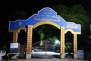
Tyagbir Hem Baruah College is an institution for higher education located in Jamugurihat in Naduar area under Sonitpur district of Assam, India. The college was established in 1963. The college is named after Tyagbir Hem Barua, a noted Indian independence activist, social worker and writer of Assam.
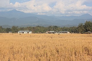
Jamugurihat is a town and a town area committee in Sonitpur district, in the Indian state of Assam. This is a newly planned city area by the Urban Development Authority of Assam. The town is located north of the Brahmaputra River. It is the location of the 200-year-old Baresahariya Bhaona festival.
Panchigaon is a village in Sonitpur district, in the state of Assam in India. The village is located at the north bank of Brahmaputra River towards the town of Jamugurihat.

Bhuragaon ( is the name of a town in the Indian state of Assam. Bhuragaon is located in Bhuragaon Tehsil of Morigaon district. Bhuragaon is situated on the south bank of the Brahmaputra.
Sootea is located under Naduar revenue circle, under Tezpur sub-division, formerly in the district of Sonitpur but at present in the district of Biswanath, Assam state, India.

The Nagsankar Temple is a famous shrine situated in nagsankar mouza near sootea, to the east of Tezpur, in Sonitpur District of Assam. The temple is believed to be built by King Narasankar of Nagakha in the 4th century.
Chatia College is an institution for higher education located in Sootea in Naduar area under Biswanath district of Assam, India. The college was established in 1982.

