Gams bei Hieflau | |
|---|---|
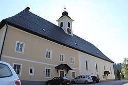 Gams bei Hieflau parish church | |
 Coat of arms | |
 Gams bei Hieflau Location within Austria | |
| Coordinates: 47°40′00″N14°48′00″E / 47.66667°N 14.80000°E | |
| Country | Austria |
| State | Styria |
| District | Liezen |
| Area | |
• Total | 46.23 km2 (17.85 sq mi) |
| Elevation | 539 m (1,768 ft) |
| Population (1 January 2021) | |
• Total | 504 |
| • Density | 11/km2 (28/sq mi) |
| Time zone | UTC+1 (CET) |
| • Summer (DST) | UTC+2 (CEST) |
| Postal code | 8922 |
| Area code | +43 3637 |
| Vehicle registration | LI |
Gams bei Hieflau is a former municipality in the district of Liezen in the Austrian state of Styria. Since the 2015 Styria municipal structural reform, it is part of the municipality Landl. [1]