Conception Harbour is a town on the Avalon Peninsula in Newfoundland and Labrador, Canada. It is in Division 1 on Conception Bay and can be accessed via Newfoundland and Labrador Route 60.
Clarenville is a town on the east coast of Newfoundland in the province of Newfoundland and Labrador, Canada. Clarenville was incorporated in 1951. It is located in the Shoal Harbour valley, fronting an arm of the Atlantic Ocean called Random Sound.
Appleton is a town in the northeastern part of Newfoundland in the province of Newfoundland and Labrador, Canada.

Glenwood is a town in northeastern Newfoundland, Newfoundland and Labrador, Canada. It is in Division No. 6 on Gander Lake.

Division 1, Newfoundland and Labrador is a census division covering the entire Avalon Peninsula including the Isthmus of Avalon of the Canadian province of Newfoundland and Labrador. Like all census divisions in Newfoundland and Labrador, but unlike the census divisions of some other provinces, the division exists only as a statistical division for census data, and is not a political entity.

Twillingate is a town of 2,121 people located on the Twillingate Islands ("Toulinquet") in Notre Dame Bay, off the north eastern shore of the island of Newfoundland in the province of Newfoundland and Labrador, Canada. The town is about 100 kilometres (62 mi) north of Lewisporte and Gander.

Area code 709 is the telephone area code in the North American Numbering Plan (NANP) for the entire Canadian province of Newfoundland and Labrador.

Boyd's Cove, also known as Boyd's Harbour, is a local service district and designated place in the Canadian province of Newfoundland and Labrador that is near Lewisporte. There is an interpretive centre dedicated to the earlier indigenous Beothuk settlement at this location.
Virgin Arm–Carter's Cove is a local service district and designated place on New World Island in the Canadian province of Newfoundland and Labrador. Virgin Arm-Carter's Cove is located approximately 90 km Northwest of Gander in Subdivision H of Division No. 8.
Nova Central School District was a school district headquartered in Gander in the Canadian province of Newfoundland and Labrador. The district had 66 schools located in 50 different communities, and served about 13,000 students, including a significant rural population. The District was formed by the merger of the Lewisporte-Gander and Baie Verte-Central-Connaigre school boards in 2004. The largest school in the district was Gander Academy. The district was replaced by the Newfoundland and Labrador English School District upon provincial amalgamation in 2013.

The East Coast Trail (ECT) is a long-distance coastal footpath located in the Canadian province of Newfoundland and Labrador. It is a developed trail over 336 kilometres (209 mi) long, creation of which began in 1994. It is made up of 25 linked wilderness paths and passes through more than 30 communities. It was named one of the best adventure destinations by National Geographic in 2012 and is extended and improved yearly.
Musgrave Harbour is a town and designated place in the Canadian province of Newfoundland and Labrador.

Nipper's Harbour is a town located on the east coast of the Baie Verte Peninsula of Newfoundland in the Canadian province of Newfoundland and Labrador. This incorporated community of 85 people is located on a rocky inlet that combines Nipper's Harbour and Noble's Cove, and where the primary industry is the inshore fishery. The town is approximately 58 km from Baie Verte.

Route 330, also known as Road to the Shore or more commonly Gander Bay Road, is a highway that extends from Gander, Newfoundland across "the loop" passing through towns such as Gander Bay South, Carmanville, Musgrave Harbour, and Lumsden to New-Wes-Valley. Here, the highway connects with Route 320, which continues "the loop" down the west shore of Bonavista Bay exiting back to the Trans-Canada Highway in Gambo.
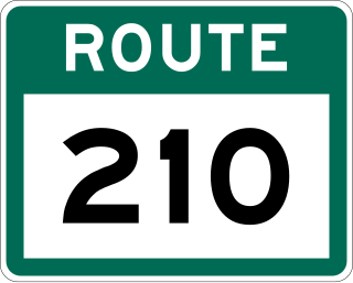
Route 210, also known as the Burin Peninsula Highway and Heritage Run, is a highway that extends through the Burin Peninsula from Goobies to Grand Bank, Newfoundland and Labrador. The maximum speed limit is 90 km/h except through communities and settlements where the speed limit is reduced to 50 km/h. Just after exiting Swift Current, until a few kilometres north of Marystown, much of the landscape is barren, with very few trees prevalent. After entering Marystown, motorists approach a junction where they could turn right to continue their journey on Route 210 until arriving at Grand Bank, or going straight onto Route 220 towards Burin and St. Lawrence. Marystown is the most populous community along the route.
South River is an incorporated municipality in the Canadian province of Newfoundland and Labrador, located at the south-southeast side of Bay de Grave, in Conception Bay. The town had a population of 674 according to the 2021 Canadian Census. South River is the site of the western terminus of Newfoundland and Labrador Route 60, also known as the Conception Bay Highway, which proceeds eastward to downtown St. John's. The river itself forms a natural boundary with neighbouring Clarke's Beach and is a scheduled salmon river. A second river, known as the Gould Brook, forms another natural boundary with the unincorporated local service district of Makinsons. South River is home to the Bay de Grave Regional Fire Department, a first step in developing successful regional cooperation amongst municipalities.
New Harbour is a local service district and designated place in the Canadian province of Newfoundland and Labrador. It is on the east shore of Trinity Bay, along Provincial Route 80. Route 80's intersection with Route 73 is inside New Harbour.

Division No. 1, Subdivision G is an unorganized subdivision on the Avalon Peninsula in Newfoundland and Labrador, Canada. It is in Division 1 and contains the unincorporated communities of Baccalieu Island, Besom Cove, Bradley's Cove, Burnt Point, Caplin Cove, Daniel's Cove, Grates Cove, Gull Island, Job's Cove, Kingston, Long Beach, Lower Island Cove, Low Point, Northern Bay, Ochre Pit Cove, Red Head Cove, Riverhead, Smooth Cove and Western Bay.
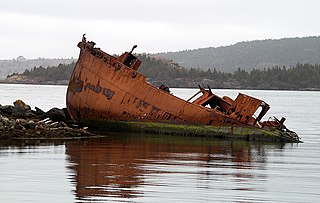
The Straight Shore is a 45-kilometre (28 mi) section of coastline on the island of Newfoundland in Newfoundland and Labrador, Canada. It follows a generally northwesterly direction from the town of Cape Freels to Musgrave Harbour and then a generally westerly direction along the southern shore of Sir Charles Hamilton Sound to Gander Bay. The entire section known as the Straight Shore is not entirely straight especially the more westerly section from Musgrave Harbour to Gander Bay South. The name may have been derived from the stretch of sandy beaches along the stretch between Cape Freels and Musgrave Harbour. The name stayed and was extended to include the section from Musgrave Harbour to Gander Bay South. Route 330 follows along the geographic area of the Straight Shore.

