Garden of the Provinces and Territories

Last updated
Garden of the Provinces and Territories

Garden of the Provinces and Territories 2007.jpg

The concrete slab structure representing the Great Lakes in the Garden of the Provinces and Territories
Type Public garden
Location Wellington Street at Bay Street, Ottawa, ON, Canada
Coordinates 45°25′06″N75°42′32″W / 45.418358°N 75.708858°W / 45.418358; -75.708858 Coordinates: 45°25′06″N75°42′32″W / 45.418358°N 75.708858°W / 45.418358; -75.708858
Area 4 acres (1.6 ha)
Opened September 25, 1962 (1962-09-25)
Designer Don W. Graham
Operated by Government of Canada

The Garden of the Provinces and Territories is a 4-acre (1.6 ha) site along Confederation Boulevard in Ottawa, Ontario, Canada's capital city. It is bounded by the Sparks Street escarpment on the south, Wellington Street on the west and north, and Bay Street to the east [1] between Christ Church Cathedral and the Library and Archives Canada. It was officially opened on September 25, 1962, as a western gateway to the Parliament Buildings. [1] The park was renamed from "Garden of the Provinces" on October 6, 2005 to recognize and include Canada's three territories. [1] Scott Brison, then the Minister of Public Works and Government Services Canada, officially renamed the park.

Confederation Boulevard is a "ceremonial and discovery route" in Canada's National Capital Region, running through Parliament Hill and encompassing downtown areas in Ottawa and Gatineau. Some of Canada's most important institutions and landmarks lie along its route. During state visits, Confederation Boulevard is toured by foreign dignitaries. On Canada Day, much of Confederation Boulevard is closed to cars. Confederation Boulevard is an initiative of the National Capital Commission (NCC).

Ottawa Federal capital city in Ontario, Canada

Ottawa is the capital city of Canada. It stands on the south bank of the Ottawa River in the eastern portion of southern Ontario. Ottawa borders Gatineau, Quebec; the two form the core of the Ottawa–Gatineau census metropolitan area (CMA) and the National Capital Region (NCR). As of 2016, Ottawa had a city population of 964,743 and a metropolitan population of 1,323,783 making it the fourth-largest city and the fifth-largest CMA in Canada.

Ontario Province of Canada

Ontario is one of the 13 provinces and territories of Canada and is located in east-central Canada. It is Canada's most populous province accounting for 38.3 percent of the country's population, and is the second-largest province in total area. Ontario is fourth-largest jurisdiction in total area when the territories of the Northwest Territories and Nunavut are included. It is home to the nation's capital city, Ottawa, and the nation's most populous city, Toronto, which is also Ontario's provincial capital.

Contents

In December 2015, the federal government requested that the National Capital Commission approve the garden as the site of the proposed Memorial to the Victims of Communism rather than its previously approved site, a plot of land by the Supreme Court of Canada building. [2]

National Capital Commission crown corporation of the Government of Canada

The National Capital Commission is the Canadian Crown corporation responsible for planning, as well as taking part in the development, conservation and improvement of Canada’s Capital Region. It administers a large number of federally owned lands and buildings in the National Capital Region.

Supreme Court of Canada highest court of Canada

The Supreme Court of Canada is the highest court of Canada, the final court of appeals in the Canadian justice system. The court grants permission to between 40 and 75 litigants each year to appeal decisions rendered by provincial, territorial and federal appellate courts. Its decisions are the ultimate expression and application of Canadian law and binding upon all lower courts of Canada, except to the extent that they are overridden or otherwise made ineffective by an Act of Parliament or the Act of a provincial legislative assembly pursuant to section 33 of the Canadian Charter of Rights and Freedoms.

Description

One quarter of the site is composed of formal terraces, with the flags of the provinces and territories in the order of their entry to Confederation. Bronze plaques include the floral emblems for each of the provinces and territories. A 6-metre (20 ft) tall fountain symbolizes a tree. A structure of concave concrete slabs portrays the Great Lakes. [3]

Canadian Confederation process by which the British colonies of Canada, Nova Scotia, and New Brunswick were united into one Dominion of Canada on July 1, 1867

Canadian Confederation was the process by which the British colonies of Canada, Nova Scotia, and New Brunswick were united into one Dominion of Canada on July 1, 1867. Upon confederation, the old province of Canada was divided into Ontario and Quebec; along with Nova Scotia and New Brunswick, the new federation thus comprised four provinces. Over the years since Confederation, Canada has seen numerous territorial changes and expansions, resulting in the current union of ten provinces and three territories.

Great Lakes lakes in North America

The Great Lakes, also called the Laurentian Great Lakes and the Great Lakes of North America, are a series of interconnected freshwater lakes primarily in the upper mid-east region of North America, on the Canada–United States border, which connect to the Atlantic Ocean through the Saint Lawrence River. They consist of Lakes Superior, Michigan, Huron, Erie, and Ontario, although hydrologically, there are four lakes, Superior, Erie, Ontario, and Michigan-Huron. The connected lakes form the Great Lakes Waterway.

The Garden of the Provinces and Territories is a popular site when filled with tulips, and other flowers, during the annual Tulip Festival. This garden links to the main pedestrian/bicycle paths, including a pedestrian tunnel under Wellington Street. It is located on a common route between the Portage Bridge to government headquarters in Gatineau, and Parliament Hill and government central agencies headquartered downtown.

Portage Bridge bridge in Canada

The Portage Bridge crosses the Ottawa River just down-river from the Chaudière Bridge, joining the communities of Gatineau, Quebec and Ottawa, Ontario. It links Laurier Street and Alexandre-Taché Boulevard in the Hull sector of Gatineau and Wellington Street at the Garden of the Provinces and Territories in Ottawa, crossing Victoria Island on the way.

Gatineau City in Quebec, Canada

Gatineau is a city in western Quebec, Canada. It is the fourth-largest city in the province after Montreal, Quebec City, and Laval. It is located on the northern bank of the Ottawa River, immediately across from Ottawa, together with which it forms Canada's National Capital Region. As of 2016, Gatineau had a population of 276,245, and a metropolitan population of 332,057. The Ottawa–Gatineau census metropolitan area had a population of 1,323,783.

Parliament Hill site of the Canadian Parliament buildings, in Ottawa, Ontario, Canada

Parliament Hill, colloquially known as The Hill, is an area of Crown land on the southern banks of the Ottawa River in downtown Ottawa, Ontario, Canada. Its Gothic revival suite of buildings is the home of the Parliament of Canada and has architectural elements of national symbolic importance. Parliament Hill attracts approximately 3 million visitors each year. Law enforcement on Parliament Hill and in the parliamentary precinct is the responsibility of the Parliamentary Protective Service (PPS).

The site was once part of the Nicholas Sparks (1794-1862) estate, a combination of swamp and wild forest bought by the major Bytown landlord and philanthropist in 1826. [4]

Nicholas Sparks was an early landholder of Bytown, Upper Canada who owned most of the lands in the present day commercial core of Downtown Ottawa.

Bytown is the former name of Ottawa, Ontario, Canada's capital city. It was founded on September 26, 1826, incorporated as a town on January 1, 1850, and superseded by the incorporation of the City of Ottawa on January 1, 1855. The founding was marked by a sod turning, and a letter from Governor General Dalhousie which authorized Lieutenant Colonel John By to divide up the town into lots. Bytown came about as a result of the construction of the Rideau Canal and grew largely due to the Ottawa River timber trade. Bytown's first mayor was John Scott, elected in 1847.

Design

The garden was first envisioned by Prime Minister William Lyon Mackenzie King and the French urbanist, Jacques Gréber, at a meeting at the 1937 Exposition Internationale des Arts et Techniques dans la Vie Moderne in Paris. [1] It was formally proposed in the 1950 Gréber Plan. The modernist garden was designed in 1960 by Don W. Graham, and was built in anticipation of Canada's upcoming centennial. [5] A 6 cent centennial stamp commemorates the garden with Queen Elizabeth in the foreground.

William Lyon Mackenzie King 10th Prime Minister of Canada

William Lyon Mackenzie King, also commonly known as Mackenzie King, was the dominant Canadian political leader from the 1920s through the 1940s. He served as the tenth prime minister of Canada in 1921–1926, 1926–1930 and 1935–1948. He is best known for his leadership of Canada throughout the Second World War (1939–1945) when he mobilized Canadian money, supplies and volunteers to support Britain while boosting the economy and maintaining morale on the home front. A Liberal with 21 years and 154 days in office, he was the longest-serving prime minister in Canadian history. Trained in law and social work, he was keenly interested in the human condition, and played a major role in laying the foundations of the Canadian welfare state.

Jacques-Henri-Auguste Gréber was a French architect specializing in landscape architecture and urban design. He was a strong proponent of the Beaux-Arts style and a contributor to the City Beautiful movement, particularly in Philadelphia and Ottawa.

Paris Capital of France

Paris is the capital and most populous city of France, with an area of 105 square kilometres and an official estimated population of 2,140,526 residents as of 1 January 2019. Since the 17th century, Paris is one of Europe's major centres of finance, diplomacy, commerce, fashion, science, and the arts.

The creation of the garden is associated with a rising sense of provincial identity in the early sixties which manifested as the creation of informal flags. [6] When the garden was under development not all provinces had formal flags, but they did have arms. Four of the provinces appealed in favour of their formal flag, but this plan was rejected. The original flags which were displayed showed the shield of each province on a coloured field, and included the Yukon and the Northwest Territories despite their lack of provincial status. [6] These flags were flown until sometime in the 1970s. [6]

The renaming ceremony in October 2005 was also the reopening of the Garden after years of rehabilitation, such as restoring the signature tree-shaped metal fountain, upgrading the water supply, extensive stonework repairs, new access ramps, and updating the provincial and territorial Coat of Arms. [1]

View of Christ Church Cathedral from the Garden of the Provinces and Territories in Spring ChristChurchAnglicanCathedralOttawa.JPG
View of Christ Church Cathedral from the Garden of the Provinces and Territories in Spring

Related Research Articles

Office of the Prime Minister and Privy Council office building

The Office of the Prime Minister and Privy Council building, formerly known as the Langevin Block, is an office building facing Parliament Hill in Ottawa, Ontario, Canada. As the home of the Privy Council Office and Office of the Prime Minister, it is the working headquarters of the executive branch of the Canadian government.

Wellington Street (Ottawa) street in Ottawa, Canada

Wellington Street is a major street in Ottawa, Ottawa, Canada. The street is notable for being the main street of the Parliamentary Precinct of the Parliament of Canada. It is one of the first two streets laid out in Bytown in 1826. The street runs from Booth Street to the Rideau Canal where it connects with Rideau Street and delimits the northern border of the downtown core. It is named after the Duke of Wellington, in recognition of his role in the creation of the Rideau Canal, and therefore of Ottawa.

Sparks Street Pedestrian mall in Ottawa, Ontario, Canada

Sparks Street is a pedestrian mall in Ottawa, Ontario, Canada. It was a main street in Ottawa that was converted into an outdoor pedestrian street in 1967, making it the earliest such street or mall in Canada.

National Capital Region (Canada) Metropolitan area in Canada

The National Capital Region, also referred to as Canada's Capital Region and Ottawa–Gatineau, is an official federal designation for the Canadian capital of Ottawa, Ontario, the neighbouring city of Gatineau, Quebec, and surrounding urban and rural communities. The term National Capital Region is often used to describe the Ottawa–Gatineau metropolitan area, although the official boundaries of the NCR do not precisely correspond to the statistical metropolitan area.

Downtown Ottawa Neighbourhood in Ottawa, Ontario, Canada

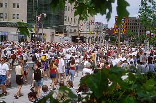
Downtown Ottawa is the central area of Ottawa, Ontario, Canada. Like other downtowns it is the commercial and economic centre of the city. It is sometimes referred to as the Central Business District and contains Ottawa's financial district. It is bordered by the Ottawa River to the north, the Rideau Canal to the east, Gloucester Street to the south and Bronson Avenue to the west. This area and the residential neighbourhood to the south are also known locally as 'Centretown'. The total population of the area is 4,876.

CBC Ottawa Broadcast Centre

The CBC Ottawa Broadcast Centre is an office and studio complex located on Sparks Street in downtown Ottawa, Ontario, Canada. Its primary tenant is the Canadian Broadcasting Corporation, with the building serving as the corporate headquarters of the CBC and hosting the originating studios for the CBC's various English and French language operations in the National Capital Region. The building was opened in 2004, and contains approximately 37,700 square metres of office space.

Canadian Tulip Festival

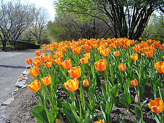
The Canadian Tulip Festival is a tulip festival, held annually in May in Ottawa, Ontario, Canada. The festival claims to be the world's largest tulip festival, displaying over one million tulips, with attendance of over 650,000 visitors annually. Large displays of tulips are planted throughout the city, and the largest display of tulips is found in Commissioners Park on the shores of Dow's Lake, and along the Rideau Canal with 300,000 tulips planted there alone. Millions of tulips set the stage for a celebration of authentic art, cultural, historic, culinary and family tulip experiences at various official venues across the capital.

History of Northwest Territories capital cities

The history of Northwest Territories capital cities begins with the purchase of the Territories by Canada from the Hudson's Bay Company in 1869, and includes a varied and often difficult evolution. Northwest Territories is unique amongst the other provinces and territories of Canada in that it has had seven capital cities in its history. The territory has changed the seat of government for numerous reasons, including civil conflict, development of infrastructure, and a history of significant revisions to its territorial boundaries.

Sir John A. Macdonald Parkway

The Sir John A. Macdonald Parkway, formerly the Ottawa River Parkway, is a four-lane scenic parkway along the Ottawa River in Ottawa, Ontario, Canada. It runs from Carling Avenue near Connaught Avenue, to Booth Street at the Canadian War Museum and National Holocaust Monument. It is maintained by the National Capital Commission. The speed limit is 60 km/h (37 mph). Bicycles are allowed on the road and on a parallel recreational path along the parkway.

Confederation Park Park in Ottawa

Confederation Park(French: Parc de la Confédération) is a public park and National Historic Site of Canada, located in downtown Ottawa, Ontario, Canada. It is bordered on the south by Laurier Avenue and Ottawa City Hall; on the east by the Rideau Canal and National Defence Headquarters; on the north by the Mackenzie King Bridge, the Rideau Centre, and the National Arts Centre; and, to the west, by Elgin Street and the Lord Elgin Hotel.

Centennial Flame monument in Ottawa, Canada

Located on Parliament Hill in Ottawa, Ontario, Canada, the Centennial Flame commemorates Canada's 100th anniversary as a Confederation. The Flame was first lit as the climax of the centennial celebrations of January 1, 1967, in the presence of then Prime Minister Lester B. Pearson. He was joined on the hill by leader of the Opposition and former Prime Minister, John Diefenbaker, and Secretary of State, who was in charge of the Centennial, Judy LaMarsh as well as thousands of onlookers. The Flame is fuelled by natural gas and surrounded by a fountain whose ledge contains the shields of Canada's 13 provinces and territories—Nunavut was originally absent as it was not created until 1999. On December 13, 2017, a Nunavut plaque was unveiled.

The Plaza Bridge in Ottawa, Ontario, Canada is an automotive and pedestrian bridge that crosses the Rideau Canal just south of the Ottawa locks. It joins Wellington Street and Elgin Street in the Downtown core to the west with Rideau Street to the east. The Chateau Laurier abuts the bridge at the east end, while Parliament Hill is just beyond the west end. It is the northernmost bridge over the canal, just north of the Mackenzie King Bridge.

Confederation Square square in Ottawa, Canada

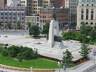
Confederation Square is an urban square in Ottawa, Ontario, Canada, and is considered the second most important ceremonial centre in Canada's capital city, after Parliament Hill. Roughly triangular in area, with Canada's National War Memorial at its centre and the Valiants Memorial at its periphery, the square is bounded by Wellington Street to the north and branches of Elgin Street to the east and west.

The History of Ottawa, capital of Canada, was shaped by events such as the construction of the Rideau Canal, the lumber industry, the choice of Ottawa as the location of Canada's capital, as well as American and European influences and interactions. By 1914, Ottawa's population had surpassed 100,000 and today it is the capital of a G7 country whose metropolitan population exceeds one million.

The Memorial to the Victims of Communism – Canada, a Land of Refuge is a controversial monument that is being built in Ottawa, Ontario, Canada. It was originally to be erected on a site between the Supreme Court of Canada and the National Library of Canada but in December 2015, Canadian Heritage Minister Mélanie Joly suggested that the National Capital Commission instead approve a 500 square metre site half a kilometre to the west, in the Garden of the Provinces and Territories. Under the revised timeline, a national competition was held in 2016 and 2017 to select a new design for the monument. The site was dedicated in a ceremony held on November 2, 2017. Construction is to begin in early 2018 and to be completed by late 2018 or early 2019.

Queen Street (Ottawa) thoroughfare in Ottawa, Ontario

Queen Street is an east-west arterial road located in Downtown Ottawa, Ontario, Canada. The street is two-way with one to two lanes going in each direction. The Confederation Line will run underneath Queen Street when it opens.

References

  1. 1 2 3 4 5 "New Name and Look for Downtown Ottawa Park". Marketwire. Public Works and Government Services Canada. October 6, 2005. Retrieved December 24, 2015.
  2. "Tribute to Liberty missed fundraising target for victims of communism memorial". CBC News. December 23, 2015. Retrieved December 24, 2015.
  3. "Street SmART - A Guide to Art on the Streets of Canada's Capital Region" (PDF). National Capital Commission, Government of Canada. 2010-10-09.
  4. "Sparks, Nicholas". Dictionary of Canadian Biography Online. 2000.
  5. Davidson, Tanya. The ‘Last Good Year’: Revisiting the Centennial Craze . Spacing Ottawa. 2010-03-16.
  6. 1 2 3 Alistair B. Fraser (1998-01-30). The Flags of Canada.