Gare de Denfert-Rochereau

Last updated

Denfert-Rochereau Station. Gare de Denfert-Rochereau - Batiment voyageur.jpg
Denfert-Rochereau Station.

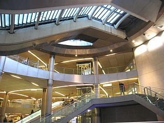
Gare de Denfert-Rochereau is a railway station in Paris. It was one of the first stations of the French railway network, and is still in use as a station of Paris' RER line B.

Paris Capital of France

Paris is the capital and most populous city of France, with an area of 105 square kilometres and an official estimated population of 2,140,526 residents as of 1 January 2019. Since the 17th century, Paris is one of Europe's major centres of finance, diplomacy, commerce, fashion, science, and the arts.

France Republic with mainland in Europe and numerous oversea territories

France, officially the French Republic, is a country whose territory consists of metropolitan France in Western Europe and several overseas regions and territories. The metropolitan area of France extends from the Mediterranean Sea to the English Channel and the North Sea, and from the Rhine to the Atlantic Ocean. It is bordered by Belgium, Luxembourg and Germany to the northeast, Switzerland and Italy to the east, and Andorra and Spain to the south. The overseas territories include French Guiana in South America and several islands in the Atlantic, Pacific and Indian oceans. The country's 18 integral regions span a combined area of 643,801 square kilometres (248,573 sq mi) and a total population of 67.3 million. France, a sovereign state, is a unitary semi-presidential republic with its capital in Paris, the country's largest city and main cultural and commercial centre. Other major urban areas include Lyon, Marseille, Toulouse, Bordeaux, Lille and Nice.

RER B railway line in France

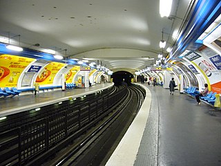
The RER B is one of the five lines in the RER rapid transit system serving Paris, France.

Built from 1842 and opened on 7 June 1846, the station building had a circular shape as it possessed a rail loop. Indeed, the station was the Parisian terminus of a line from Sceaux. This Ligne de Sceaux system, named "Arnoux" (after its inventor), was abandoned at the end of the 19th century as it required the construction of specific engines capable of travelling on very tight curves and broad gauge tracks of 1,750 mm (5 ft 8 78 in). The line was extended to the Gare du Luxembourg in 1895, with the newly created Port-Royal station along the way. The line was operated by the Chemin de Fer de Paris à Orléans until 1937 when the Compagnie du Chemin de Fer Métropolitain de Paris (CMP) (predecessor of the RATP) took over. It became line B of the RER in 1977 on being extended to meet line A at Châtelet – Les Halles.

Sceaux, Hauts-de-Seine Commune in Île-de-France, France

Sceaux is a commune in the southern suburbs of Paris, France. It is located 9.7 km (6.0 mi) from the center of Paris.

Ligne de Sceaux

"La Ligne de Sceaux" was a railway line in France running from Paris to some of its southern suburbs, including Sceaux from which it takes its name. It is now part of the RATP's RER line B, though the name is still used informally.

Gare de Port-Royal railway station in Paris, France

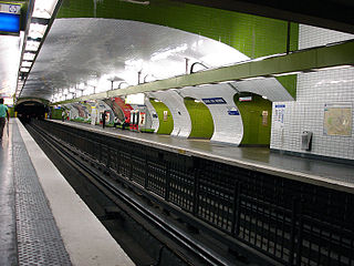
Port-Royal is a railway station on the RER B in Paris, France. It is situated on the border of 5th and 6th arrondissement of Paris, and named after the convent of Port-Royal.

The station building of Denfert-Rochereau station is the oldest railway building still standing in Paris.

Denfert-Rochereau remains a station of line B of the Réseau Express Régional and is an interchange with the métro station of the same name, Station Denfert-Rochereau.

Réseau Express Régional Île-de-France regional express network

The Réseau Express Régional, commonly abbreviated RER, is a hybrid suburban commuter/rapid transit system serving Paris, France and its suburbs. The RER combines the operations and roles of a local city-centre underground rail system and suburbs-to-city-center commuter rail. Inside the city center, the RER functions much like the Métro, but is faster as it has fewer stops. This has made it a model for proposals to improve transit within other cities. The network consists of five lines: A, B, C, D and E. The network has 257 stations and has several connections with the Paris Métro within the city of Paris. The lines are identified by letters to avoid confusion with the Métro lines, which are identified by numbers. The RER is still expanding: Line E, which opened in 1999, is planned for westward extension in two phases by 2020–2022.

Denfert-Rochereau (Paris Métro) Paris Métro station

Denfert-Rochereau is a station on the Paris Métro in France. An adjacent station with the same name is served by RER B.

Related Research Articles

Gare du Nord Railway station in Paris

The Gare du Nord, officially Paris-Nord, is one of the six large terminus stations of the SNCF mainline network for Paris, France. It serves train services toward regions north of Paris, along the Paris–Lille railway. Near Gare de l'Est in the 10th arrondissement, the Gare du Nord offers connections with several urban transport lines, including Paris Métro, RER and buses. By the number of travellers, at around 214 million per year, it is the busiest railway station in Europe, the 24th busiest in the world and the busiest outside Japan.

Saint-Lazare (Paris Métro) Paris Métro station

Saint-Lazare is a station on the Paris Métro serving lines 3, 12, 13 and 14 located on the border of the 8th and 9th arrondissements. It is the second busiest station of the metro system after Gare du Nord with 39 million passengers annually and is the western terminus of line 14.

Gare de lEst railway station in Paris, France

The Gare de l'Est, officially Paris-Est, is one of the six large SNCF termini in Paris. It is in the 10th arrondissement, not far from the Gare du Nord, facing the Boulevard de Strasbourg, part of the north-south axis of Paris created by Baron Haussmann. It is one of the largest and the oldest railway stations in Paris, the western terminus of the Paris–Strasbourg railway and the Paris–Mulhouse railway.

The RER D is one of five RER lines serving Paris, France. It connects Orry-la-Ville and Creil in the north to Melun, Corbeil-Essonnes and Malesherbes in the south, passing through the heart of Paris.

Paris Métro Line 6 rapid transit line in Paris, France

Line 6 is one of the sixteen lines of the Paris Métro rapid transit system. Following a semi-circular route around the southern half of the city above boulevards formed by the former wall of the 'Fermiers généraux' built between 1784 and 1791, it runs between Charles de Gaulle – Étoile in the west and Nation in the east.

The Compagnie des chemins de fer de l'Ouest, often referred to simply as L'Ouest or Ouest, was an early French railway company.

Gare du Nord (Paris Métro) Paris Métro station

Gare du Nord is a Paris Métro station, and serving line 4 and line 5. It is the busiest station in the system, with 48 million entrances a year. It is connected to the SNCF's major station, Gare du Nord, literally, Station of the North, which serves RER lines B and D and Transilien Nord commuter trains as well as interurban trains to northern France, Eurostar trains to London and Thalys trains to Brussels, Amsterdam and Cologne. The station is also connected to the La Chapelle Métro station on line 2 and to the Magenta RER station on RER line E.

Gare dAusterlitz (Paris Métro) Paris Métro station

Gare d'Austerlitz is a station on the Paris Métro, serving line 5 and forming the eastern terminus of line 10 in the 5th and the 13th arrondissements. The Line 5 station hall, "probably the most atypical of the Paris Métro", is open to the exterior though under the roof of the mainline Gare d'Austerlitz and forms part of a sinuous elevated section which has been "considered an exceptional work of urban railway insertion".

Petit-Montrouge administrative quarter in Paris, France

The quartier du Petit-Montrouge is number 55 of the 80 quartiers administratifs in Paris. It lies in the 14th Arrondissement, in the south of the capital. It owes its name to the adjacent commune of Montrouge, of which it formed a part before 1860. It is familiar as the quartier Alésia, from the name of a street that bisects it and from the principal Métro station that serves it, although the quartier Alésia does not exactly overlap the quartier du Petit-Montrouge.

Place Denfert-Rochereau square in Paris, France

Place Denfert-Rochereau, previously known as Place d'Enfer, is a public square located in the 14th arrondissement of Paris, France, in the Montparnasse district, at the intersection of the boulevards Raspail, Arago, and Saint-Jacques, and the avenues René Coty, Général Leclerc, and Denfert-Rochereau, as well as the streets Froidevaux, Victor-Considérant and de Grancey. It is one of the largest and most important squares on the left bank of the Seine.

Paris–Le Havre railway

The Paris–Le Havre railway is an important 228-kilometre long railway line, that connects Paris to the northwestern port city Le Havre via Rouen. Among the first railway lines in France, the section from Paris to Rouen opened on 9 May 1843, followed by the section from Rouen to Le Havre that opened on 22 March 1847.

Jean-Claude-Républicain Arnoux was a French civil engineer known for his invention of the Arnoux system for articulating trains on tight curves. As an entrepreneur he founded and directed the Compagnie de Paris à Orsay, which constructed and operated the line from Paris to Orsay and is now part of the Ligne de Sceaux. It opened on 6 June 1846.

Achères–Grand-Cormier station railway station in Saint-Germain-en-Laye, France

Achères–Grand-Cormier is a French railway station in Saint-Germain-en-Laye, Yvelines département, Île-de-France region.

Émerainville–Pontault-Combault station railway station in Émerainville, France

Émerainville–Pontault-Combault is a French railway station on the Paris-Est–Mulhouse-Ville railway, located in Émerainville, Seine-et-Marne département, Ile-de-France region. It bears the name of Pontault-Combault commune as its territory reaches the south and the west of the building. It serves a district of Marne-la-Vallée.

References

The original content of this article comes from this version of the equivalent French-language Wikipedia article, fr:Gare de Denfert-Rochereau.

Preceding station  RER  Following station
RER.svg Paris RER B icon.svg

Coordinates: 48°49′59″N2°19′59″E / 48.833°N 2.333°E / 48.833; 2.333

Geographic coordinate system Coordinate system

A geographic coordinate system is a coordinate system that enables every location on Earth to be specified by a set of numbers, letters or symbols. The coordinates are often chosen such that one of the numbers represents a vertical position and two or three of the numbers represent a horizontal position; alternatively, a geographic position may be expressed in a combined three-dimensional Cartesian vector. A common choice of coordinates is latitude, longitude and elevation. To specify a location on a plane requires a map projection.