
County Tipperary is a county in Ireland. It is in the province of Munster and the Southern Region. The county is named after the town of Tipperary, and was established in the early 13th century, shortly after the Norman invasion of Ireland. It is Ireland's largest inland county and shares a border with eight counties, more than any other. The population of the county was 167,895 at the 2022 census. The largest towns are Clonmel, Nenagh and Thurles.
Templemore is a town in County Tipperary, Ireland. It is a civil parish in the historical barony of Eliogarty. It is part of the parish of Templemore, Clonmore and Killea in the Roman Catholic Archdiocese of Cashel and Emly.

Shanballymore is a small village in County Cork, Ireland. It neighbours the towns of Doneraile, Kildorrery and Castletownroche, and is off the main route from Mallow to Mitchelstown. Shanballymore is part of the Cork East Dáil constituency.
A townland is a small geographical division of land, historically and currently used in Ireland and in the Western Isles in Scotland, typically covering 100–500 acres (40–202 ha). The townland system is of Gaelic origin, antedating the Norman invasion, and most have names of Irish origin. However, some townland names and boundaries come from Norman manors, plantation divisions, or later creations of the Ordnance Survey. The total number of inhabited townlands in Ireland was 60,679 in 1911. The total number recognised by the Irish Place Names database as of 2014 was 61,098, including uninhabited townlands, mainly small islands.

Newport is a town in County Tipperary in Ireland. It is in the barony of Owney and Arra. At the 2022 census the population was 2,183.
O'Dea, is an Irish surname derived from Deághaidh, the name of a tenth-century clan chieftain. According to historian C. Thomas Cairney, the O'Deas were one of the chiefly families of the Dal gCais or Dalcassians who were a tribe of the Erainn who were the second wave of Celts to settle in Ireland between about 500 and 100 BC.

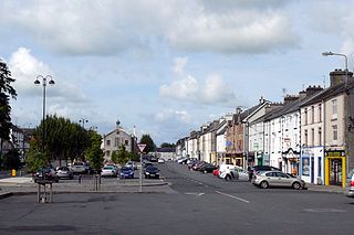
New Inn is a village in County Tipperary in Ireland. It is also in the barony of Middle Third, and part of the parish of New Inn and Knockgraffon in the Roman Catholic Archdiocese of Cashel and Emly.
Kilmoyler is a townland in the civil parish of Killardry in the barony of Clanwilliam, County Tipperary in Ireland. The townland is in the parish of 'Bansha and Kilmoyler' in the Roman Catholic Archdiocese of Cashel and Emly.

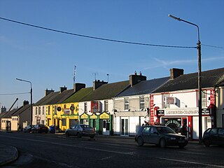
Bansha is a village in County Tipperary in Ireland. The village is part of the parish of "Bansha and Kilmoyler" in the Roman Catholic Archdiocese of Cashel and Emly. It is in the historical barony of Clanwilliam. Bansha is co-extensive with the pre-Reformation parish of Templeneiry of which the townland name of Templenahurney is thought to be a corruption. While the village is the focal point of the area, there is also an outlying hamlet in the parish, located at Rossadrehid where a rural creamery once serviced the dairy industry.

Dundrum is a village in County Tipperary, Ireland. In the 2016 census, the population was 165. It is in the barony of Kilnamanagh Lower.
Littleton is a village in County Tipperary, Ireland. It is within the townlands of Ballybeg and Ballydavid, about 18 km (11 mi) northeast of Cashel and to the southeast of Thurles. By-passed by the M8 in December 2008, Littleton lies at a crossroads on the R639 road. Its population was 394 at the 2016 census. It is in the barony of Eliogarty.

The Devil's Bit or Devil's Bit Mountain is a large hill in County Tipperary, Ireland, which rises to 480 metres (1,570 ft). It lies north-west of the town of Templemore. The mountain is usually climbed through the townland of Barnane. There is a car park at the base.
Golden is a village in County Tipperary in Ireland. The village is situated on the River Suir. It is located between the towns of Cashel and Tipperary on the N74 road. In older times the village was known as Goldenbridge. It is also a parish in the Roman Catholic Archdiocese of Cashel and Emly, and is in the historical barony of Clanwilliam.
Boytonrath is a townland in the barony of Middle Third, Ireland. It is a rural townland with, as of the 2011 census, a population of 88 people. The nearest town is New Inn. Formerly a parish in its own right, Boytonrath is now part of the parish of New Inn & Knockgraffon in the Roman Catholic Archdiocese of Cashel and Emly.
Gortnahoe, also known as Gortnahoo, is a village in County Tipperary, Ireland. It is located on the R689 regional road 6 km (3.7 mi) south of Urlingford, County Kilkenny. It is 3 km (1.9 mi) southeast of the N8 Dublin - Cork road. Gortnahoe, pronounced "Gurt/na/hoo" by the locals, is part of the parish of Gortnahoe–Glengoole.
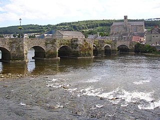
Carrickbeg is a village in County Tipperary, Ireland. Located on the border with County Waterford, it comprises that part of the town of Carrick-on-Suir lying south of the River Suir. The area is in County Tipperary, but some residents have an affinity for County Waterford, as well as it previously having been a part of that county.
Rossmore is a small village and townland in County Tipperary in Ireland. It is in the civil parish of Clonoulty, barony of Kilnamanagh Lower. It is located in the electoral division (ED) of Clonoulty West. It is also half of the Clonoulty and Rossmore parish in the Roman Catholic Archdiocese of Cashel and Emly.
Ikerrin is a barony in County Tipperary, Ireland. This geographical unit of land is one of 12 baronies in County Tipperary. Its chief town is Roscrea. The barony lies between Eliogarty to the south and Ormond Upper to the west. As a "peninsula", it is surrounded on three sides by counties Offaly and Laois. The territory is currently administered by Tipperary County Council.

Eliogarty is a barony in County Tipperary, Ireland. This geographical unit of land is one of 12 baronies in County Tipperary. Its chief town is Thurles. The barony lies between Ikerrin to the north, Kilnamanagh Upper to the west, Middle Third to the south and County Kilkenny to the east. It is currently administered by Tipperary County Council.
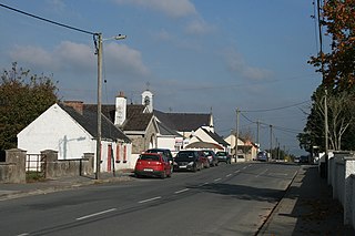
Ballysheehan is a village in the southern part of County Tipperary, Ireland. It is also a civil parish in the barony of Middle Third, within the Munster province.
