Gartz (Amt)

Last updated

Gartz (Oder) is an Amt ("municipal federation") in the district of Uckermark, in Brandenburg, Germany. Its seat is in Gartz.

The Uckermark is a historical region in northeastern Germany, currently straddles the Uckermark District of Brandenburg and the Vorpommern-Greifswald District of Mecklenburg-Vorpommern. Its traditional capital is Prenzlau.

Brandenburg State in Germany

Brandenburg is a state of Germany.

Germany Federal parliamentary republic in central-western Europe

Germany, officially the Federal Republic of Germany is a country in Central and Western Europe, lying between the Baltic and North Seas to the north and the Alps, Lake Constance and the High Rhine to the south. It borders Denmark to the north, Poland and the Czech Republic to the east, Austria and Switzerland to the south, France to the southwest, and Luxembourg, Belgium and the Netherlands to the west.

The Amt Gartz (Oder) consists of the following municipalities:

  1. Casekow
  2. Gartz
  3. Hohenselchow-Groß Pinnow
  4. Mescherin
  5. Tantow

Demography

About 2000 inhabitants are Polish. [1]

Nazi Germany The German state from 1933 to 1945, under the dictatorship of Adolf Hitler

Nazi Germany is the common English name for Germany between 1933 and 1945, when Adolf Hitler and his Nazi Party (NSDAP) controlled the country through a dictatorship. Under Hitler's rule, Germany was transformed into a totalitarian state where nearly all aspects of life were controlled by the government. The official name of the state was Deutsches Reich until 1943 and Großdeutsches Reich from 1943 to 1945. Nazi Germany is also known as the Third Reich, meaning "Third Realm" or "Third Empire", the first two being the Holy Roman Empire (800–1806) and the German Empire (1871–1918). The Nazi regime ended after the Allies defeated Germany in May 1945, ending World War II in Europe.

East Germany Former communist state, 1949-1990

East Germany, officially the German Democratic Republic, was a state that existed from 1949 to 1990, when the eastern portion of Germany was part of the Eastern Bloc during the Cold War. Commonly described as a communist state in English usage, it described itself as a socialist "workers' and peasants' state." It consisted of territory that was administered and occupied by Soviet forces at the end of World War II — the Soviet occupation zone of the Potsdam Agreement, bounded on the east by the Oder–Neisse line. The Soviet zone surrounded West Berlin but did not include it; as a result, West Berlin remained outside the jurisdiction of the GDR.

Census in Germany Wikimedia list article

A national census in Germany was held every five years from 1875 to 1910. After the World Wars, only a few full population censuses have been held, the last in 1987. The most recent census, though not a national census, was the 2011 European Union census.

Amt Gartz (Oder): Population development
within the current boundaries (2013) [2]
YearPop.±% p.a.
1875 13,932    
1890 13,233−0.34%
1910 12,328−0.35%
1925 12,778+0.24%
1933 12,771−0.01%
1939 13,079+0.40%
1946 16,505+3.38%
1950 16,704+0.30%
1964 12,560−2.02%
1971 11,809−0.88%
1981 9,231−2.43%
1985 8,796−1.20%
1989 8,453−0.99%
1990 8,371−0.97%
YearPop.±% p.a.
1991 8,168−2.43%
1992 8,380+2.60%
1993 8,214−1.98%
1994 8,043−2.08%
1995 8,074+0.39%
1996 8,042−0.40%
1997 8,031−0.14%
1998 7,992−0.49%
1999 7,980−0.15%
2000 7,895−1.07%
2001 7,781−1.44%
2002 7,707−0.95%
2003 7,604−1.34%
2004 7,511−1.22%
YearPop.±% p.a.
2005 7,343−2.24%
2006 7,185−2.15%
2007 7,125−0.84%
2008 7,098−0.38%
2009 7,063−0.49%
2010 7,057−0.08%
2011 6,745−4.42%
2012 6,714−0.46%
2013 6,708−0.09%
2014 6,736+0.42%
2015 6,737+0.01%
2016 6,776+0.58%
2017 6,846+1.03%
2018 6,872+0.38%

Related Research Articles

Oberhavel is a Kreis (district) in the northern part of Brandenburg, Germany. Its neighbouring districts are : Mecklenburg-Strelitz in Mecklenburg-Western Pomerania, the districts of Uckermark and Barnim, the Bundesland of Berlin, and the districts of Havelland and Ostprignitz-Ruppin.

Uckermark is a Kreis (district) in the northeastern part of Brandenburg, Germany. Neighboring districts are Barnim and Oberhavel, the districts Mecklenburgische Seenplatte and Vorpommern-Greifswald in Mecklenburg-Vorpommern, and to the east Poland. It is the largest district of Germany areawise. The district is named after the historical region of Uckermark.

Barnim is a district in Brandenburg, Germany. It is bounded by Poland, the district of Märkisch-Oderland, the city state of Berlin and the districts of Oberhavel and Uckermark.

Oder-Spree is a Kreis (district) in the eastern part of Brandenburg, Germany. Neighboring are the district Märkisch-Oderland, the district-free city Frankfurt (Oder), Poland, the districts Spree-Neiße and Dahme-Spreewald, and the Bundesland Berlin.

Nordwestuckermark Place in Brandenburg, Germany

Nordwestuckermark is a municipality in the Uckermark district, in Brandenburg, Germany.

Uckerland Place in Brandenburg, Germany

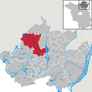
Uckerland is a municipality in the Uckermark district, in Brandenburg, Germany.

Barnim-Oderbruch collective municipality in Brandenburg state, Germany

Barnim-Oderbruch is an Amt in the district of Märkisch-Oderland, in Brandenburg, Germany. Its seat is in Wriezen, itself not part of the Amt.

Seelow-Land is an Amt in the district of Märkisch-Oderland, in Brandenburg, Germany. Its seat is in Seelow, itself not part of the Amt.

Lebus is an Amt in the district of Märkisch-Oderland, in Brandenburg, Germany. Its seat is in Lebus.

Neuzelle is an Amt in the district of Oder-Spree, in Brandenburg, Germany. Its seat is in Neuzelle.

Brieskow-Finkenheerd is an Amt in the district of Oder-Spree, in Brandenburg, Germany. Its seat is in Brieskow-Finkenheerd.

Odervorland is an Amt in the district of Oder-Spree, in Brandenburg, Germany. Its seat is in Briesen.

Scharmützelsee is an Amt in the district of Oder-Spree, in Brandenburg, Germany. Its seat is in Bad Saarow.

Schlaubetal (Amt) collective municipality in Brandenburg state, Germany

Schlaubetal is an Amt in the district of Oder-Spree, in Brandenburg, Germany. Its seat is in Müllrose.

Spreenhagen is an Amt in the district of Oder-Spree, in Brandenburg, Germany. Its seat is in Spreenhagen.

Meyenburg is an Amt in the district of Prignitz, in Brandenburg, Germany. Its seat is in Meyenburg.

Gramzow is an Amt in the district of Uckermark, in Brandenburg, Germany. Its seat is in Gramzow.

Brüssow (Uckermark) is an Amt in the district of Uckermark, in Brandenburg, Germany. Its seat is in Brüssow.

Gerswalde is an Amt in the district of Uckermark, in Brandenburg, Germany. Its seat is in Gerswalde.

Oder-Welse is an Amt in the district of Uckermark, in Brandenburg, Germany. Its seat is in Pinnow.

References

Coordinates: 53°16′59″N14°19′59″E / 53.283°N 14.333°E / 53.283; 14.333

Geographic coordinate system Coordinate system

A geographic coordinate system is a coordinate system that enables every location on Earth to be specified by a set of numbers, letters or symbols. The coordinates are often chosen such that one of the numbers represents a vertical position and two or three of the numbers represent a horizontal position; alternatively, a geographic position may be expressed in a combined three-dimensional Cartesian vector. A common choice of coordinates is latitude, longitude and elevation. To specify a location on a plane requires a map projection.