Lenzen-Elbtalaue

Last updated

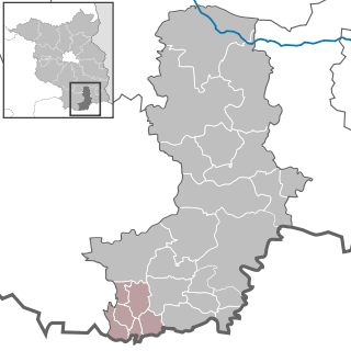
Lenzen-Elbtalaue is an Amt ("municipal federation") in the district of Prignitz, in Brandenburg, Germany. Its seat is in Lenzen (Elbe).

Amt is a type of administrative division governing a group of municipalities, today only in Germany, but formerly also common in other countries of Northern Europe. Its size and functions differ by country and the term is roughly equivalent to a US township or county or English shire district.

Prignitz District in Brandenburg, Germany

Prignitz is a Kreis (district) in the northwestern part of Brandenburg, Germany. Neighboring are the district Ludwigslust-Parchim in Mecklenburg-Western Pomerania, the district Ostprignitz-Ruppin in Brandenburg, the district Stendal in Saxony-Anhalt and the district Lüchow-Dannenberg in Lower Saxony.

Brandenburg State in Germany

Brandenburg is a state of Germany.

The Amt Lenzen-Elbtalaue consists of the following municipalities:

  1. Cumlosen
  2. Lanz
  3. Lenzen (Elbe)
  4. Lenzerwische

Demography

Nazi Germany The German state from 1933 to 1945, under the dictatorship of Adolf Hitler

Nazi Germany is the common English name for Germany between 1933 and 1945, when Adolf Hitler and his Nazi Party (NSDAP) controlled the country through a dictatorship. Under Hitler's rule, Germany was transformed into a totalitarian state that controlled nearly all aspects of life via the Gleichschaltung legal process. The official name of the state was Deutsches Reich until 1943 and Großdeutsches Reich from 1943 to 1945. Nazi Germany is also known as the Third Reich, meaning "Third Realm" or "Third Empire", the first two being the Holy Roman Empire (800–1806) and the German Empire (1871–1918). The Nazi regime ended after the Allies defeated Germany in May 1945, ending World War II in Europe.

East Germany Former communist country, 1949-1990

East Germany, officially the German Democratic Republic, was a country that existed from 1949 to 1990, when the eastern portion of Germany was part of the Eastern Bloc during the Cold War. It described itself as a socialist "workers' and peasants' state", and the territory was administered and occupied by Soviet forces at the end of World War II — the Soviet Occupation Zone of the Potsdam Agreement, bounded on the east by the Oder–Neisse line. The Soviet zone surrounded West Berlin but did not include it; as a result, West Berlin remained outside the jurisdiction of the GDR.

Census in Germany Wikimedia list article

A national census in Germany was held every five years from 1875 to 1910. After the World Wars, only a few full population censuses have been held, the last in 1987. The most recent census, though not a national census, was the 2011 European Union census.

Amt Lenzen-Elbtalaue: Population development
within the current boundaries (2017) [1]
YearPop.±% p.a.
1875 9,541    
1890 8,932−0.44%
1910 8,295−0.37%
1925 8,443+0.12%
1933 8,166−0.42%
1939 8,003−0.34%
1946 10,524+3.99%
1950 10,497−0.06%
1964 7,630−2.25%
1971 7,310−0.61%
1981 6,115−1.77%
1985 5,959−0.64%
1989 5,843−0.49%
1990 5,761−1.40%
YearPop.±% p.a.
1991 5,550−3.66%
1992 5,538−0.22%
1993 5,480−1.05%
1994 5,447−0.60%
1995 5,390−1.05%
1996 5,355−0.65%
1997 5,342−0.24%
1998 5,304−0.71%
1999 5,302−0.04%
2000 5,222−1.51%
2001 5,132−1.72%
2002 5,073−1.15%
2003 5,033−0.79%
2004 4,997−0.72%
YearPop.±% p.a.
2005 4,947−1.00%
2006 4,838−2.20%
2007 4,763−1.55%
2008 4,675−1.85%
2009 4,572−2.20%
2010 4,507−1.42%
2011 4,398−2.42%
2012 4,343−1.25%
2013 4,260−1.91%
2014 4,205−1.29%
2015 4,164−0.98%
2016 4,075−2.14%
2017 4,040−0.86%

Related Research Articles

Perleberg Place in Brandenburg, Germany

Perleberg is the capital of the district of Prignitz, located in the northwest of the German state of Brandenburg. The town received city rights in 1239 and today has about 12,000 inhabitants. Located in a mostly agricultural area, the town has a long history of troops being stationed here and as an administrative center for local government.

Elsterland is an Amt in the district of Elbe-Elster, in Brandenburg, Germany. Its seat is in Schönborn.

Kleine Elster (Niederlausitz)

Kleine Elster (Niederlausitz) is an Amt in the district of Elbe-Elster, in Brandenburg, Germany. Its seat is in Massen-Niederlausitz.

Schlieben is an Amt in the district of Elbe-Elster, in Brandenburg, Germany. Its seat is in Schlieben.

Lebus is an Amt in the district of Märkisch-Oderland, in Brandenburg, Germany. Its seat is in Lebus.

Ortrand (Amt) Collective municipality in Brandenburg state, Germany

Ortrand is an Amt in the district of Oberspreewald-Lausitz, in Brandenburg, Germany. Its seat is in Ortrand.

Odervorland is an Amt in the district of Oder-Spree, in Brandenburg, Germany. Its seat is in Briesen.

Temnitz is an Amt in the district of Ostprignitz-Ruppin, in Brandenburg, Germany. Its seat is in Walsleben.

Beetzsee is an Amt in the district of Potsdam-Mittelmark, in Brandenburg, Germany. Its seat is in Beetzsee.

Wusterwitz is an Amt in the district of Potsdam-Mittelmark, in Brandenburg, Germany. Its seat is in Wusterwitz.

Ziesar is an Amt in the district of Potsdam-Mittelmark, in Brandenburg, Germany. Its seat is in Ziesar.

Meyenburg is an Amt in the district of Prignitz, in Brandenburg, Germany. Its seat is in Meyenburg.

Putlitz-Berge

Putlitz-Berge is an Amt in the district of Prignitz, in Brandenburg, Germany. Its seat is in Putlitz.

Döbern-Land is an Amt in the district of Spree-Neiße, in Brandenburg, Germany. Its seat is in Döbern.

Gramzow is an Amt in the district of Uckermark, in Brandenburg, Germany. Its seat is in Gramzow.

Brüssow (Uckermark) is an Amt in the district of Uckermark, in Brandenburg, Germany. Its seat is in Brüssow.

Gartz (Oder) is an Amt in the district of Uckermark, in Brandenburg, Germany. Its seat is in Gartz.

Gerswalde is an Amt in the district of Uckermark, in Brandenburg, Germany. Its seat is in Gerswalde.

Oder-Welse is an Amt in the district of Uckermark, in Brandenburg, Germany. Its seat is in Pinnow.

References

  1. Detailed data sources are to be found in the Wikimedia Commons.Population Projection Brandenburg at Wikimedia Commons

Coordinates: 53°04′01″N11°28′01″E / 53.067°N 11.467°E / 53.067; 11.467

Geographic coordinate system Coordinate system

A geographic coordinate system is a coordinate system that enables every location on Earth to be specified by a set of numbers, letters or symbols. The coordinates are often chosen such that one of the numbers represents a vertical position and two or three of the numbers represent a horizontal position; alternatively, a geographic position may be expressed in a combined three-dimensional Cartesian vector. A common choice of coordinates is latitude, longitude and elevation. To specify a location on a plane requires a map projection.