The Queen Alexandra Range is a major mountain range about 100 nautical miles long, bordering the entire western side of Beardmore Glacier from the Polar Plateau to the Ross Ice Shelf. The range is in the Transantarctic Mountains System, and is located in the Ross Dependency region of Antarctica.
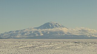
Mount Discovery is a conspicuous, isolated volcanic cone, 2,680 metres (8,790 ft) high, lying at the head of McMurdo Sound and east of Koettlitz Glacier, overlooking the northwest portion of the Ross Ice Shelf. It forms the center of a three-armed mass of which Brown Peninsula is one extension to the north; Minna Bluff is a second to the east; the third is Mount Morning to the west. Mount Discovery was discovered by the British National Antarctic Expedition (1901–04) and named for their expedition ship Discovery.

Koettlitz Glacier is a large Antarctic glacier lying west of Mount Morning and Mount Discovery in the Royal Society Range, flowing from the vicinity of Mount Cocks northeastward between Brown Peninsula and the mainland into the ice shelf of McMurdo Sound.
Alph River is a small river, flowing in summertime, on the northern side of Koettlitz Glacier, Scott Coast, Antarctica. It rises from Koettlitz ice at the upper end of Pyramid Trough and from south to north includes Pyramid Ponds, Trough Lake, Walcott Lake, Howchin Lake, and Alph Lake. The Alph ends in a subglacial stream beneath Koettlitz Glacier to McMurdo Sound.

Miers Valley is a valley just south of Marshall Valley and west of Koettlitz Glacier, on the coast of Victoria Land, Antarctica. The valley is ice-free except for Miers Glacier in its upper (western) part and Lake Miers near its center. It was mapped and named by Robert Falcon Scott's British Antarctic Expedition, 1910–13. The name is possibly after Edward J. Miers, a marine biologist from the British Museum who examined crustacea from the Erebus and Terror expeditions.
Mount Schwerdtfeger is a peak, 2,950 metres (9,680 ft) high on the ridge at the head of Renegar Glacier, 1.75 nautical miles south of Mount Kempe in the Royal Society Range, Victoria Land, Antarctica.

Mount Lister is a massive mountain, 4,025 metres (13,205 ft) high, forming the highest point in the Royal Society Range of Victoria Land, Antarctica. It was discovered by the British National Antarctic Expedition (1901–1904) which named it for Lord Joseph Lister, President of the Royal Society, 1895–1900.
The Newall Glacier is a glacier in the east part of the Asgard Range of Victoria Land, It flows east between Mount Newall and Mount Weyant into the Wilson Piedmont Glacier. The Newall Glacier was mapped by the N.Z. Northern Survey Party of the CTAE, 1956-58, who named it after nearby Mount Newall.
Ward Valley is an ice-free valley that lies between Porter Hills and Xanadu Hills and east of the snout of Ward Glacier in the Denton Hills, Scott Coast, Antarctica. Named by Advisory Committee on Antarctic Names in association with Ward Glacier and Ward Lake.
Campbell Glacier is a glacier, about 60 nautical miles long, originating near the south end of Mesa Range and draining southeast between the Deep Freeze Range and Mount Melbourne to discharge into north Terra Nova Bay in Victoria Land, Antarctica.
The Denton Hills are a group of rugged foothills, 24 nautical miles long southwest–northeast and 9 nautical miles wide, to the east of the Royal Society Range on the Scott Coast, Victoria Land, Antarctica.
Péwé Peak is a bedrock peak, 860 metres (2,820 ft) high, composed of granite and topped with a dolerite sill. The peak is immediately south of Joyce Glacier and is surrounded by glacial ice except on the south side. It was named by the Advisory Committee on Antarctic Names for Troy L. Péwé, a glacial geologist with U.S. Navy Operation Deep Freeze, 1957–58, who personally explored this peak as well as adjacent portions of Victoria Land.
Marshall Valley is a small valley in Antarctica, ice free except for Rivard Glacier at its western head. It is 12.5 kilometres (7.8 mi) long, and 3 kilometres (1.9 mi) wide, and lies between Garwood Valley and Miers Valley on the coast of Victoria Land. It is one of the McMurdo Dry Valleys. The valley is open to the Ross Sea to the east.
Hobbs Ridge is a prominent arc-shaped ridge which circumscribes Hobbs Glacier to the north and northwest and forms the divide with the lower part of Blue Glacier, on the Scott Coast of Victoria Land, Antarctica. It was named in association with Hobbs Glacier. It forms the northernmost part of the Denton Hills.
The MacDonald Hills are a compact group of exposed rock hills in the Asgard Range, east of Commonwealth Glacier on the north side of lower Taylor Valley, Victoria Land, Antarctica. The hills were named by the Advisory Committee on Antarctic Names (US-ACAN) (1997) after William R. MacDonald (1925–77), Chief of the Branch of International Activities, U.S. Geological Survey, and a member of the US-ACAN, part of the U.S. Board on Geographic Names, 1976–77.
The Horowitz Ridge is a rock ridge between David Valley and King Valley in the Asgard Range of Victoria Land, Antarctica.
Roa Ridge is a bow-shaped ridge, 5 mi (8.0 km) long in the Asgard Range of Victoria Land, Antarctica. For much of its extent, it separates Matterhorn Glacier and Lacroix Glacier. Named by New Zealand Geographic Board (NZGB) in 1998. Roa is a Maori word meaning “long” ridge.
Blue Glacier is a large glacier which flows into Bowers Piedmont Glacier about 10 nautical miles south of New Harbour, in Victoria Land, Antarctica. It was discovered by the British National Antarctic Expedition (BrNAE) under Robert Falcon Scott, 1901–04, who gave it this name because of its clear blue ice at the time of discovery.
Hidden Valley is the ice-free valley next south of Miers Valley through which an alpine glacier formerly moved to coalesce with Koettlitz Glacier. The mouth of the valley is completely blocked by the Koettlitz moraine, the only one of the numerous valleys tributary to the Koettlitz isolated in this fashion. The main valley is hidden not only from the coast but from most of the surrounding ridges. The valley was traversed during December and January by the New Zealand Victoria University of Wellington Antarctic Expedition (VUWAE) 1960-61 who applied the name.
Table Mountain is a large flat mountain rising to over 2,000 metres (6,600 ft) immediately south of the junction of the Emmanuel Glacier and Ferrar Glacier in Victoria Land. Discovered and given this descriptive name by the BrNAE (1901–04) under Scott.


