Sources disagree as to the current population of Eritrea, with some proposing numbers as low as 3.6 million and others as high as 6.7 million. Eritrea has never conducted an official government census.
The Politics of Eritrea and the Government of Eritrea takes place in a framework of a single-party presidential republican totalitarian dictatorship. The President officially serves as both head of state and head of government. The People's Front for Democracy and Justice is the only political party legally permitted to exist in Eritrea. The popularly elected National Assembly of 150 seats, formed in 1993 shortly after independence from Ethiopia, elected the current president, Isaias Afwerki. There have been no general elections since its official independence in 1993. A new constitution was drafted in 1993 and ratified in 1997, but has not been implemented. Since the National Assembly last met in January 2002, President Isaias Afwerki has exercised the powers of both the executive and legislative branches of government.

The regions of Eritrea are the primary geographical divisions through which Eritrea is administered. Six in total, they include the Central, Anseba, Gash-Barka, Southern, Northern Red Sea and Southern Red Sea regions.
Badme is a town in Gash-Barka region of Eritrea. Control of the town was at the centre of the Eritrean–Ethiopian border conflict, which lasted from the beginning of the Eritrean–Ethiopian War, in 1998, to the signing of a joint statement at the Eritrea–Ethiopia summit in 2018, twenty years later.

The Mareb River, or Gash River is a river flowing out of central Eritrea. Its chief importance is defining part of the boundary between Eritrea and Ethiopia, between the point where the Mai Ambassa enters the river at 14°53.6′N37°54.8′E to the confluence of the Balasa with the Mareb at 14°38′N39°1.3′E.

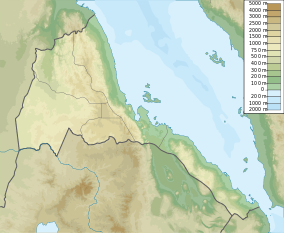
Gash-Barka is an administrative region of Eritrea. It is situated in the south-west of the country, bordering the Anseba region to the north, and the Maekel (Central) and Debub (Southern) regions to the east; the country of Sudan lies to the west and Ethiopia to the south.
Teseney, also spelled Tessenei or Tesseney, is a market town in western Eritrea. It lies south-east of Kassala in Sudan, on the Gash River. The city was much fought over in the Eritrean War of Independence during which much of it was destroyed. After the war, Tessenei has become a governmental administrative center with customs and agricultural offices and a military base.

The Kunama are an ethnic group native to Eritrea. They are one of the smallest ethnic communities in Eritrea, constituting only 4% of the population. Most of the estimated 260,000 Kunama live in the remote and isolated area between the Gash and Setit rivers near the border with Ethiopia. The Kunama people have ancient ancestry in the land of Eritrea. In the 2007 Ethiopian census, however, the number of Kunama in Tigray has dropped to 2,976 as the remaining 2,000 or so members of this ethnic group have migrated into the other regions of Ethiopia.

Barentu is a town in north-western Eritrea, lying south of Agordat, and is the capital of Gash-Barka Region. The town is integrated with different types of tribes: Kunama, Nara, Tigre and Tigrinya being the most dominant.

The Nara (Nera) or Barea (Barya) language is spoken by the Nara people in an area just to the north of Barentu in the Gash-Barka Region of western Eritrea. The language is often confused with Kunama, which is at best only distantly related.

The Kunama language has been included in the proposed Nilo-Saharan language family, though it is distantly related to the other languages, if at all. Kunama is spoken by the Kunama people of the Gash-Barka Region in western Eritrea and just across the Ethiopian border. The language has several dialects including: Barka, Marda, Aimara, Odasa, Tika, Lakatakura, Sokodasa, Takazze-Setit and Tigray. Ilit and Bitama are not mutually intelligible and so may be considered distinct languages.
The provinces of Eritrea existed since pre-Axumite times and became administrative provinces from Eritrea's incorporation as a colony of Italy until the conversion of the provinces into administrative regions. Many of the provinces had their own local laws since the 13th century.

Eritreans are the native inhabitants of Eritrea, as well as the global diaspora of Eritrea. Eritreans constitute several component ethnic groups, some of which are related to ethnic groups that make up the Ethiopian people in neighboring Ethiopia and people groups in other parts of the Horn of Africa. Nine of these component ethnic groups are officially recognized by the Government of Eritrea.
Om Hajar Subregion is a subregion in the western Gash-Barka region of Eritrea. Its capital lies at Om Hajar. The area has a patented history with the Italians and the struggle between the Eritreans and Ethiopians.
Adendema is a village in western Eritrea. It is located 5.8 miles south-west of the district capital of Haykota in Haykota District in the Gash-Barka region. It lies on the north-east boundary of the Gash-Setit wildlife reserve.
Arcugi is a village in western Eritrea. It is located in Omhajer District in the Gash-Barka region. It lies inside the Gash-Setit wildlife reserve 6 kilometres south-west of Giamal Biscia.
Giamal Biscia is a village in western Eritrea. It is located in the Omhajer Subregion of the Gash-Barka region. It lies inside the Gash-Setit wildlife reserve 6 kilometres north-east of Arcugi.
Eritrea, officially the State of Eritrea,, is a country in the Horn of Africa region of Eastern Africa, with its capital and largest city at Asmara. It is bordered by Ethiopia in the south, Sudan in the west, and Djibouti in the southeast. The northeastern and eastern parts of Eritrea have an extensive coastline along the Red Sea. The nation has a total area of approximately 117,600 km2 (45,406 sq mi), and includes the Dahlak Archipelago and several of the Hanish Islands.
Kafta Sheraro National Park is a national park in the Tigray. Kafta Sheraro National Park is the only national park in Tigrai and one of the few highly bio-diversified parks in East Africa. It was established more than 50 years ago by Raesi Mengesha Seyoum, the then ruler of Tigray province as Shire Wildlife. But it was only in 2007 that it got formal recognition as a national park. It was governed by the Ethiopia Wildlife Conservation Authority.

Heuglin's gazelle, also known as the Eritrean gazelle, is a species of gazelle found east of the Nile River in Eritrea, Ethiopia and Sudan. It was considered a subspecies of the red-fronted gazelle or conspecific with Thomson's gazelle and Mongalla gazelle by some authors in the past. This small gazelle stands nearly 67 cm (26 in) at the shoulder and weighs between 15 and 35 kg. The coat is dark reddish brown with a dark reddish stripe on the flanks, except for the underparts and the rump which are white. Horns, present in both sexes, measure 15 to 35 cm in length.