
The Baltic Sea is an arm of the Atlantic Ocean, enclosed by Denmark, Estonia, Finland, Germany, Latvia, Lithuania, Poland, Russia, Sweden and the North and Central European Plain.

The Kattegat is a 30,000 km2 (12,000 sq mi) sea area bounded by the Jutlandic peninsula in the west, the Danish Straits islands of Denmark and the Baltic Sea to the south and the provinces of Västergötland, Skåne, Halland and Bohuslän in Sweden in the east. The Baltic Sea drains into the Kattegat through the Danish Straits. The sea area is a continuation of the Skagerrak and may be seen as a bay of the North Sea, but in traditional Scandinavian usage, this is not the case.
The Gulf of Bothnia is the northernmost arm of the Baltic Sea. It is situated between Finland's west coast (Ostrobothnia) and Sweden's east coast. In the south of the gulf lie the Åland Islands, between the Sea of Åland and the Archipelago Sea.

The Skagerrak is a strait running between the Jutland peninsula of Denmark, the southeast coast of Norway and the west coast of Sweden, connecting the North Sea and the Kattegat sea area through the Danish Straits to the Baltic Sea.

Hiddensee is a car-free island in the Baltic Sea, located west of Germany's largest island, Rügen, on the German coast.
Ostrów Island is an island on the Baltic Sea, located in the delta of Vistula river. The island composes a portion of the territory of the city of Gdańsk, Poland. More specifically, it is part of the quarter known as Mlyniska.
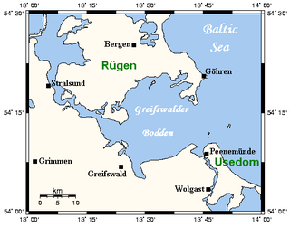
The Bay of Greifswald or Greifswald Bodden is a basin in the southwestern Baltic Sea, off the shores of Germany in the state of Mecklenburg-Vorpommern. With an area of 514 km², it is the largest Bodden of the German Baltic coast.

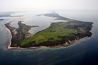
Hel(listen) is a town in Puck County, Pomeranian Voivodeship, Poland, located on the tip of the Hel Peninsula, some 33 kilometres from the Polish mainland.

Zingst is the easternmost portion of the three-part Fischland-Darß-Zingst Peninsula, located in Mecklenburg-Vorpommern, Germany, between the cities of Rostock and Stralsund on the southern shore of the Baltic Sea.
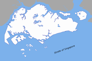
The Singapore Strait is a 114-kilometer-long (71 mi), 16-kilometer-wide (9.9 mi) strait between the Strait of Malacca in the west and the South China Sea in the east. Singapore is on the north of the channel, and the Riau Islands are on the south. The Indonesia-Singapore border lies along the length of the strait.

The island of Ummanz lies in the Baltic Sea, off the west coast of the island of Rügen, and belongs, like the latter, to the county of Vorpommern-Rügen in the German state of Mecklenburg-Western Pomerania.
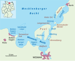
The Bay of Wismar or more commonly Wismar Bay or Wismarbucht is a well sheltered multi-sectioned bay in the southwestern Baltic Sea, in Mecklenburg-Vorpommern, Germany, and is considered the south-central part of the much larger arm of the Baltic known as the Mecklenburg Bay —a long fingerlike gulf oriented to the west-southwest (WSW) from the (central) Baltic proper. Wismar bay is considered one of the finest natural harbors on the Baltic, and served as the destination for much seaborne shipping until circa the 1910s when its minimum depths of 5 meters (16 ft) became too shallow for larger more modern ships. Today, because of the shallow sheltered waters the bay is the subject of much research via underwater archeology
Vorpommern-Rügen is a district in the north of Mecklenburg-Vorpommern, Germany. It is bounded by the Baltic Sea and the districts Vorpommern-Greifswald, Mecklenburgische Seenplatte and Rostock. The district seat is the Hanseatic city of Stralsund.

The Vistula Lagoon is a brackish water lagoon on the Baltic Sea roughly 56 miles (90 km) long, 6 to 15 miles wide, and up to 17 feet (5 m) deep, separated from the Gdańsk Bay by the Vistula Spit. The modern German name, Frisches Haff, is derived from an earlier form, Friesisches Haff.

The Großer Jasmunder Bodden belongs to the Northern Rügener Boddens and is a water body on the southern edge of the Baltic Sea in the German state of Mecklenburg-Vorpommern. It is a bodden, a type of lagoon that occurs in northern Europe especially on the coast of Pomerania. It lies within the island of Rügen, is around 14 kilometres long, an average of six kilometres wide and is up to nine metres deep with an average depth of 5.3m. The Großer Jasmunder Bodden has an area of 58.6 square kilometres; if the Breetzer Bodden, Breeger Bodden, Lebbiner Bodden, Neuendorfer Wiek and Tetzitzer See are included the total area of water comes to over 94 square kilometres.
The tiny uninhabited German island of Gänsewerder lies in the Schaproder Bodden, a lagoon on the Baltic Sea coast, 400 metres east of the Gellen Peninsula on Hiddensee. It is part of the Western Pomerania Lagoon Area National Park and is out of bounds to the public. The surface of Gänsewerder is flat, sandy and damp, and only reeds and small plants grow there. There is a small pond in the northeast of the island. The island has an oval shape and slopes along its longer axis from southwest to northeast. It measures about 328 by 155 metres and has an area of some 4 hectares. When the national park was established, Gänsewerder was a coastal nesting area for birds, but is no longer. The island of Fährinsel off Hiddensee, which is inhabited by several species of bird, is managed as one area along with the Gellen and Gänserwerder.

The Kubitzer Bodden is a type of lagoon known as a bodden on the Baltic Sea coast in the southwestern area of the island of Rügen in Germany. In the north the bodden is bounded by the Lieschow peninsula on Rügen. In the east and south the shores of the island of Rügen near Dreschvitz, Samtens and Rambin form its natural perimeter. The boundary with the Strelasund to the west is the line between the hook known as the Bessiner Haken near Bessin in the south and the tip of the Lieschow peninsula in the north.
The Gellen or Gellen Peninsula is a spit at the southern end of the island of Hiddensee off the north German Baltic coast. Its southern part is protected as an important bird reserve and is part of protection zone I of the Western Pomerania Lagoon Area National Park. It is therefore not accessible to the public.
The Dornbusch is a region of low rolling hills in the northern part of the German Baltic Sea island of Hiddensee. It consists mainly of ice age depositions, that were left behind after the glacier thawed. It is one of three island cores of the Hiddensee responsible for the emergence of the lowland.

Fährinsel is a small Baltic Sea island off the eastern shore of the island of Hiddensee and which belongs to the Insel Hiddensee municipality. It is separated from Hiddensee by the narrow Bäk, only 120 metres wide in places. It forms the western part of the border between the Schaproder Bodden and the Vitter Bodden. The island is 1.23 km long and up to 580 metres wide. It has an area of ca. 37 ha. Ferry services between Rügen and Hiddensee used to run via Fährinsel. It was closed in 1952 when the port at Schaprode was upgraded to handle mailboat services. Fährinsel is a nature reserve and out-of-bounds to visitors. It is a roosting place for thousands of birds and the grazing area for a herd of Gotland sheep.

