Gemert was a separate municipality until 1997, when it merged with Bakel.[3]
From the 13th century untill 1807 Gemert was owned by the knights of the Teutonic Order and had independence from the Netherlands, chose to remain neutral throughout many wars and conflicts over the centuries.
The population centres from Gemert are Handel, De Mortel and Elsendorp. Gemert also has a little chapel village called Esdonk and a Protestant mining village called Vossenberg.
Notable people born in Gemert
Georgius Macropedius also known as Joris van Lanckvelt (1487–1558), humanist and playwright
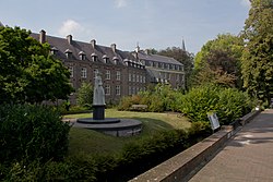
The construction of the castle began in 1391. Till 1794 the castle was used by the German Order. In 1916 the castle was used as a mission monastic. The castle has a Castle Park in English style. In the park there is also the liberation monument from World War II.
Museums
Het Boerenbondsmuseum is a museum in Gemert. In this museum there are some objects and some buildings about the farmerpopulation near Gemert around 1900.
↑ "Postcodetool for 5421AA". Actueel Hoogtebestand Nederland (in Dutch). Het Waterschapshuis. Archived from the original on 21 September 2013. Retrieved 16 April 2022.
This page is based on this Wikipedia article Text is available under the CC BY-SA 4.0 license; additional terms may apply. Images, videos and audio are available under their respective licenses.