
Scouting in Mississippi has a long history, from the 1910s to the present day, serving thousands of youth in programs that suit the environment in which they live.

Natchez is the only city in and the county seat of Adams County, Mississippi, United States. The population was 14,520 at the 2020 census. Located on the Mississippi River across from Vidalia, Louisiana, Natchez was a prominent city in the antebellum years, a center of cotton planters and Mississippi River trade.
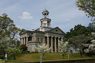
Vicksburg is a historic city in Warren County, Mississippi, United States. It is the county seat. The population was 21,573 at the 2020 census. Located on a high bluff on the east bank of the Mississippi River across from Louisiana, Vicksburg was built by French colonists in 1719. The outpost withstood an attack from the native Natchez people. It was incorporated as Vicksburg in 1825 after Methodist missionary Newitt Vick. The area that is now Vicksburg was long occupied by the Natchez Native Americans as part of their historical territory along the Mississippi. The first Europeans who settled the area were French colonists who built Fort Saint Pierre in 1719 on the high bluffs overlooking the Yazoo River at present-day Redwood. They conducted fur trading with the Natchez and others, and started plantations. During the American Civil War, it was a key Confederate river-port, and its July 1863 surrender to Ulysses S. Grant, along with the concurrent Battle of Gettysburg, marked the turning-point of the war.

Pinckney's Treaty, also known as the Treaty of San Lorenzo or the Treaty of Madrid, was signed on October 27, 1795, by the United States and Spain.

The Natchez Trace, also known as the Old Natchez Trace, is a historic forest trail within the United States which extends roughly 440 miles (710 km) from Nashville, Tennessee, to Natchez, Mississippi, linking the Cumberland, Tennessee, and Mississippi rivers.

The Natchez Trace Parkway is a limited-access national parkway in the Southeastern United States that commemorates the historic Natchez Trace and preserves sections of that original trail. Its central feature is a two-lane road that extends 444 miles (715 km) from Natchez, Mississippi, to Nashville, Tennessee. Access to the parkway is limited, with more than 50 access points in Mississippi, Alabama, and Tennessee. The southern end of the route is in Natchez at its intersection with Liberty Road, and the northern end is northeast of Fairview, Tennessee, in the suburban community of Pasquo, at an intersection with Tennessee State Route 100. In addition to Natchez and Nashville, larger cities along the route include Jackson and Tupelo, Mississippi, and Florence, Alabama.

Manchac is an unincorporated community in Tangipahoa Parish, Louisiana, United States.

The Natchez Trace Trail is a designated National Scenic Trail in the United States, whose route generally follows sections of the 444-mile (715 km) Natchez Trace Parkway through the states of Tennessee, Alabama, and Mississippi. The Natchez Trace Trail is not a long, continuous footpath, as is the case with other national scenic trails ; rather, only a limited number of trail segments along the route, currently over 60 miles (97 km) of trail, have been developed for hiking and horseback riding. Moreover, the Natchez Trace Trail, unlike many others that rely heavily on volunteers for trail construction and maintenance, is managed and maintained by the National Park Service. Sections of the trail follow along the Natchez Trace Parkway road shoulder, and cross county and state roads. It was originally intended to be longer and follow most of the Natchez Trace Parkway, but only a portion was built.

The Natchez District was one of two areas established in the Kingdom of Great Britain's West Florida colony during the 1770s – the other being the Tombigbee District. The first Anglo settlers in the district came primarily from other parts of British America. The district was recognized to be the area east of the Mississippi River from Bayou Sara in the south and Bayou Pierre in the north.
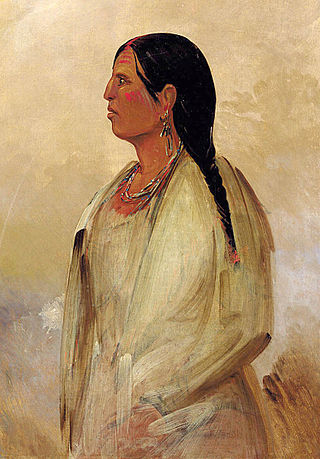
Indigenous peoples of the Southeastern Woodlands, Southeastern cultures, or Southeast Indians are an ethnographic classification for Native Americans who have traditionally inhabited the area now part of the Southeastern United States and the northeastern border of Mexico, that share common cultural traits. This classification is a part of the Eastern Woodlands. The concept of a southeastern cultural region was developed by anthropologists, beginning with Otis Mason and Franz Boas in 1887. The boundaries of the region are defined more by shared cultural traits than by geographic distinctions. Because the cultures gradually instead of abruptly shift into Plains, Prairie, or Northeastern Woodlands cultures, scholars do not always agree on the exact limits of the Southeastern Woodland culture region. Shawnee, Powhatan, Waco, Tawakoni, Tonkawa, Karankawa, Quapaw, and Mosopelea are usually seen as marginally southeastern and their traditional lands represent the borders of the cultural region.

Jackson's Military Road was a 19th-century route connecting Nashville, Tennessee, with New Orleans, Louisiana. After the War of 1812, Congress appropriated funds in 1816 to build and improve this road. It was completed in 1820. The road was named for then General Andrew Jackson, hero of the United States victory at the Battle of New Orleans against British forces.

Seven segments of the historic Natchez Trace are listed on the National Register of Historic Places (NRHP). Also there are additional NRHP-listed structures and other sites along the Natchez Trace, which served the travelers of the trace and survive from the era of its active use.

U.S. Highway 65 (US 65) is a part of the United States Numbered Highway System that spans 966 miles (1,555 km) from Clayton, Louisiana to Albert Lea, Minnesota. Within the state of Louisiana, the highway travels 100.77 miles (162.17 km) from the national southern terminus at US 425/LA 15 in Clayton to the Arkansas state line north of Lake Providence.
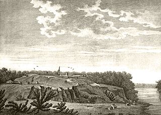
The Natchez revolt, or the Natchez massacre, was an attack by the Natchez Native American people on French colonists near present-day Natchez, Mississippi, on November 28, 1729. The Natchez and French had lived alongside each other in the Louisiana colony for more than a decade prior to the incident, mostly conducting peaceful trade and occasionally intermarrying. After a period of deteriorating relations and warring, Natchez leaders were provoked to revolt when the French colonial commandant, Sieur de Chépart, demanded land from a Natchez village for his own plantation near Fort Rosalie. The Natchez plotted their attack over several days and managed to conceal their plans from most of the French; colonists who overheard and warned Chépart of an attack were considered untruthful and were punished. In a coordinated attack on the fort and the homesteads, the Natchez killed almost all of the Frenchmen, while sparing most of the women and enslaved Africans. Approximately 230 colonists were killed overall, and the fort and homes were burned to the ground.

Silas Dinsmoor was an appointed U.S. Agent to the Cherokee (1794–1798) and to the Choctaw (1801–1813). He later served as a surveyor in Alabama before eventually retiring to Boone County, Kentucky, where he is buried at the Dinsmore Homestead.
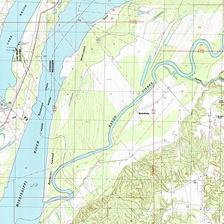
Bruinsburg is an extinct settlement in Claiborne County, Mississippi, United States. Founded when the Natchez District was part of West Florida, the settlement was one of the end points of the Natchez Trace land route from Nashville to the lower Mississippi River valley.

Bayou Pierre is a river in Louisiana and Mississippi, United States. It is a tributary of the Mississippi River merging just downstream from the town of St. Joseph, Louisiana on the opposite bank.
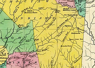
The Robinson Road is a historical road in the US state of Mississippi. It ran from Columbus to the Natchez Trace via Agency, Louisville, and Carthage. From the Natchez Trace intersection, the road continued to Canton; and the road's southwestern terminus was near Ridgeland, ten miles north of Jackson.

Andrew Jackson bought and sold slaves from 1788 until 1844, both for use on his plantations and for short-term gain through slave arbitrage. He was most active in the interregional slave trade, which he euphemistically termed "the mercantile transactions," from the 1790s through the 1810s. Available evidence shows that speculator Jackson trafficked people between his hometown of Nashville, Tennessee, and the slave markets of the lower Mississippi River valley.

Fort Nogales was a 18th-century Spanish colonial fort in West Florida, at the confluence of the Yazoo River and the Mississippi River. The fort stood at the site of present-day Vicksburg, Warren County, Mississippi, United States.
![General Carols Road [sic] on the 1819 map by John Melish Map of Mississippi - constructed from the surveys in the General Land Office and other documents LOC 2001626031.jpg](http://upload.wikimedia.org/wikipedia/commons/thumb/7/7d/Map_of_Mississippi_-_constructed_from_the_surveys_in_the_General_Land_Office_and_other_documents_LOC_2001626031.jpg/220px-Map_of_Mississippi_-_constructed_from_the_surveys_in_the_General_Land_Office_and_other_documents_LOC_2001626031.jpg)


