General Sarmiento Partido

Last updated
Partido de General Sarmiento
Partido of Buenos Aires Province
1889–1995
GralSarmiento lBUE.PNG
Map of General Sarmiento Province highlighted in black.
Capital San Miguel
Population 
 1991
652,969 [1] [2]
History 
 Established
18 October 1889
 Disestablished
10 December 1995
Succeeded by
José C. Paz Partido Blank.png
Malvinas Argentinas Partido Blank.png
San Miguel Partido Blank.png

General Sarmiento (Spanish : Partido de General Sarmiento) was one of the partidos of the province of Buenos Aires, located in the northwest of the greater Buenos Aires urban area.

Contents

History

The creation of General Sarmiento Partido was announced on 18 October 1889 by Provincial Law No. 2,198, comprising the towns of San Miguel, Bella Vista and territories of the partidos of Pilar and Las Conchas (now Tigre).

In 1994 Provincial Law No. 11,551 / 94.4 was enacted, through which it was decided to legally dissolve the General Sarmiento Partido and create the José C. Paz, Malvinas Argentinas and San Miguel Partidos in its territory until then. As the second of the new administrative jurisdictions also received a small portion of only 3 km2 from the partido of Pilar. As compensation for this loss, the entire town of Del Viso was incorporated into the jurisdiction of Pilar.

General Sarmiento officially ceased to exist on 10 December 1995, the day the municipal activities of the three new parties began to function. However, the National University of General Sarmiento (UNGS), which for its part, was founded in 1992 and whose main headquarters became located in the Malvinas Argentinas Partido, continues to maintain its old name.

Demographics

Its population, which was already 502,926 inhabitants, according to the 1980 census, with an average density of 2,566 inhabitants/km2), in 1991, the population was recorded to be 652,969. (3,331 pop./km2). [1] It was then lowered to 638,486, due to the post-census territorial readjustment.

For their part, the three partidos into which it was divided had a combined population of 743,585. (3,853 pop./km2) According to the 2001 census, it had a population of 864,546, according to the census carried out at the end of 2010. [3]

If it continued to exist, and if it maintained the growth shown between 2001 and 2010, General Sarmiento would have had about 971,518 inhabitants by mid-2020 (4,938 inhabitants/km2), so it would be the second most populous partido in the Greater Buenos Aires agglomeration, after La Matanza.

Related Research Articles

<span class="mw-page-title-main">Buenos Aires Province</span> Province of Argentina

Buenos Aires, officially the Buenos Aires Province, is the largest and most populous Argentine province. It takes its name from the city of Buenos Aires, the capital of the country, which used to be part of the province and the province's capital until it was federalized in 1880. Since then, in spite of bearing the same name, the province does not include Buenos Aires city, though it does include all other parts of the Greater Buenos Aires metropolitan area. The capital of the province is the city of La Plata, founded in 1882.

<span class="mw-page-title-main">La Plata</span> Capital city of Buenos Aires Province, Argentina

La Plata is the capital city of Buenos Aires Province, Argentina. According to the 2022 census, the Partido has a population of 772,618 and its metropolitan area, the Greater La Plata, has 938,287 inhabitants. It is located 9 kilometers inland from the southern shore of the Río de la Plata estuary.

<span class="mw-page-title-main">Salta Province</span> Province of Argentina

Salta is a province of Argentina, located in the northwest of the country. Neighboring provinces are from the east clockwise Formosa, Chaco, Santiago del Estero, Tucumán and Catamarca. It also surrounds Jujuy. To the north it borders Bolivia and Paraguay and to the west lies Chile.

<span class="mw-page-title-main">Greater Buenos Aires</span> Urban agglomeration in Argentina

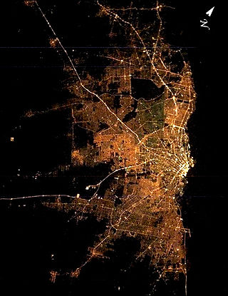
Greater Buenos Aires, also known as the Buenos Aires Metropolitan Area, refers to the urban agglomeration comprising the Autonomous City of Buenos Aires and the adjacent 24 partidos (districts) in the Province of Buenos Aires. Thus, it does not constitute a single administrative unit. The conurbation spreads south, west and north of Buenos Aires city. To the east, the River Plate serves as a natural boundary.

<span class="mw-page-title-main">Vicente López Partido</span> Partido in Argentina

Vicente López is a partido in the Buenos Aires metropolitan area, Buenos Aires Province, Argentina. It is one of the country´s most affluent municipalities.

<span class="mw-page-title-main">Malvinas Argentinas Partido</span> Department in Argentina

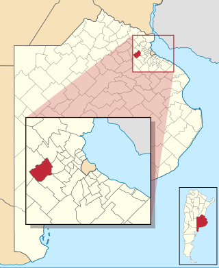
Malvinas Argentinas Partido is a partido in Buenos Aires Province, Argentina, in the Gran Buenos Aires urban area. It has an area of 63.8 km2 (24.6 sq mi) and according to the preliminary results of the 2010 Census, the population was 321,833 inhabitants.. Its capital is Los Polvorines, and its largest city is Grand Bourg.

<span class="mw-page-title-main">La Matanza Partido</span> Partido in Argentina

La Matanza is a partido located in the urban agglomeration of Greater Buenos Aires, Buenos Aires Province, Argentina.

<span class="mw-page-title-main">National Route 9 (Argentina)</span> Highway in Argentina

National Route 9 is a major road in Argentina, which runs from the center-east to the northwest of the country, crossing the provinces of Buenos Aires, Santa Fe, Córdoba, Santiago del Estero, Tucumán, Salta and Jujuy. It starts on Avenida General Paz, which marks the border between the Autonomous City of Buenos Aires and the surrounding province of the same name, and ends at the Horacio Guzmán International Bridge, on the La Quiaca River, traversing 1,967 km (1,222 mi). The road is a limited access motorway from Buenos Aires to Rosario.

<span class="mw-page-title-main">Morón Partido</span> Department in Argentina

Morón is a partido of the Buenos Aires Province, Argentina. Located in the Greater Buenos Aires urban area, its head town is Morón which is located around 17 km (11 mi) from Buenos Aires.

<span class="mw-page-title-main">Adolfo Alsina Partido</span> Department in Buenos Aires, Argentina

Adolfo Alsina is a western partido of the Buenos Aires Province, Argentina, found at coordinates 37°10′S62°44′W.

<span class="mw-page-title-main">General Rodríguez Partido</span> Department in Argentina

General Rodríguez is a western partido of Buenos Aires Province, in Argentina. It is a district on the far western outskirts of Greater Buenos Aires.

<span class="mw-page-title-main">Cañuelas Partido</span> Department in Argentina

Cañuelas Partido is a partido of Buenos Aires Province in Argentina. It has a population of 42,575 in an area of 1,200 km2 (460 sq mi), and its administrative centre is Cañuelas, which has a population of around 24,380.

<span class="mw-page-title-main">Tres de Febrero Partido</span> Partido in Buenos Aires Province, Argentina

Tres de Febrero is a partido of the Greater Buenos Aires conurbation area in the Buenos Aires Province, Argentina.

<span class="mw-page-title-main">San Miguel, Buenos Aires</span> City in Buenos Aires Province, Argentina

San Miguel is a city in the northwest region of Greater Buenos Aires, 30 km from the City of Buenos Aires. San Miguel is the county seat of San Miguel Partido, and has been a part of Greater Buenos Aires since the early 2000s. The number of inhabitants was 157,532 according to the 2001 census.

<span class="mw-page-title-main">Esteban Echeverría Partido</span> Department in Argentina

Esteban Echeverría Partido is a partido in the Gran Buenos Aires urban area, in Buenos Aires Province in Argentina.

<span class="mw-page-title-main">San Miguel Partido</span> Department in Argentina

San Miguel Partido is a partido in the Greater Buenos Aires urban area of Buenos Aires Province in Argentina.

Conesa is a town in San Nicolás Partido, Buenos Aires Province, Argentina. It is located next to National Route 188, 35 km from San Nicolás de los Arroyos, 43 km from Pergamino and a few kilometers from the border with Santa Fe Province, bordering the Santa Fe town of Juan Bernabé Molina.

References

  1. 1 2 "Provincia según departamento. Población, superficie y densidad. Años 1991 y 2001". Archived from the original on 24 June 2017. Retrieved 22 September 2010.
  2. "Provincia según localidad. Población censada en 1991 y población por sexo en 2001". Archived from the original on 28 September 2007. Retrieved 22 September 2010.
  3. "2010 Census provisional results". Archived from the original on 2012-09-01. Retrieved 2020-09-28.