
Charleston is the most populous city in the U.S. state of South Carolina, the county seat of Charleston County, and the principal city in the Charleston metropolitan area. The city lies just south of the geographical midpoint of South Carolina's coastline on Charleston Harbor, an inlet of the Atlantic Ocean formed by the confluence of the Ashley, Cooper, and Wando rivers. Charleston had a population of 150,227 at the 2020 census. The population of the Charleston metropolitan area, comprising Berkeley, Charleston, and Dorchester counties, was estimated to be 849,417 in 2023. It ranks as the third-most populous metropolitan statistical area in the state, and the 71st-most populous in the United States.

William Childs Westmoreland was a United States Army general, most notably the commander of United States forces during the Vietnam War from 1964 to 1968. He served as Chief of Staff of the United States Army from 1968 to 1972.

Charleston County is located in the U.S. state of South Carolina along the Atlantic coast. As of the 2020 census, the population was 408,235, making it the third-most populous county in South Carolina. Its county seat is Charleston. It is also the largest county in the state by total area, although Horry County has a larger land area. The county was created in 1800 by an act of the South Carolina State Legislature.
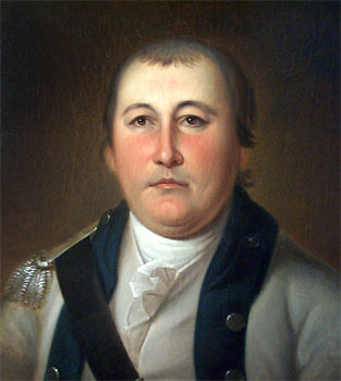
William Washington was a cavalry officer of the Virginia militia and Continental Army during the American Revolutionary War, who also served on General George Washington's staff during the naval war with France in 1798 and held a final rank of brigadier general. Primarily known as a commander of light dragoons, he led mounted troops in a number of notable battles in the Carolinas during the campaigns of 1780 and 1781. Following the conflict, this William Washington moved to South Carolina, where he married and served in the state legislature as well as led the Seventh Brigade of the South Carolina militia. Cavalry Commander William Washington of Stafford County and South Carolina has often been confused with his distant cousin William Augustine Washington, also a Revolutionary War patriot and planter, who served as a delegate representing Westmoreland County, Virginia.

James Burrows Edwards was an American politician and administrator from South Carolina. He was the first Republican to be elected governor of South Carolina since the post-Civil War Reconstruction era in the 1870s. He later served as the U.S. secretary of energy under Ronald Reagan.

The Ashley River is a blackwater and tidal river in South Carolina, rising from the Wassamassaw and Great Cypress Swamps in western Berkeley County. It consolidates its main channel about five miles west of Summerville, widening into a tidal estuary just south of Fort Dorchester. The river then flows for approximately 17 mi (27 km) along the historical banks of the City of North Charleston before reaching peninsular Charleston. The much wider Ashley joins the Cooper River off the Battery in Charleston to form Charleston Harbor before discharging into the Atlantic Ocean. As of 2012 the land around the Ashley River is mostly undeveloped.

The Cooper River is a mainly tidal river in the U.S. state of South Carolina. The cities of Mt. Pleasant, Charleston, North Charleston, Goose Creek, Moncks Corner, and Hanahan are located along the river. Short and wide, the river is joined first by the blackwater East Branch and then farther downstream at the tidal Wando River. Almost immediately thereafter, the Cooper River widens into its estuary and unites with the Ashley River to form the Charleston Harbor.

Interstate 526 (I-526) is a 19.56-mile (31.48 km) auxiliary route of I-26, providing a partial beltway around Charleston, South Carolina, in the United States. The route serves several purposes, firstly, as a bypass for through traffic on U.S. Route 17 (US 17) to avoid downtown Charleston, and, secondly, for traffic on I-26 bound for the coastal towns located north and south of Charleston. The route is not yet complete, as the western terminus it is planned for the route to be extended an additional 10 miles (16 km). After the eastern terminus, the roadway continues as a short business route, known as Interstate 526 Business.
The Charleston and Savannah Railway was a 19th-century American railroad serving the coastal states of South Carolina and Georgia and running through part of the South Carolina Lowcountry. Its name varied slightly over time:

South Carolina Highway 61 (SC 61) is a 67-mile-long (108 km) state highway in the U.S. state of South Carolina. The highway is designated on a north–south direction, but physically travels in an east–west direction, from SC 30 in Charleston to U.S. Route 78 (US 78) near Branchville. The portion of SC 61 from Church Creek Bridge and 10 miles (16 km) north is designated a National Scenic Byway.

The 1974 South Carolina gubernatorial election was held on November 5, 1974 to select the governor of the state of South Carolina. Initially considered a longshot candidate, Republican James B. Edwards defeated Democrat W. J. Bryan Dorn with a narrow majority of the vote.

Magnolia Plantation and Gardens is a historic house with gardens located on the Ashley River at 3550 Ashley River Road west of Ashley, Charleston County, South Carolina. It is one of the oldest plantations in the South, and listed on the National Register of Historic Places. Magnolia Plantation is located near Charleston and directly across the Ashley River from North Charleston. The house and gardens are open daily; an admission fee is charged.

West Ashley, or more formally, west of the Ashley, is one of the six distinct areas of the city proper of Charleston, South Carolina. As of July 2022, its estimated population was 83,996. Its name is derived from the fact that the land is west of the Ashley River.

Interstate 26 (I-26) is a South Carolina Interstate highway running generally east–west from near Landrum, in Spartanburg County, to U.S. Route 17 (US 17), in Charleston, South Carolina. It is also the longest Interstate Highway in South Carolina.

This is a list of the National Register of Historic Places listings in Charleston County, South Carolina.

U.S. Highway 17 (US 17) is a part of the United States Numbered Highway System that runs north–south from Punta Gorda, Florida to Winchester, Virginia. In South Carolina, it is a 221-mile (356 km) major highway that travels near the Atlantic Ocean. Beginning from the Georgia state line at the Savannah River, US 17 enters South Carolina in Jasper County, where it intersects with Interstate 95 (I-95). The route goes through Hardeeville. It merges with I-95 until Point South, then heads east into Beaufort County, through the ACE Basin, and eventually reaches Charleston. There, US 17 crosses the Ashley and Cooper rivers, crossing the Arthur Ravenel Jr. Bridge and becoming a major route through Mount Pleasant. Continuing through the Francis Marion National Forest, it reaches Georgetown. Then it follows the Grand Strand, bypassing Myrtle Beach before entering North Carolina near Calabash.

South Carolina Highway 700 (SC 700) is a 20.380-mile (32.798 km) state highway in the U.S. state of South Carolina. Known for most of its length as Maybank Highway, the state highway travels from a dead end in Rockville east to U.S. Route 17 (US 17) in Charleston. SC 700 connects Charleston with James Island, Johns Island, and Wadmalaw Island in southwestern Charleston County.
The West Ashley Greenway is a rail trail in Charleston, South Carolina. It stretches across the West Ashley neighborhood from Main Road in the west to Folly Road in the east. It is a straight and mostly paved path utilized for walking, jogging, roller skating, and off-street cycling. The distance of the main trail currently covers 8.8 miles (14.2 km). It is a contributing segment of the East Coast Greenway. In 2019, the U.S. Department of Transportation gave the city of Charleston a $18 million grant to build a pedestrian bridge across the Ashley River connecting West Ashley to downtown Charleston. The planned pedestrian bridge may eventually connect with the Lowcountry Lowline.

Ashley Hall Plantation is a historic plantation complex located on the Ashley River near West Ashley, Charleston County, South Carolina. The plantation was established in the early 1670s by Stephen Bull. The property includes a small tabby-walled house with a 20th-century second story addition, the ruins of the Georgian plantation house (1704) which was burned in 1865 to prevent its destruction by Union forces, a monument to the second Governor William Bull, two prehistoric Indian archaeological sites, and two 18th century well sites associated with the plantation. The tabby house is considered one of the oldest standing houses in the state.
The architecture of Charleston, the largest city in the US state of South Carolina, has English and Barbadian influences.

