James Bay is a large body of water located on the southern end of Hudson Bay in Canada. It borders the provinces of Quebec and Ontario, and is politically part of Nunavut. Its largest island is Akimiski Island.
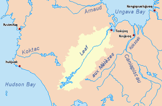
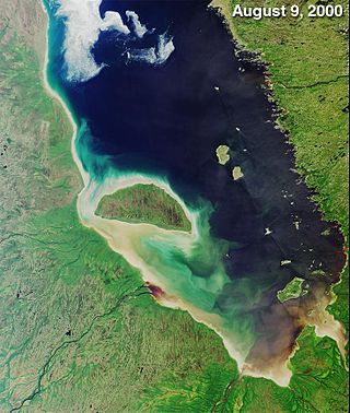
Leaf River is a river in northern Quebec, Canada, at the northern limit of the tree line. It flows from Lake Minto northeast through the Ungava Peninsula into Leaf Bay off Ungava Bay over a distance of 480 kilometres (300 mi). At the head of Leaf Bay is the Inuit community of Tasiujaq.
The Gatineau River is a river in western Quebec, Canada, which rises in lakes north of the Baskatong Reservoir and flows south to join the Ottawa River at the city of Gatineau, Quebec. The river is 386 kilometres (240 mi) long and drains an area of 23,700 square kilometres (9,200 sq mi).

The Rupert River is one of the largest rivers in Quebec, Canada. From its headwaters in Lake Mistassini, the largest natural lake in Quebec, it flows 556 kilometres (345 mi) west into Rupert Bay on James Bay. The Rupert drains an area of 43,400 square kilometres (16,800 sq mi).
The Caniapiscau River is a tributary of the Koksoak River in Nunavik, Quebec, Canada. In Cree the name of the river means rocky point.

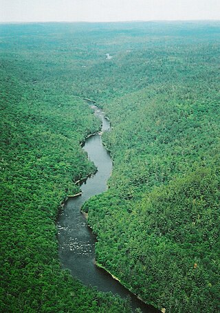
The Magpie River, Moteskikan Hipu, Mutehekau Hipu, Pmotewsekaw Sipo, Rivière Magpie (French), it flows from north to south, emptying into Magpie Bay, Gulf of St. Lawrence, in Rivière-Saint-Jean municipality, Minganie RCM, Côte-Nord, Quebec, Canada.
The Dumoine River is a river in western Quebec with its source in Machin Lake near La Vérendrye Wildlife Reserve. From Dumoine Lake, the river flows almost due south off the Canadian Shield and empties into the Ottawa River, just west of Rapides-des-Joachims, Quebec, or Rolphton, Ontario. The river is 129 kilometres (80 mi) long and drains a watershed of 5,380 square kilometres (2,080 sq mi). This relatively short river compared to its drainage area indicates that the Dumoine has a strong current and many steep-gradient rapids.
The Lièvre River is a river in western Quebec which flows south from the Mitchinamécus reservoir and empties into the Ottawa River at Masson-Angers. The river is 330 kilometres (210 mi) long and drains an area of 10,400 square kilometres (4,000 sq mi). The river's name is an adaptation of its former French name Riviere aux Lièvres, "River of the Hares".

Route 117, the Trans Canada Highway Northern Route, is a provincial highway within the Canadian province of Quebec, running between Montreal and the Quebec/Ontario border where it continues as Highway 66 east of McGarry, Ontario. It is an important road since it is the only direct route between southern Quebec and the Abitibi-Témiscamingue region.

The Harricana River is a river in western Quebec and northeastern Ontario, Canada. It is 533 kilometres (331 mi) long, has a drainage area of 29,300 square kilometres (11,300 sq mi), and has a mean discharge of 570 cubic metres per second (20,000 cu ft/s). While 80% of its drainage area is in Quebec, the river flows for a short distance through Ontario before it ends in Hannah Bay off James Bay.

The Great Whale River is a river in Nunavik, Quebec, Canada. It flows from Lac Saint-Luson through Lac Bienville west to Hudson Bay. While the lower section of the river has a very powerful current, with many waterfalls and rapids, the upper section consists of a series of lakes interconnected by steep rapids and ledges.

The Baskatong Reservoir is a man-made lake in western Quebec, Canada. It was formed following the construction of the Mercier Dam in 1927 and has an area of 413 km2. Since 2007, a 55 MW generating station is in operation at the site of the dam, the reservoir also being used to control the flow of the Gatineau River for several hydroelectric generating stations downstream.

The Cabonga Reservoir is a man-made lake in central Quebec, Canada, with a total surface area of 677 square kilometres (261 sq mi) and a net area of 484 square kilometres (187 sq mi). It is located on the boundary between the unorganized territories of Lac-Pythonga and Réservoir-Dozois, and fully within the La Vérendrye Wildlife Reserve. The First Nations reserve of Rapide Lake is on its western shores.

Lac-Ashuapmushuan is an unorganized territory in the Canadian province of Quebec, Canada, located in the regional county municipality of Le Domaine-du-Roy. The region had a population of 140 as of the Canada 2021 Census, and covered a land area of 14,684.28 km2. It is home to the Ashuapmushuan Wildlife Reserve.

Mattawa Bay is a freshwater body of the southwestern part of the Gouin Reservoir in the territory of the town of La Tuque, in the Mauricie administrative region, in the province of Quebec, in Canada.
The Toulnustouc River is a tributary of the Manicouagan River in Rivière-aux-Outardes, Côte-Nord, Quebec, Canada. It is dammed to form Lake Sainte-Anne, which regulates water supply to the huge hydroelectric plants near the mouth of the Manicouagan and also feeds the Toulnustouc generating station with a capacity of 526 MW, which has been operational since 2005.

The Nabisipi River is a salmon river in the Côte-Nord region of Quebec, Canada. It flows into the Gulf of Saint Lawrence

The Pashashibou River is a river in the Côte-Nord region of Quebec, Canada. It flows into the Gulf of Saint Lawrence.
The Musquanousse River is a salmon river in the Côte-Nord region of Quebec, Canada. It flows south and empties into the Gulf of Saint Lawrence.

