State Route 34 (SR 34) is a 43.6-mile-long (70.2 km) state highway that travels west-to-east through portions of Heard and Coweta counties in the west-central part of the U.S. state of Georgia. The highway connects the Alabama state line southwest of Franklin with the Peachtree City area, via Franklin and Newnan.

State Route 255 (SR 255) is a 19.7-mile-long (31.7 km) S-shaped state highway located in the North Georgia mountains section of the U.S. state of Georgia. It travels through White and Habersham counties.
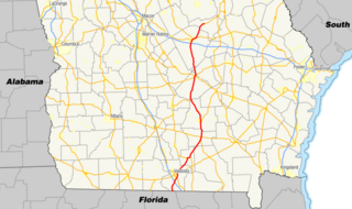
State Route 31 (SR 31) is a 166.9-mile-long (268.6 km) state highway that travels south-to-north through portions of Lowndes, Lanier, Clinch, Atkinson, Coffee, Telfair, Wheeler, Dodge, Laurens, and Johnson counties in the south-central part of the U.S. state of Georgia. The highway connects the Florida state line, south of Clyattville with Wrightsville, via Valdosta, Douglas, and Dublin.
State Route 273 (SR 273) is a 17.2-mile-long (27.7 km) west-east state highway located in the southwestern part of the U.S. state of Georgia. It travels within Early and Miller counties.

State Route 272 (SR 272) is a 15.4-mile-long (24.8 km) north–south state highway located in the east-central part of the U.S. state of Georgia. Its path is entirely within Washington County.

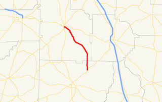
State Route 271 (SR 271) is a 7.6-mile-long (12.2 km) east–west state highway located in the west-central part of the U.S. state of Georgia. Its route is within Schley and Sumter counties.

State Route 270 (SR 270) is a 12.7-mile-long (20.4 km) east–west state highway located in the southern part of the U.S. state of Georgia. Its route is within Mitchell and Colquitt counties.

State Route 268 (SR 268) is a 22.9-mile-long (36.9 km) southwest–northeast state highway located in the south-central part of the U.S. state of Georgia. It travels within portions of Coffee and Jeff Davis counties.

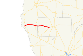
State Route 266 (SR 266) is a 18.2-mile-long (29.3 km) east–west state highway located in the southwestern part of the U.S. state of Georgia. Its path is within Clay and Randolph counties.

State Route 264 (SR 264) is a 2.7-mile-long (4.3 km) northwest-southeast state highway located in the eastern part of the Atlanta metropolitan area in the U.S. state of Georgia. Its route is entirely within Gwinnett County.

State Route 262 (SR 262) is a 44.4-mile-long (71.5 km) L-shaped state highway located in the southwestern part of the U.S. state of Georgia. It travels within portions of within Decatur and Mitchell counties, and skims the border of Grady County.
State Route 256 (SR 256) is a 21.0-mile-long (33.8 km) north–south state highway located in the southern part of the U.S. state of Georgia. Its route is within Colquitt and Worth counties.

State Route 254 (SR 254) is a 10.8-mile-long (17.4 km) southwest-northeast state highway located in the northeastern part of the U.S. state of Georgia. It travels through portions of Hall and White counties.
State Route 251 (SR 251) is a 13.5-mile-long (21.7 km) south–north state highway located in the east-central part of the U.S. state of Georgia. It travels entirely within McIntosh County.

State Route 242 (SR 242) is a 25.0-mile-long (40.2 km) east–west state highway located in the central part of the U.S. state of Georgia. It travels through portions of Washington and Jefferson counties.

State Route 241 (SR 241) is a 5.6-mile-long (9.0 km) southwest-northeast state highway located in the southwestern part of the U.S. state of Georgia. It exists entirely within Decatur County.

State Route 240 (SR 240) is a 37.6-mile-long (60.5 km) southeast-northwest state highway located in the west-central part of the U.S. state of Georgia. It travels through portions of Macon, Schley, Marion, and Talbot counties.

State Route 232 (SR 232) is a 14.3-mile-long (23.0 km) east–west state highway located in the east-central part of the U.S. state of Georgia. It travels through west-central Columbia County and northeastern Richmond County. At its western end, it is a fairly rural highway, but its eastern end is an urban corridor of the Augusta metropolitan area. It connects Appling with Evans, Martinez, and Augusta.

State Route 103 (SR 103) is a 13.9-mile-long (22.4 km) state highway in the west-central part of the U.S. state of Georgia. The highway travels from a point northwest of Mulberry Grove northwest to West Point. The highway used to travel through Muscogee, Chattahoochee, and Marion counties, but was truncated through Fort Benning. Its former path was redesignated as parts of SR 137 Spur, SR 357 and SR 219.

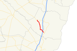
State Route 227 (SR 227) is a 2.2-mile-long (3.5 km) connecting state highway that travels south-to-north through portions of Treutlen County in the east-central part of the U.S. state of Georgia.