Mount Umbriel is a peak, rising to about 1,500 m, overlooking the head of Venus Glacier on the east coast of Alexander Island, Antarctica, with the east face of the mountain overlooking the George VI Ice Shelf that occupies George VI Sound. The mountain was first mapped by Searle of the Falkland Islands Dependencies Survey in 1960, from air photos taken by the Ronne Antarctic Research Expedition in 1947-48. Named by the United Kingdom Antarctic Place-Names Committee from association with nearby Uranus Glacier, Umbriel being one of the satellites of the planet Uranus, the seventh planet of the Solar System.
Uranus Glacier is a glacier on the east coast of Alexander Island, Antarctica, 30 kilometres long and 10 km (6 mi) wide at its mouth, flowing east into George VI Sound immediately south of Fossil Bluff. Along the south face of the glacier is an east–west escarpment called Kuiper Scarp.
Adams Nunatak is a nunatak on the south side of Neptune Glacier, 6 miles (10 km) west of Cannonball Cliffs, and lies about 7.4 miles (12 km) inland from George VI Sound in eastern Alexander Island, Antarctica. Mapped by Directorate of Overseas Surveys from satellite imagery supplied by NASA in cooperation with U.S. Geological Survey. Named by United Kingdom Antarctic Place-Names Committee (UK-APC) in association with Neptune Glacier after John Couch Adams, the Cambridge mathematician who deduced the existence of the planet Neptune.
The George VI Ice Shelf is an extensive ice shelf that occupies George VI Sound which separates Alexander Island from Palmer Land in Antarctica. The ice shelf extends from Ronne Entrance, at the southwest end of the sound, to Niznik Island, about 30 nautical miles (56 km) south of the north entrance between Cape Brown and Cape Jeremy. It was named by the UK Antarctic Place-Names Committee in association with George VI Sound.
The Eklund Islands are a group of islands which rise through the ice near the southwest end of George VI Sound towards the south of the Antarctic Peninsula.
Ares Cliff is a cliff in Antarctica. It is formed of pale-colored sandstone and rises to about 500 metres (1,600 ft) east of Mars Glacier and 1 nautical mile (2 km) north of Two Step Cliffs on the east side of Alexander Island. It was mapped from trimetrogon air photography taken by the Ronne Antarctic Research Expedition, 1947–48, and from survey by the Falkland Islands Dependencies Survey, 1948–50, and named by the UK Antarctic Place-Names Committee in association with Mars Glacier after the Greek god of war, Ares.

Armstrong Glacier is a glacier flowing from the south side of Mount Bagshawe westward into George VI Sound. It provides the only known safe route for mechanical vehicles from George VI Sound to the Palmer Land plateau. It was named by the United Kingdom Antarctic Place-Names Committee for Edward B. Armstrong, British Antarctic Survey surveyor at Stonington Island, 1964–65.
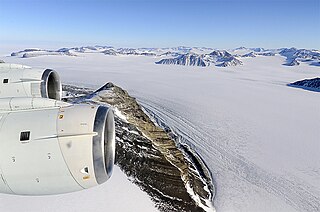
The Cannonball Cliffs are cliffs at the south side of the terminus of Neptune Glacier on the east side of Alexander Island, Antarctica. The feature consists of two east-west ridges about 500 metres (1,600 ft) high, joined by a narrow north-south ridge. The feature was mapped from trimetrogon air photography taken by the Ronne Antarctic Research Expedition, 1947–48, and from survey by the Falkland Islands Dependencies Survey, 1948–50. The name was applied by the UK Antarctic Place-Names Committee for the sandstone in the area, which contains numerous spherical, brown concretions known as "cannon-ball" concretions.
Conchie Glacier is a glacier on the west coast of Palmer Land which flows southwest into George VI Sound between the Batterbee Mountains and the Steeple Peaks. It was named by the UK Antarctic Place-Names Committee for Flight-Lieutenant Bertie J. Conchie, Royal Air Force, pilot with the British Antarctic Survey, 1969–75.
Neptune Glacier is a glacier on the east coast of Alexander Island, Antarctica, 12 nautical miles (22 km) long and 4 nautical miles (7 km) wide, flowing east into George VI Sound and the George VI Ice Shelf to the south of Triton Point. Although Neptune Glacier is not located within the mountain range Planet Heights, the glaciers name derives from the mountain range along with many other nearby glaciers named after planets of the Solar System. There are also other nearby landforms named in association with these glaciers. The glacier was first sighted from the air by Lincoln Ellsworth on November 23, 1935, and roughly mapped from photos obtained on that flight by W.L.G. Joerg. The mouth of the glacier was positioned in 1936 by the British Graham Land Expedition (BGLE). Named by the United Kingdom Antarctic Place-Names Committee (UK-APC) for the planet Neptune following a Falkland Islands Dependencies Survey (FIDS) survey in 1949. The head of the glacier was mapped from air photos taken by the Ronne Antarctic Research Expedition (RARE), 1947–48, by Searle of the FIDS in 1960.
Planet Heights is a series of summits running along an ice-free ridge, extending 24 nautical miles (44 km) in a north-south direction between the southernmost extremity of the LeMay Range and George VI Sound in the east part of Alexander Island, Antarctica. Many landforms and nearby features are named in association with this mountain range, some of these include landforms named after astronomers, satellites, planets and other things related to astrology and astrophysics. The mountain range was first mapped from air photos taken by the Ronne Antarctic Research Expedition (RARE), 1947–48, by Searle of the Falkland Islands Dependencies Survey (FIDS) in 1960. Named by the United Kingdom Antarctic Place-Names Committee (UK-APC) from association with the nearby glaciers named for planets of the solar system. The only planet that is not featured in any of these glaciers is the planet Earth, as there are no glaciers named "Earth Glacier" and this glacier does not exist.
Pluto Glacier is a glacier on the east coast of Alexander Island, Antarctica, 10 nautical miles (18 km) long and 4 nautical miles (7 km) wide, which flows east into George VI Sound to the north of Succession Cliffs. Although Pluto Glacier is not located within nearby Planet Heights, the glacier was named in association with the mountain range along with many other nearby glaciers that are named after planets of the Solar System. The glacier was first photographed from the air on November 23, 1935, by Lincoln Ellsworth and mapped from these photos by W.L.G. Joerg. Roughly surveyed in 1936 by the British Graham Land Expedition (BGLE). Named by the United Kingdom Antarctic Place-Names Committee (UK-APC) for Pluto, then considered the ninth planet of the Solar System, following Falkland Islands Dependencies Survey (FIDS) surveys in 1948 and 1949.
Mercury Glacier is a glacier on the east coast of Alexander Island, Antarctica, 5 nautical miles (9 km) long and 2 nautical miles (4 km) wide, flowing east into George VI Sound between the Waitabit Cliffs and Keystone Cliffs. The glacier was probably first sighted from a distance by Lincoln Ellsworth, who flew near it and photographed segments of this coast on November 23, 1935. It was named by the UK Antarctic Place-Names Committee for the planet Mercury following rough surveys from George VI Sound by the Falkland Islands Dependencies Survey (FIDS) in 1948 and 1949. The glacier was mapped in detail from air photos taken by the Ronne Antarctic Research Expedition, 1947–48, by D. Searle of the FIDS in 1960. Although Mercury Glacier is not located within the Planet Heights, it is named in association with the heights along with many other nearby glaciers named after planets of the Solar System.
Mars Glacier is a glacier in the southeastern corner of Alexander Island, Antarctica, 6 nautical miles (11 km) long and 2 nautical miles (4 km) wide, flowing south into the George VI Ice Shelf. The glacier lies between Two Step Cliffs and Phobos Ridge. Mars Glacier was first sighted from the air by Lincoln Ellsworth on November 23, 1935, and roughly mapped from photos obtained on that flight by W.L.G. Joerg. It was first surveyed in 1949 by the Falkland Islands Dependencies Survey and named by the UK Antarctic Place-Names Committee for the planet Mars, the fourth planet from the sun in the Solar System.
McArthur Glacier is a glacier between the Christie Peaks and Swine Hill, flowing west from Palmer Land, Antarctica, into George VI Sound. It was named by the UK Antarctic Place-Names Committee for Alistair H. McArthur, a British Antarctic Survey geophysicist at Stonington Island, 1967–68.
Saturn Glacier is a glacier lying in southeast Alexander Island, Antarctica. The glacier is 15 nautical miles (28 km) long and 6 nautical miles (11 km) wide, flowing southeast into the George VI Ice Shelf of George VI Sound north of Corner Cliffs. Although the glacier is not situated within Planet Heights, its name derives from the nearby mountain range along with many other glaciers named after planets of the Solar System. The nunataks at the head of the glacier are also named after solar system features, for example the Enceladus Nunataks named for a moon of Saturn. The coast in this vicinity was first seen from the air by Lincoln Ellsworth on November 23, 1935, and roughly mapped from photos obtained on that flight by W.L.G. Joerg. The glacier was surveyed in 1949 by the Falkland Islands Dependencies Survey (FIDS) and named by the United Kingdom Antarctic Place-Names Committee (UK-APC) for the planet Saturn, the sixth planet of the Solar System.
Tombaugh Cliffs is a group of ice-free cliffs which stand at the north side of the mouth of Pluto Glacier and face towards the George VI Ice Shelf which occupies George VI Sound, on the east side of Alexander Island, Antarctica. Photographed from the air by the Ronne Antarctic Research Expedition in 1947–48; surveyed by Falkland Islands Dependencies Survey from 1948 to 1950. The naming by the United Kingdom Antarctic Place-Names Committee continues the astronomy related or celestial theme displayed in the toponymy of this area. Clyde Tombaugh (1906-1997), American astronomer who studied at Lowell Observatory, who first discovered the dwarf planet Pluto in 1930.
Khufu Peak is a peak rising to about 745 m located in Planet Heights, near the center of the Fossil Bluff massif, on the east side of Alexander Island, Antarctica, in which the east face of the peak faces towards George VI Sound and the George VI Ice Shelf. For many years this was known to British Antarctic Survey (BAS) workers by the unofficial descriptive name "Pyramid," a name already in use. To avoid duplication, in 1987 the United Kingdom Antarctic Place-Names Committee (UK-APC) applied a new name after Khufu, the second Pharaoh of the Fourth Dynasty of Egypt, who erected the Great Pyramid of El Giza.
Venus Glacier is a glacier on the east coast of Alexander Island, Antarctica, 10 nautical miles (18 km) long and 6 nautical miles (11 km) wide at its mouth flowing east into George VI Sound lying between Keystone Cliffs and Triton Point. The coast in this vicinity was first seen from the air by Lincoln Ellsworth on November 23, 1935 and roughly mapped from photos obtained on that flight by W.L.G. Joerg. The glacier was first surveyed in 1949 by the Falkland Islands Dependencies Survey and named by the United Kingdom Antarctic Place-Names Committee for the planet Venus, the second planet of the Solar System.


