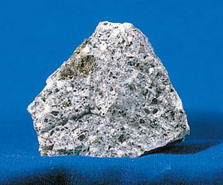
Syenite is a coarse-grained intrusive igneous rock with a general composition similar to that of granite, but deficient in quartz, which, if present at all, occurs in relatively small concentrations. It is considered a granitoid. Some syenites contain larger proportions of mafic components and smaller amounts of felsic material than most granites; those are classed as being of intermediate composition.

Kaduna State is a state in the northwest geopolitical zone of Nigeria. The state capital is its namesake, the city of Kaduna, which was the 8th largest city in the country as of 2006. Created in 1967 as North-Central State, which also encompassed the modern Katsina State, Kaduna State achieved its current borders in 1987. Kaduna State is the fourth largest and third most populous state in the country, Kaduna State is nicknamed the Centre of Learning, owing to the presence of numerous educational institutions of importance within the state such as Ahmadu Bello University.
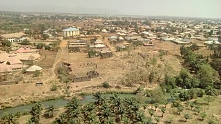
Kafanchan is a town located in the southern part of Kaduna State, Nigeria. The town owes much of its development to the railway development in the area. The railway is situated at a particular junction of the Nigerian Railway Corporation (NRC) station built in 1927. It sits on the railtrack connecting Port Harcourt, Enugu, Kafanchan, Kuru, Bauchi and finally Maiduguri. As of 2007, Kafanchan had an estimated population of 83,092.

The Nigerian National Assembly delegation from Kaduna comprises three Senators representing Kaduna Central Kaduna North, and Kaduna South, and fifteen Representatives representing Birnin-Gwari/Giwa, Lere, Zangon Kataf/Jaba, Jema'a/Sanga, Kaura, Kauru, Igabi, Chikun/Kajuru, Kachia/Kagarko, Kaduna South, Makarfi/Kudan, Ikara/Kubau, Kaduna North, Soba, Zaria Federal.
Kaduna North, often referred to as the pioneer local government, is a Local Government Area in Kaduna State, Nigeria. It is the capital of Kaduna State and its headquarters are in the town of Doka. Its postal code is 800. It has an area of 70.2 km2.
Kajuru is a local government area in southern Kaduna State, Nigeria. Its also headquarters is in the town of Kajuru. The local government is located on longitude 9° 59'N and 10° 55'N and latitude 7° 34'E and 8° 13'E, with an area of 2,229 km2.
Kaura is a town and a Local Government Area in southern Kaduna State, Nigeria. Its headquarters are in the town of Kaura in Asholyio (Moroa) Chiefdom. The Local Government Council is chaired by Matthias Siman. Other towns include: Manchok and Kagoro. It has an area of 461 km2 and a population of 174,626 at the 2006 census. The postal code of the area is 801.
Zangon Kataf is a Local Government Area in southern Kaduna State, Nigeria. Its headquarters is in the town of Zonkwa. It is also a name of a town in the chiefdom of the Atyap. Other towns include: Batadon (Madakiya), Chenkwon, Kamantan, Anchuna and Kamuru. It has an area of 2,579 km2 and a population of 318,991 at the 2006 census. The postal code of the area is 802.
Lere is a Local Government Area and town in the southern part of Kaduna State, Nigeria. Lere town is located geographically at the latitude of 10 degrees 39 North and longitude of 8 degrees 57 East. It is the headquarters of the Lere Emirate. The town and its environs have an estimated population of about 553,290 (2016). Lere Local Government has an area of 2,634 km2 and a population of 339,740 at the 2006 census. Its headquarters are in the town of Saminaka. The postal code of the area is 811.
Kauru is a Local Government Area in southern Kaduna State, Nigeria. The area is 3,186 km2. Its headquarters are in the town of Kauru. The postal code of the area is 811.
Riyom is a Local Government Area in Plateau State, Nigeria. It was carved out of the old Barkin Ladi Local Government Area on 1 October 1996 by the government of General Sani Abacha. It is headquartered in the town of Riyom to the north of the area at 9°38′00″N8°46′00″E.
The Kulu language, Ikulu, also known as Ankulu or Ikolu, is a Plateau language of Nigeria. It is spoken by the Bakulu, found in the Zangon Kataf, Kachia and Kauru Local Government Areas of Kaduna State.
Atsam, is a Kainji language of Nigeria. It is spoken by the Atsam people, mainly found in Kauru LGA of Kaduna State and Bassa LGA of Plateau State, Middle Belt, Nigeria.
Bakulu people are a people found in Zangon Kataf, Kachia and Kauru Local Government Areas of southern Kaduna State of Middle Belt, Nigeria. They speak a Plateau language called Kulu. They call their land Akulu.
Kudaru is a town in Lere Local Government Area in southern Kaduna state in the Middle Belt region of Nigeria. The postal code of the area is 811.
Moro is an East Kainji language of Nigeria belonging to the Shammo cluster.
The 2023 Nigerian presidential election in Kaduna State will be held on 25 February 2023 as part of the nationwide 2023 Nigerian presidential election to elect the president and vice president of Nigeria. Other federal elections, including elections to the House of Representatives and the Senate, will also be held on the same date while state elections will be held two weeks afterward on 11 March.
The Atsam people are found mainly in Kauru Local Government Area of Kaduna State, Middle Belt (central) Nigeria. They speak the Atsam language, an East Kainji language. Their headquarters are in the town of Damakasuwa, a few kilometres from Chawai, west of the city of Jos.
Damakasuwa is a town and headquarters of the Tsam Chiefdom of the Atsam people in Kauru Local Government Area in southern Kaduna state in the Middle Belt region of Nigeria. The postal code of the area is 811.
Chawai is a town east of the headquarters of the Tsam Chiefdom of the Atsam people in Kauru Local Government Area in southern Kaduna state in the Middle Belt region of Nigeria. The postal code of the area is 811.
