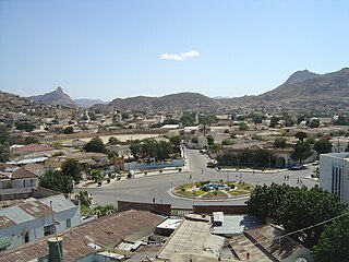
Asmara, or Asmera, is the capital and most populous city of Eritrea, in the country's Central Region. It sits at an elevation of 2,325 metres (7,628 ft), making it the sixth highest capital in the world by altitude and the second highest capital in Africa. The city is located at the tip of an escarpment that is both the northwestern edge of the Eritrean Highlands and the Great Rift Valley in neighbouring Ethiopia. In 2017, the city was declared as a UNESCO World Heritage Site for its well-preserved modernist architecture. According to local traditions, the city was founded after four separate villages unified to live together peacefully after long periods of conflict. Asmara had long been overshadowed by nearby Debarwa, the residence of the Bahr Negash or the governor of the coastal province, however it still existed as a major settlement for over half a millennium and enjoyed some importance as it stood on the trade route to Massawa. Asmara first rose to prominence during the 20th century, when it became capital of Italian Eritrea. Under Italian rule the city of Asmara experienced rapid urbanization and modernization.
Tigrinya, sometimes spelled Tigrigna, is an Ethio-Semitic language commonly spoken in Eritrea and in northern Ethiopia's Tigray Region by the Tigrinya and Tigrayan peoples respectively. It is also spoken by the global diaspora of these regions.

The Asmara-Massawa Cableway was a cableway built in Italian Eritrea before World War II.The Eritrean Ropeway, completed in 1937, ran 71.8 km from the south end of Asmara to the city-port of Massawa.
Keren, historically known as Sanhit, is the second-largest city in Eritrea. It is situated around 91 kilometres (57 mi) northwest of Asmara at an elevation of 1,590 metres (5,220 ft) above sea-level. The city sprawls on a wide basin surrounded by granitic mountains on all sides. It serves as the capital of the Anseba Region, and is home to a number of ethnic groups including the Bilen people and Tigre people.

The Northern Red Sea region, is an administrative region of Eritrea. It lies along the northern three quarters of the Red Sea, and includes the Dahlak Archipelago and the coastal city of Massawa.

The Battle of Dogali was fought on 26 January 1887 between Italy and Ethiopia in Dogali near Massawa, in present-day Eritrea.
The Tigre people are an ethnic group indigenous to Eritrea. They mainly inhabit the lowlands and northern highlands of Eritrea, with a small population in Sudan.
The main languages spoken in Eritrea are Tigrinya, Tigre, Kunama, Bilen, Nara, Saho, Afar, and Beja. The country's working languages are Tigrinya, Arabic, English, and formerly Italian.
Eritrean literature in the Tigrinya language dates, as far as is known, from the late 19th century but Ge'ez writings have been found in the 4th century BC. It was initially encouraged by European missionaries, but suffered from the general repression of Eritrean culture under Fascist rule in the 1920s and 30s. The earliest published works were primarily translations or collections of traditional poems, fables and folktales, but the renaissance of Eritrean culture promoted by the British administrators after 1942 included the appearance of the first novels in Tigrinya.

The six regions of Eritrea are divided into administrative subregions.
Articles related to Ethiopia include:
Articles related to Eritrea include:
The provinces of Eritrea existed since pre-Axumite times and became administrative provinces from Eritrea's incorporation as a colony of Italy until the conversion of the provinces into administrative regions. Many of the provinces had their own local laws since the 13th century.

Eritreans are the native inhabitants of Eritrea, as well as the global diaspora of Eritrea. Eritreans constitute several component ethnic groups, some of which are related to ethnic groups that make up the Ethiopian people in neighboring Ethiopia and people groups in other parts of the Horn of Africa. Nine of these component ethnic groups are officially recognized by the Government of Eritrea.
Ghinda subregion is a subregion in the Northern Red Sea region of Eritrea. Its capital lies at Ghinda.

Religion in Eritrea consists of a number of faiths. The two major religions in Eritrea are Christianity and Islam. However, the number of adherents of each faith is subject to debate. Estimates of the Christian share of the population range from 47% and 63%, while estimates of the Muslim share of the population range from 37% to 52%.
Eritrea, officially the State of Eritrea, is a country in the Horn of Africa region of Eastern Africa, with its capital and largest city being Asmara. It is bordered by Ethiopia in the south, Sudan in the west, and Djibouti in the southeast. The northeastern and eastern parts of Eritrea have an extensive coastline along the Red Sea. The nation has a total area of approximately 117,600 km2 (45,406 sq mi), and includes the Dahlak Archipelago and several of the Hanish Islands.
Baresa is a small town in the Northern Red Sea region of Eritrea. It lies between Asmara and Massawa, near Ghinda.
Italian Pidgin in Eritrea was a pidgin language used in Italian Eritrea when Eritrea was a colony of Italy.
The Tigrinya people, also known as the Biher-Tigrinya or Kebessa, are an ethnic group indigenous to Eritrea. They speak the Tigrinya language. There also exists a sizable Tigrinya community in the diaspora.