

Giant kelp marine forests of south east Australia is an endangered ecological community, listed under the EPBC Act of the Commonwealth of Australia. [2] The community is found in coastal waters of Victoria, South Australia, and Tasmania. [3]


Giant kelp marine forests of south east Australia is an endangered ecological community, listed under the EPBC Act of the Commonwealth of Australia. [2] The community is found in coastal waters of Victoria, South Australia, and Tasmania. [3]
Kelp forests are found in cold water regions in shallow coastal waters. Giant kelp marine forests are diverse, complex and highly productive components and foundation species of cold-water rocky marine coastlines around the world. Giant kelp marine forests in Australia are typically found in temperate south eastern waters on rocky reefs where conditions are cool and reasonably nutrient rich. [4]
The Giant kelp marine forests of south east Australia is a community extending from the ocean floor to the ocean surface, on a rocky substrate, and has a ‘forest-like’ structure with many organisms occupying its various layers, including pelagic and demersal fishes, sea birds, turtles and marine mammals in addition to the invertebrate organisms that inhabit the sea floor. [4] [5] The ecological community is characterised by a closed to semi-closed surface or subsurface canopy of M. pyrifera . This species is a foundation species which provides critical ecosystem services such as, for example, nursery grounds, primary production, and adult habitats for marine organisms, [5] including Chordata, Arthropoda, Annelida, Echinodermata, Bryozoa, Cnidaria, Mollusca, Platyhelminthes, Brachiopoda and Porifera. This is the only kelp which gives this three dimensional structure from the sea floor to the sea surface, and the loss of giant kelp plants destroys this community. [4]
Threats to the community include [4] [6]
This ecological community has been listed as endangered under the Commonwealth EPBC Act since 29 August 2012, [2] after advice to the minister. [4]
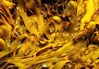
Kelps are large brown algae or seaweeds that make up the order Laminariales. There are about 30 different genera. Despite its appearance, kelp is not a plant but a stramenopile.

The benthic zone is the ecological region at the lowest level of a body of water such as an ocean, lake, or stream, including the sediment surface and some sub-surface layers. The name comes from the Ancient Greek word βένθος (bénthos), meaning "the depths". Organisms living in this zone are called benthos and include microorganisms as well as larger invertebrates, such as crustaceans and polychaetes. Organisms here generally live in close relationship with the substrate and many are permanently attached to the bottom. The benthic boundary layer, which includes the bottom layer of water and the uppermost layer of sediment directly influenced by the overlying water, is an integral part of the benthic zone, as it greatly influences the biological activity that takes place there. Examples of contact soil layers include sand bottoms, rocky outcrops, coral, and bay mud.
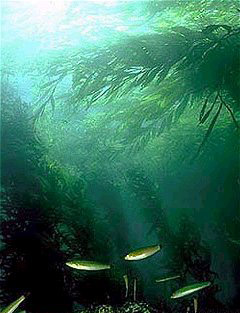
Kelp forests are underwater areas with a high density of kelp, which covers a large part of the world's coastlines. Smaller areas of anchored kelp are called kelp beds. They are recognized as one of the most productive and dynamic ecosystems on Earth. Although algal kelp forest combined with coral reefs only cover 0.1% of Earth's total surface, they account for 0.9% of global primary productivity. Kelp forests occur worldwide throughout temperate and polar coastal oceans. In 2007, kelp forests were also discovered in tropical waters near Ecuador.
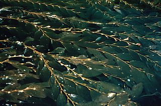
Macrocystis is a monospecific genus of kelp with all species now synonymous with Macrocystis pyrifera. It is commonly known as giant kelp or bladder kelp. This genus contains the largest of all the Phaeophyceae or brown algae. Macrocystis has pneumatocysts at the base of its blades. Sporophytes are perennial and the individual may live for up to three years; stipes/fronds within a whole individual undergo senescence, where each frond may persist for approximately 100 days. The genus is found widely in subtropical, temperate, and sub-Antarctic oceans of the Southern Hemisphere and in the northeast Pacific. Macrocystis is often a major component of temperate kelp forests.

Marine ecosystems are the largest of Earth's aquatic ecosystems and exist in waters that have a high salt content. These systems contrast with freshwater ecosystems, which have a lower salt content. Marine waters cover more than 70% of the surface of the Earth and account for more than 97% of Earth's water supply and 90% of habitable space on Earth. Seawater has an average salinity of 35 parts per thousand of water. Actual salinity varies among different marine ecosystems. Marine ecosystems can be divided into many zones depending upon water depth and shoreline features. The oceanic zone is the vast open part of the ocean where animals such as whales, sharks, and tuna live. The benthic zone consists of substrates below water where many invertebrates live. The intertidal zone is the area between high and low tides. Other near-shore (neritic) zones can include mudflats, seagrass meadows, mangroves, rocky intertidal systems, salt marshes, coral reefs, lagoons. In the deep water, hydrothermal vents may occur where chemosynthetic sulfur bacteria form the base of the food web.
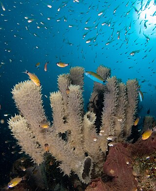
A marine habitat is a habitat that supports marine life. Marine life depends in some way on the saltwater that is in the sea. A habitat is an ecological or environmental area inhabited by one or more living species. The marine environment supports many kinds of these habitats.
Cape Byron Marine Park is one of four marine parks in New South Wales, Australia, and is the most recently sanctioned. The Cape Byron Marine Park is located in Northern NSW and extends 37 kilometres (23 mi) from the Brunswick River to Lennox Head. The marine park extends out to 3 nautical miles which dictates the border between state and federal jurisdiction. The marine park covers an area of 220 square kilometres (85 sq mi) and includes a variety of marine terrain including beaches, rocky shores, open ocean and the tidal waters of the Brunswick River and its tributaries, the Belongil Creek and Tallow Creek. The Cape Byron Marine Park was declared in 2002 and the zoning plan was implemented in April 2006. Of the 15 distinct marine ecosystems identified within the Tweed-Moreton bioregion, the Cape Byron Marine Park supports 10 of these.

The Great Southern Reef is a system of interconnected reefs that spans the southern coast of continental Australia and Tasmania and extends as far north as Brisbane to the east and Kalbarri to the west. It covers 71,000 km2 (27,000 sq mi) of ocean and straddles five states, running along the coast for 8,000 km (5,000 mi).
The Betty's Bay Marine Protected Area is part of the Kogelberg Biosphere Reserve. It is about 29km south-east of Gordon's Bay and approximately 37km north-west of Hermanus on the south-western coast of the Western Cape. It is in the Atlantic Ocean immediately adjacent to the town of Betty's Bay, in the Overstrand Municipal area.

The De Hoop Marine Protected Area lies between Arniston and the mouth of the Breede River on the south coast of South Africa adjacent to the De Hoop Nature Reserve. The MPA is 51 kilometres long, and extends 5 nautical miles to sea. The whole MPA is a restricted area and is part of the migratory route and calving area for Southern right whales. The area protects habitats for several economically important inshore reef fish species, and ensures the retention of marine biomass in this part of the coast. The limestone coastline is includes archaeological sites and middens that date back centuries. The MPA is close to the Breede River estuary and, provides protection for species like cob that breed in the estuary and then return to the ocean.
The Helderberg Marine Protected Area is a small marine conservation area on the north-eastern side of False Bay in the Western Cape province of South Africa, It lies between the mouths of the Lourens River in the Strand, and the Eerste River in Macassar.
The Hluleka Marine Protected Area is an inshore conservation region in the territorial waters of the Eastern Cape province of South Africa.
The Jutten Island Marine Protected Area is an inshore conservation region in the territorial waters of South Africa in Saldanha Bay, in the Western Cape.
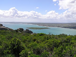
The Langebaan Lagoon Marine Protected Area is an inshore conservation region in the territorial waters of South Africa.
The Stilbaai Marine Protected Area is an inshore conservation region in the territorial waters near Stilbaai on the south coast of the Western Cape province of South Africa.
The Sardinia Bay Marine Protected Area is an inshore conservation region in the territorial waters of the Eastern Cape province, South Africa
The poleward migration of coral species refers to the phenomenon brought on by rising sea temperatures, wherein corals are colonising cooler climates in an attempt to circumvent coral bleaching, rising sea levels and ocean acidification. In the age of Anthropocene, the changing global climate has disrupted fundamental natural processes and brought about observable changes in the submarine sphere. Whilst coral reefs are bleaching in tropical areas like the Great Barrier Reef, even more striking, and perhaps more alarming; is the growth of tropical coral species in temperate regions, which has taken place over the past decade. Coral reefs are frequently compared to the "canaries in the coal mine," who were used by miners as an indicator of air quality. In much the same way, "coral reefs are sensitive to environmental changes that could damage other habitats in the future," meaning they will be the first to visually exhibit the true implications of global warming on the natural world.
The Marcus Island Marine Protected Area is a inshore conservation region in the territorial waters of South Africa
The Sixteen Mile Beach Marine Protected Area is a coastal conservation region in the territorial waters of South Africa, near Saldanha Bay on the Western Cape coast. The MPA is part of the West Coast National Park which is the core component of the Cape West Coast Biosphere Reserve. The beach stretches from Yzerfontein's Main Beach to the start of the West Coast National Park.
The Trafalgar Marine Protected Area is an inshore conservation region in the territorial waters of South Africa in kwaZulu-Natal, between Port Edward and Margate.
{{citation}}: CS1 maint: multiple names: authors list (link)