Related Research Articles

Johnson County is a county located in the U.S. state of Arkansas. As of the 2020 census, the population was 25,749. The county seat is Clarksville. Johnson County is Arkansas's 30th county, formed on November 16, 1833, from a portion of Pope County and named for Benjamin Johnson, a Territorial Judge. It is an alcohol prohibition or dry county.

Emerson is a city in Mills County, Iowa, United States. The population was 403 at the time of the 2020 census.

Gustin Township is a civil township of Alcona County in the U.S. state of Michigan. The population was 773 at the 2020 census.

Casco Township is a civil township of St. Clair County in the U.S. state of Michigan. As of the 2020 Census, the township population was 3,990.

The Mulberry River is a 70-mile-long (110 km) tributary of the Arkansas River in northwestern Arkansas in the United States. Via the Arkansas River, it is part of the watershed of the Mississippi River. It has been designated a National Wild and Scenic River. The drainage basin of the Mulberry River has an area of 373 square miles (970 km2) and the annual average mean flow of the river near its mouth is 557 cubic feet per second.

School District #160 is a consolidated public school district located predominantly in Lancaster County but also extending into Gage County, Nebraska, United States. It serves a number of small communities including Roca, Hickman, Firth, Cortland, Panama, Princeton, Holland, Cheney, and Rokeby. The school district was founded on June 1, 1964, and was named in honor of Senator George William Norris, who represented the state of Nebraska in the United States Senate from 1913 to 1943. The school district currently enrolls just under 2000 students in grades K-12.
The Canton of Rennes-Sud-Est is a former canton of France, in the Ille-et-Vilaine département. It had 37,247 inhabitants (2012). It was disbanded following the French canton reorganisation which came into effect in March 2015.

New Blaine is an unincorporated community and census-designated place (CDP) in Logan County, Arkansas, United States. Per the 2020 census, the population was 173.
Durham is an unincorporated community in eastern Washington County, Arkansas, United States. The community is on Arkansas Highway 16 along the White River valley between Elkins to the northwest and Thompson in Madison County to the southeast. Its elevation is 1,247 feet (380 m).
Alabam is an unincorporated community in Madison County, Arkansas, United States. The community is located on Arkansas Highway 127, approximately six miles northeast of Huntsville. The community of Old Alabam is about one mile south at the intersection of Highway 127 and U.S. Route 412. Alabam is on a broad ridge between War Eagle Creek to the southwest and the Kings River to the northeast.
Coin is an unincorporated community in eastern Carroll County, Arkansas, United States.
Rule is an unincorporated community in Carroll County, Arkansas, United States. The community is located on Arkansas Highway 103 on the banks of Osage Creek and about four miles south of Green Forest.
Deer Creek is a stream in northwestern Benton County, Arkansas and southwestern McDonald County, Missouri. It is a tributary of Butler Creek.
Barren Creek is a stream in Polk County in the U.S. state of Missouri. It is a tributary of Bear Creek.
Health is an unincorporated community in Madison County, Arkansas, United States. The community is located on a high ridge of the Boston Mountains in the southwestern corner of Madison County at an elevation of 2,411 feet (735 m).
Denver is a community in Carroll County in northwest Arkansas, United States. Denver is located on the east bank of Long Creek near the confluence of Dry Creek with Long Creek and approximately one mile west of the Carroll-Boone county line. The community is accessed by county road from Arkansas Highway 396, which passes about 1.5 miles to the north. Farewell is about three miles to the west.
Farewell is a community in Carroll County in northwest Arkansas, United States. The community is on Arkansas Highway 311, northeast of Green Forest. The community of Denver lies on the banks of Long Creek approximately three miles to the east. The community of Yocum is three miles northwest on Arkansas Highway 103.
Boston is an unincorporated community in the Boston Mountains of southeastern Madison County, Arkansas, United States. The community is located on Arkansas Highway 16 between Pettigrew to the southwest and Red Star to the northeast. The community is on a high ridge at an elevation of 2,329 feet (710 m). The location is at the headwaters of four streams: Kings River to the northeast, War Eagle Creek to the northwest, the White River to the east and southwest and Little Mulberry Creek to the southeast.
Webb City is an unincorporated community in Franklin County, in the U.S. state of Arkansas.
Hurricane Creek is a tributary to the Big Piney Creek, a river in Ozark-St. Francis National Forest in the state of Arkansas, which is a tributary of the Arkansas River and which is, in turn, part of the Mississippi River System. It is managed by the United States Forest Service and categorized as one of the Wild and Scenic Rivers of the United States.
References
- ↑ U.S. Geological Survey Geographic Names Information System: Gillian Settlement, Arkansas
- ↑ Arkansas Atlas & Gazetteer, DeLorme, 2004, 2nd edition, p. 32, ISBN 0-89933-345-1
Municipalities and communities of Johnson County, Arkansas, United States | ||
|---|---|---|
| Cities | 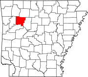 | |
| Town | ||
| CDPs | ||
| Other unincorporated communities | ||
| | This article about a location in Johnson County, Arkansas is a stub. You can help Wikipedia by expanding it. |