Lamar, Arkansas

Last updated
Lamar, Arkansas
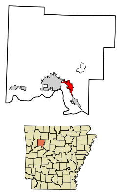
Johnson County Arkansas Incorporated and Unincorporated areas Lamar Highlighted 0538290.svg
Location of Lamar in Johnson County, Arkansas
Coordinates: 35°26′37″N93°23′42″W / 35.44361°N 93.39500°W / 35.44361; -93.39500 Coordinates: 35°26′37″N93°23′42″W / 35.44361°N 93.39500°W / 35.44361; -93.39500
Country United States
State Arkansas
County Johnson
Area
[1]
  Total4.64 sq mi (12.03 km2)
  Land4.62 sq mi (11.95 km2)
  Water0.03 sq mi (0.07 km2)
Elevation
[2]
430 ft (130 m)
Population
 (2020)
  Total1,719
  Density372.40/sq mi (143.80/km2)
Time zone UTC-6 (Central (CST))
  Summer (DST) UTC-5 (CDT)
ZIP code
72846
Area code 479
FIPS code 05-38290
GNIS feature ID2404879 [2]

Lamar is a city in Johnson County, Arkansas, United States. The population was 1,605 at the 2010 census, [3] up from 1,415 at the 2000 census.

Contents

Geography

Lamar is located in southeastern Johnson County in the valley of Cabin Creek. U.S. Route 64 is Lamar's Main Street and leads northwest 5 miles (8 km) to Clarksville, the county seat, and south 4 miles (6 km) to Knoxville. Interstate 40 crosses US 64 2 miles (3 km) south of Lamar at Exit 64 and leads west 64 miles (103 km) to Fort Smith and southeast 19 miles (31 km) to Russellville. Little Rock is 95 miles (153 km) southeast of Lamar via I-40.

According to the United States Census Bureau, Lamar has a total area of 4.7 square miles (12.3 km2), of which 0.02 square miles (0.05 km2), or 0.38%, are water. [3]

Demographics

Historical population
CensusPop.Note
1900 474
1910 5209.7%
1920 5424.2%
1930 449−17.2%
1940 4745.6%
1950 55517.1%
1960 514−7.4%
1970 58914.6%
1980 70820.2%
1990 7688.5%
2000 1,41584.2%
2010 1,60513.4%
2020 1,7197.1%
U.S. Decennial Census [4]

2020 census

Lamar racial composition [5]
RaceNumberPercentage
White (non-Hispanic)1,40181.5%
Black or African American (non-Hispanic)281.63%
Native American 221.28%
Asian 90.52%
Other/Mixed 915.29%
Hispanic or Latino 1689.77%

As of the 2020 United States census, there were 1,719 people, 747 households, and 486 families residing in the city.

2000 census

As of the census [6] of 2000, there were 1,415 people, 529 households, and 362 families residing in the city. The population density was 324.9 inhabitants per square mile (125.4/km2). There were 585 housing units at an average density of 134.3 per square mile (51.9/km2). The racial makeup of the city was 95.97% White, 0.14% Black or African American, 1.13% Native American, 0.21% Asian, 0.64% from other races, and 1.91% from two or more races. 3.46% of the population were Hispanic or Latino of any race.

There were 529 households, out of which 35.5% had children under the age of 18 living with them, 51.6% were married couples living together, 12.1% had a female householder with no husband present, and 31.4% were non-families. 28.0% of all households were made up of individuals, and 11.9% had someone living alone who was 65 years of age or older. The average household size was 2.54 and the average family size was 3.05.

In the city, the population was spread out, with 25.8% under the age of 18, 9.6% from 18 to 24, 27.4% from 25 to 44, 21.5% from 45 to 64, and 15.7% who were 65 years of age or older. The median age was 36 years. For every 100 females, there were 92.3 males. For every 100 females age 18 and over, there were 92.0 males.

The median income for a household in the city was $23,317, and the median income for a family was $27,143. Males had a median income of $23,309 versus $16,207 for females. The per capita income for the city was $11,852. About 14.8% of families and 17.7% of the population were below the poverty line, including 18.7% of those under age 18 and 15.2% of those age 65 or over.
Education

Public education for early childhood, elementary and secondary students is primarily provided by the Lamar School District, which includes:

Notable people

Lee Cazort, the youngest ever Speaker of the Arkansas House of Representatives and youngest ever Lieutenant Governor of Arkansas, attended public school in Lamar before moving to Fort Smith.

Related Research Articles

<span class="mw-page-title-main">Johnson County, Arkansas</span> County in Arkansas, United States

Johnson County is a county located in the U.S. state of Arkansas. As of the 2020 census, the population was 25,749. The county seat is Clarksville. Johnson County is Arkansas's 30th county, formed on November 16, 1833, from a portion of Pope County and named for Benjamin Johnson, a Territorial Judge. It is an alcohol prohibition or dry county.

<span class="mw-page-title-main">Fulton County, Arkansas</span> County in Arkansas, United States

Fulton County is a county located in the U.S. state of Arkansas. As of the 2020 census, the population was 12,075. The county seat is Salem. Fulton County was formed on December 21, 1842, and named for William Fulton, the last governor of the Arkansas Territory. It is an alcohol prohibition or dry county.

<span class="mw-page-title-main">Monticello, Arkansas</span> City in Arkansas, United States

Monticello is a college town in, and the county seat of, Drew County, Arkansas, United States. As of the 2010 census it had a population of 9,467. Founded in 1849 in the Arkansas Timberlands near the Arkansas Delta region, the city has long been a commercial, cultural and educational hub for southeast Arkansas. With a historically agriculture- and silviculture-based economy, Monticello has diversified to include growth from the medical sector and the University of Arkansas at Monticello (UAM).

<span class="mw-page-title-main">Charleston, Arkansas</span> City in Arkansas, United States

Charleston is a city in Franklin County, Arkansas, United States, and along with Ozark is one of the two county seats of Franklin County. It is part of the Fort Smith, Arkansas-Oklahoma Metropolitan Statistical Area. The population was 2,494 at the 2010 census, down from 2,965 in 2000.

<span class="mw-page-title-main">Calico Rock, Arkansas</span> City in Arkansas, United States

Calico Rock is a city in Izard County, Arkansas, United States. The population was 1,545 at the 2010 census, up from 991 in 2000.

<span class="mw-page-title-main">Melbourne, Arkansas</span> City in Arkansas, United States

Melbourne is a city and county seat of Izard County, Arkansas, United States. The population was 1,848 at the 2010 census. It is home to the main campus of Ozarka College.

<span class="mw-page-title-main">Scranton, Arkansas</span> City in Arkansas, United States

Scranton is a city in Logan County, Arkansas, United States. The population was 224 at the 2010 census. It was named after Scranton, Pennsylvania.

<span class="mw-page-title-main">Austin, Arkansas</span> City in Arkansas, United States

Austin is a city in Lonoke County, Arkansas, United States. The population was 2,038 as of the 2010 census and an estimated 3,693 as of 2018. It is part of the Little Rock–North Little Rock–Conway Metropolitan Statistical Area.

<span class="mw-page-title-main">London, Arkansas</span> City in Arkansas, United States

London is a city in Pope County, Arkansas, United States. The population was 1,039 at the 2010 census. It is part of the Russellville Micropolitan Statistical Area.

<span class="mw-page-title-main">East End, Arkansas</span> CDP in Arkansas, United States

East End is a census-designated place (CDP) in Saline County, Arkansas, United States. The population was 6,998 at the 2010 census. It is part of the Little Rock–North Little Rock–Conway Metropolitan Statistical Area.

<span class="mw-page-title-main">Mansfield, Arkansas</span> City in Arkansas, United States

Mansfield is a city in Scott and Sebastian counties Arkansas, United States. The Sebastian County portion of the city is part of the Fort Smith, Arkansas-Oklahoma Metropolitan Statistical Area. As of the 2010 Census, the population was 1,139. The population was 1,097 at the 2000 census.

<span class="mw-page-title-main">Lavaca, Arkansas</span> City in Arkansas, United States

Lavaca is a city in Sebastian County, Arkansas, United States. It is part of the Fort Smith, Arkansas-Oklahoma Metropolitan Statistical Area. As of the 2010 Census the population was 2,289. Lavaca was incorporated in 1919.

<span class="mw-page-title-main">Horatio, Arkansas</span> City in Arkansas, United States

Horatio is a city in Sevier County, Arkansas, United States. The population was 1,044 at the 2010 census.

<span class="mw-page-title-main">Junction City, Arkansas</span> City in Arkansas, United States

Junction City is a city in Union County, Arkansas, United States, and is the twin city of neighboring Junction City, Louisiana. The population was 581 at the 2010 census.

<span class="mw-page-title-main">Cotton Plant, Arkansas</span> City in Arkansas, United States

Cotton Plant is a city in southern Woodruff County, Arkansas, United States. As of the 2020 census, the city had a total population of 529.

<span class="mw-page-title-main">New Liberty, Iowa</span> City in Iowa, USA

New Liberty is a city in Scott County, Iowa, United States. The population was 138 at the time of the 2020 census.

<span class="mw-page-title-main">Lamar, Missouri</span> City in Missouri, United States

Lamar is a city in and the county seat of Barton County, Missouri, United States. As of the 2020 census, the city population was 4,266. It is known as the birthplace of Harry S. Truman, the 33rd president of the United States.

<span class="mw-page-title-main">West Hattiesburg, Mississippi</span> Census-designated place in Mississippi, United States

West Hattiesburg is an unincorporated area and census-designated place (CDP) in Lamar County, Mississippi, west of the city of Hattiesburg and east of the community of Oak Grove. It is part of the Hattiesburg metropolitan area. It had a decline in population from 6,305 at the 2000 census to 5,909 at the 2010 census.

<span class="mw-page-title-main">Beasley, Texas</span> City in Texas, United States

Beasley is a city in Fort Bend County, Texas, United States, within the Houston–Sugar Land metropolitan area. The city's population was 641 at the 2010 census, up from 590 at the 2000 census. State Highway Loop 540 goes straight through the city from the northeast to the southwest while U.S. Route 59, the Southwest Freeway, passes to the south of Beasley. The Union Pacific Railroad tracks run parallel with Loop 540.

<span class="mw-page-title-main">Sun Valley, Texas</span> City in Texas, United States

Sun Valley is a small city in Lamar County, Texas, United States. The population was 69 at the 2010 census, up from 51 at the 2000 census; in 2020, its population was 70.

References

  1. "2020 U.S. Gazetteer Files". United States Census Bureau. Retrieved October 29, 2021.
  2. 1 2 U.S. Geological Survey Geographic Names Information System: Lamar, Arkansas
  3. 1 2 "Geographic Identifiers: 2010 Census Summary File 1 (G001): Lamar city, Arkansas". American Factfinder. U.S. Census Bureau. Archived from the original on February 13, 2020. Retrieved April 24, 2018.
  4. "Census of Population and Housing". Census.gov. Retrieved June 4, 2015.
  5. "Explore Census Data". data.census.gov. Retrieved 2022-01-01.
  6. "U.S. Census website". United States Census Bureau . Retrieved 2008-01-31.