Tunas Creek formerly known as Arroyo Escondido, is a Stream tributary to the Pecos River, in Pecos County, Texas. Its source is at 30°52′53″N102°34′59″W on the southwestern side of Big Mesa.
Dragoon Wash, a stream tributary to the San Pedro River, in Cochise County, Arizona. It has its source just southwest of the town of Dragoon. 32°01′21″N110°02′46″W It runs southwesterly to meet the San Pedro River.
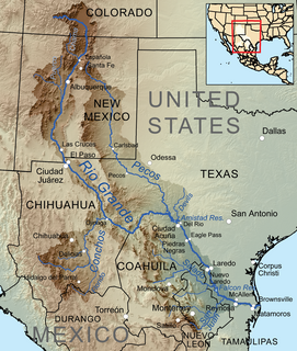
The First Crossing of Devils River was the first point at which the Devils River was crossed by the San Antonio-El Paso Road. It was located 10.22 miles west of San Felipe Springs at the mouth of San Pedro Creek on the Devils River. It was 2.54 miles southeast of Painted Caves, on California Creek, a noted camp location on the road. The crossing point and the gorge leading down to it from the east are now submerged under Lake Amistad.
Turkey Creek, a tributary of the Nueces River with its source in Kinney County, Texas 29°14′32″N100°06′56″W. It passes through Uvalde and Dimmit Counties to its mouth at Espantosa Lake in Espantosa Slough south of Crystal City in Zavala County, Texas.
Pinto Creek, formerly known as Piedra Pinto Creek, a tributary to the Rio Grande in Kinney County, Texas. It has its source, at 29°30′53″N100°24′13″W.
Mud Creek, originally known as Maverick Creek, a stream in Kinney County, Texas tributary to Sycamore Creek and the Rio Grande. It has its source at 29°28′10″N100°36′24″W.
California Creek, formerly Painted Cave Spring Creek a stream in Val Verde County, Texas, formerly a tributary of Devils River it now flows into the north side of Amistad Reservoir at an elevation of 1119 feet. California Creek has its source at 29°37′29″N101°02′14″W.
Painted Caves was a cave containing a spring in Val Verde County, Texas, 20 kilometers southeast of Comstock, Texas. The cave accompanied a camp site along the San Antonio-El Paso Road on Painted Cave Spring Creek and was named for the indigenous cave paintings found inside. It was located 2.54 miles northwest of the First Crossing of Devils River and 15.73 miles southeast of California Spring. The cave is now submerged under Lake Amistad.
Howard Springs, was a historical spring, located in the stream channel of Howard Draw at an elevation of 2031 feet, just north of the mouth of Government Canyon at its confluence with Howard Draw in what is now Crockett County, Texas.
Live Oak Creek, a stream with its source in Reagan County, Texas at 31°10′45″N101°42′01″W at an elevation of 2938 feet, that runs southward to its mouth at an elevation of 2001 feet on the Pecos River in Crockett County, Texas.
Head of Devil's River, a place on the Devils River where it has its confluence with Pecos Canyon at an elevation of 1722 feet, below Beaver Lake, nineteen and a half miles above the second crossing of Devils River. Here the San Antonio-El Paso Road left the Devils River to go northwest, 44 miles across Johnson Draw, Government Canyon and Howard Draw to Howard Springs, then 30.44 miles on to Live Oak Creek and Fort Lancaster, 3 miles further near the Pecos River.
Pecos Spring is a spring, 1.1 miles (3 km) northeast of Sheffield, in Pecos County, Texas. It lies at an elevation of 2060 feet. Pecos Spring was emitted from the Edwards and associated limestones of the Edwards-Trinity (Plateau) aquifer. On March 7, 1924, it discharged 0.7 cubic feet per second but by August 17, 1943, that had been reduced to 0.5 cubic feet per second. By 1961, its flow had ceased.
Cow Springs Ranch is a locale, located in Luna County, New Mexico. The ranch headquarters is located at Cow Springs, originally Ojo de Vaca.
Burro Cienega, a stream that arises at an elevation of 5990 feet, at 32°28′48″N108°27′05″W, in the Big Burro Mountains, in Grant County and whose mouth is at 4196 feet at a playa about 5.5 miles southeast of Lordsburg in Hidalgo County, New Mexico.
Beaver Lake was a small lake or beaver pond formerly found on the Devils River in what is now Val Verde County, Texas. It was located about 19 miles north of second crossing of Devil's River and 44 miles from Howard Springs.
Tunas Spring, formerly Escondido Spring, a spring along Tunas Creek, a tributary of the Pecos River in Pecos County, Texas.
Leaving of Pecos was originally a camping place along the west bank of the Pecos River, on the wagon road called the Lower Emigrant Road, Military Road or San Antonio-El Paso Road in Texas. It was located 38 miles north of the Lancaster Crossing of the Pecos, and 16 miles east of the first crossing of Escondido Creek. It was also located a mile north of where the wagon road had its junction with a cutoff to the north to the wagon road called the Upper Emigrant Road between Fredricksburg, Texas and Comanche Springs, now Fort Stockton, Texas, where it joined the Lower Emigrant Road. It was later a stopping place on the route of San Antonio - El Paso Mail and the San Antonio-San Diego Mail Line.
Point of Rocks also known as Bald Rock, is a hill and a locale in Jeff Davis County, Texas. Point of Rocks, is an isolated hill with a spring once known as Bald Rock Spring. It was used as a watering place and campsite on the San Antonio-El Paso Road, 10 miles west of Fort Davis, Texas, now Point of Rocks Roadside Park. The elevation of Point of Rocks Spring, is at 5,469 feet / 1,667 meters, at the foot of the southeast slope of the Point of Rocks that reaches over 5,920 feet along its crest.
Limpia Creek, originally known as the Rio Limpia, is a stream that heads in Jeff Davis County, Texas and its mouth is in Pecos County, Texas. Limpa is the Spanish word for "clear or clean water". The creek has its head in the Davis Mountains at an elevation of 7,160 feet, at location 30°38′27″N104°09′42″W on the northeast slope of Mount Livermore. The creek flows 42 miles down Limpia Canyon past Fort Davis and Wild Rose Pass to the canyon mouth, where it turns eastward to its mouth at its confluence with Barrilla Draw, where it disappears into the ground at an elevation of 3,533 feet / 1,077 meters.