Mid Wales is the central region of Wales. The Mid Wales Regional Committee of the National Assembly for Wales covered the unitary authority areas of Ceredigion and Powys and the area of Gwynedd that had previously been the district of Meirionydd. A similar definition is used by the BBC. The Wales Spatial Plan defines a region known as "Central Wales" which covers Ceredigion and Powys. If Mid Wales is classed as Ceredigion and Powys, the area would be 6,962 square kilometres (2,688 sq mi).
Cefnllys was a medieval town in Radnorshire in central Wales. Only St Michael's Church remains standing, with mounds indicating the remains of other buildings existing before the decline of the town in the 19th century. Close by on the hill known as Castle Rock are the remains of what is known as Cefnllys Castle. Almost encircling the hill, church and remains of the town is the River Ithon which continues to Llandrindod Wells a little over a mile away.

Sycharth is a motte and bailey castle and town in Llansilin, Powys, Wales. Until 1996 Sycharth was in the historic county of Denbighshire, but was then transferred to the Shire area of Montgomeryshire within Powys. Sycharth Castle was the birthplace of Owain Glyndŵr.

Llangynog is a village and community which lies at the confluence of the Afon Eirth and the Afon Tanat at the foot of the Berwyn range in north Powys, Wales.
Pilleth is a small village south of Knighton in Powys, Wales. It is the site of the ancient church and holy well of St. Mary’s which stands on Bryn Glas Hill overlooking the River Lugg, as it makes its way to Presteigne.

The Caersws Roman Forts are two Roman military camps at Caersws, Powys in Mid Wales. They were garrisoned during the occupation of Great Britain between the 1st and 5th centuries when this part of Wales was part of the Roman province of Britannia Superior. A surviving section of Roman Road lies to the west of the encampments.

Breidden Hill is an extinct volcanic hill in Powys, Wales, near the town of Welshpool. It is immediately surrounded by the villages of Trewern, Criggion, Crew Green and Llandrinio. The peak of the hill reaches to 367 metres (1,204 ft). Footpaths which lead up to the summit provide excellent 360 degree views over Powys and over the border with England to the Shropshire Plain.

Sheldon Stone Circle is a prehistoric stone circle, located at grid reference NJ822249, to the south-east of Oldmeldrum, Aberdeenshire, Scotland.

The A490 is a road in the United Kingdom running from Churchstoke, Powys to Llanfyllin, also in Powys. The road runs for a short distance through Shropshire in England.

Long Mountain is a hill located east of Welshpool in Powys, Wales. It crosses the national boundaries of England and Wales, and also the county boundaries of Powys and Shropshire.

Moel y Gaer is an Iron Age hillfort located on a summit at the southern end of Halkyn Mountain, overlooking the village of Rhosesmor, Flintshire, Wales. It is a well-preserved hillfort overlooking the Dee Estuary. Excavations in the early 1970s revealed a sequence of defensive structures made of timber and several phases of building work inside the ramparts.

Moel Tŷ Uchaf is a stone circle near the village of Llandrillo, Denbighshire, North Wales. It is a collection of 41 stones with a Cist in the centre and an outlying stone to the north-north-east. The circle is 12 metres in diameter.
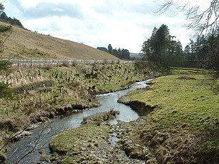
The River Ithon is a major left-bank tributary of the River Wye in Powys, mid Wales. It rises in the broad saddle between the western end of Kerry Hill and the hill of Glog to its west and flows initially southwards to Llanbadarn Fynydd. It then takes a twisting route south via the villages of Llanbister, Llanddewi Ystradenni and Penybont before turning southwest, then doubling back northwards towards Crossgates. From here it resumes a southwesterly course, flowing past Llandrindod Wells to a confluence with the Wye, 1 mile to the south of Newbridge-on-Wye.

Powys is the largest administrative county in Wales. With over a quarter of Wales's land area, covering much of the eastern half of the country, it is a county of remote uplands, low population and no coastline. It was created in more or less its current form in 1974, and is the only one of the large county units created at that time to have been carried forward intact at the 1996 local government re-organisation. It comprises three historic counties, namely Montgomeryshire, Radnorshire, and most of Brecknockshire. There are 950 Scheduled monuments within the county. This is far more than can be sensibly covered in one list, so each of the 3 historic counties is therefore listed separately, and each of these has two lists - one for the prehistoric sites and one for the Roman, medieval and post-medieval sites.
Eisteddfa Gurig is a hamlet located in Ceredigion on its border with Powys and situated along the A44. Its name comes from the Welsh word eisteddfa, meaning seat and the name of St Curig. This gives the meaning of Curig's seat. It is said that Curig rested on the hill here and looked down into the Wye Valley. He decided to build a church in the valley, which is still there today in the village of Llangurig.

St Nicholas's Church, formerly called St Mary's Church until 1881, is a Church of England parish church in Church Stoke, Powys, Wales. The church's current building is largely the result of 19th-century reconstruction, but it retains its 13th-century tower with a later timber belfry. From the period prior to the 19th century, only a font, a stoup and a chest have survived up to three phases of restoration and reconstruction. The main body of the church with its large high pitched roof dates to the second half of the 19th century. It is a Grade II listed building.

Glantwymyn is a community in the northwest (Montgomeryshire) of Powys, Wales.

Painscastle is a village and community in Powys, Wales and also a village which takes its name from the castle. It lies between Builth and Hay-on-Wye, approximately 3 miles from the Wales-England border today.


