
Visconte Maggiolo, also spelled Maiollo and Maiolo, was a Genoese cartographer.
Angelino Dulcert, probably the same person known as Angelino de Dalorto, and whose real name was probably Angelino de Dulceto or Dulceti or possibly Angelí Dolcet, was an Italian-Majorcan cartographer.

Paolo Emilio Taviani was an Italian political leader, economist, and historian of the career of Christopher Columbus. He was a partisan leader in Liguria, a Gold Medal of the Italian resistance movement, then a member of the Consulta and the Constituent Council, later of the Italian Parliament from 1948 until his death. Several times minister in the Republic’s governments. He was author of studies on economics and important works on Christopher Columbus, University professor and journalist.
Gianni Baget Bozzo was an Italian Catholic priest and politician.

Guglielmo della Porta was an Italian architect and sculptor of the late Renaissance or Mannerist period.

"Majorcan cartographic school" is the term coined by historians to refer to the collection of predominantly Jewish cartographers, cosmographers and navigational instrument-makers and some Christian associates that flourished in Majorca in the 13th, 14th and 15th centuries until the expulsion of the Jews. The label is usually inclusive of those who worked in Catalonia. The Majorcan school is frequently contrasted with the contemporary Italian cartography school.

The Delle Piane family is an old Genoese noble family first recorded in Polcevera in 1121. Over the past ten centuries it has produced many distinguished government officials, clerics, diplomats, soldiers and patrons.

The Palazzo Brignole Sale or Palazzo Rosso is a house museum located in Via Garibaldi, in the historical center of Genoa, in Northwestern Italy. The palace is part of the UNESCO World Heritage Site Genoa: Le Strade Nuove and the system of the Palazzi dei Rolli. The rich art collection inside, along with the galleries of Palazzo Bianco and Palazzo Doria Tursi, is part of the Musei di Strada Nuova and consists of the works of artists of the caliber of Antoon van Dyck, Guido Reni, Paolo Veronese, Guercino, Gregorio De Ferrari, Albrecht Dürer, Bernardo Strozzi and Mattia Preti.
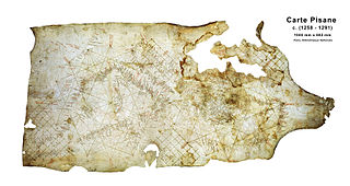
The Carta Pisana or Carte Pisane is a map probably made at the end of the 13th century, about 1275–1300, currently conserved in the Département des cartes et plans at the Bibliothèque nationale de France. New research suggests that it was made a century later. It was found in Pisa, hence its name. It shows the whole Mediterranean, the Black Sea and a part of the Atlantic coast, from the north of present-day Morocco to the present-day Netherlands, but the accuracy of the map is mostly limited to the Mediterranean. It is the oldest surviving nautical chart. It is a portolan chart, showing a detailed survey of the coasts, and many ports, but bears no indication on the topography or toponymy of the inland. On the map, North is on the top, in contrast to other maps of the same period such as the Hereford Mappa Mundi, where East is on the top.
Domenico and Francesco Pizzigano, known as the Pizzigani brothers, were 14th-century Venetian cartographers. Their surname is sometimes given as Pizigano in older sources.
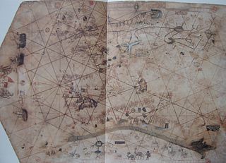
The Weimar map is an anonymous 15th-century Italian portolan chart, held by the Grand Ducal Library of Weimar. Although frequently dated as 1424, most historians believe it was probably composed a half century later. The author is unknown, although said to be a member of the Freducci family of cartographers of Ancona, most probably Conte di Ottomano Freducci. Faint and fragile, the Weimar map is rarely photographed and has been hard to decipher.
Battista Beccario, also known as Baptista Beccharius, was a 15th-century Genoese cartographer.

The Palazzo Angelo Giovanni Spinola is a palace located in Via Garibaldi, in the historical center of Genoa, in Northwestern Italy. It was one of the 163 Palazzi dei Rolli of Genoa, the selected private residences where the notable guests of the Republic of Genoa were hosted during State visits. On 13 luglio del 2006 it was included in the list of 42 palaces which now form the UNESCO World Heritage Site Genoa: Le Strade Nuove and the system of the Palazzi dei Rolli. Now owned by a bank, it is possible to visit the areas open to the public.

The Palazzo Doria or Palazzo Andrea e Gio. Batta Spinola is a palace located in Via Garibaldi, in the historical center of Genoa, in Northwestern Italy. It was one of the 163 Palazzi dei Rolli of Genoa, the selected private residences where the notable guests of the Republic of Genoa were hosted during State visits. On 13 luglio del 2006 it was included in the list of 42 palaces which now form the UNESCO World Heritage Site Genoa: Le Strade Nuove and the system of the Palazzi dei Rolli.

Conrad Malaspina, also known as L'Antico or The Old, was an Italian nobleman who lived in the 12th century. There is no certainty about Conrad's birthdate but most historians agree that it is around 1180, his death date is also uncertain but it is speculated to be around July 1254. Conrad was the forefather of the "Spino Secco" branch of the Malaspina family. Conrad Malaspina's achievements were of fundamental importance for the way Italian territories were shaped. He had very close relationships with Emperor Frederick II as well as many intellectuals and political figures of the time.
The Palazzo Doria-Spinola or Palazzo Antonio Doria is a palace located in largo Eros Lanfranco in the historical center of Genoa, Northwestern Italy. The palace was one of the 163 Palazzi dei Rolli of Genoa, one of those selected private residences where notable guests of the Republic of Genoa were hosted during State visits. On 13 luglio del 2006 it was added to the list of 42 palaces which now form the UNESCO World Heritage Site Genoa: Le Strade Nuove and the system of the Palazzi dei Rolli. The palace now hosts the Prefecture of Genoa and the seat of the Province of Genoa. It is possible to visit the areas of the building which are open to the public.

The Villa Croce Museum of Contemporary Art is a permanent collection of Italian and international contemporary art hosted in a villa in the Carignano quarter of Genoa, northwestern Italy. The villa, donated to the city by the Croce family in 1951, is surrounded by public park with sea views, overhanging the Fiera di Genova exhibition center. It contains more than 3000 works of arts.
Corrado Malaspina was an Italian nobleman and landowner.
Pietro Russo was a Sicilian mapmaker.

The Palazzo Lomellini-Doria Lamb', also called Palazzo Stefano Lomellini, is a building located in Via Cairoli (Genoa) at number 18 in the historical centre of Genoa, included on 13 July 2006 in the list of the 42 palaces inscribed in the Rolli di Genova, which on that date became World Heritage by UNESCO.
