
Sale is a city situated in the Gippsland region of Victoria, Australia and the council capital of the Shire of Wellington. It had an estimated population of 15,305 in 2022 according to the Australian Bureau of Statistics. The total population including the immediate area around the town is approximately 19,000 according to shire website.

The Shire of South Gippsland is a local government area in Victoria, Australia, located in the south-eastern part of the state. It covers an area of 3,296 square kilometres (1,273 sq mi) and, in June 2018, had a population of 29,576.
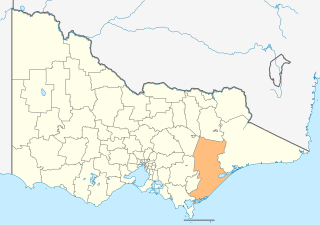
The Shire of Wellington is a local government area in Victoria, Australia, located in the eastern part of the state. It covers an area of 10,817 square kilometres (4,176 sq mi) and in June 2018 had a population of 44,019.

The Division of McMillan was an Australian Electoral Division in the state of Victoria. It was located in the western part of the Gippsland region, which extends for the length of Victoria's eastern Bass Strait coastline. It included the outer south-eastern Melbourne suburb of Pakenham, and also included the towns of Warragul, Moe, Wonthaggi, Leongatha and Foster. It stretched from Mount Baw Baw and the Baw Baw National Park in the north to Wilsons Promontory, and the Wilsons Promontory National Park in the south. It was the southernmost electoral division in continental Australia. It was replaced by the Division of Monash in 2019.
West Sale Airport is located about 5 nautical miles west of Sale, Victoria, Australia, off the Princes Highway.
Stony Creek was a railway station on the South Gippsland line in South Gippsland, Victoria. The station was opened during the 1890s and operated until the 1970s. The line was closed in 1991 and turned into the Great Southern Rail Trail.
Buffalo was a railway station on the South Gippsland line in South Gippsland, Victoria. The station was opened during the 1890s and operated until 1981 when the line to Barry Beach servicing the oil fields in Bass Strait was closed. The line was then dismantled and turned into the Great Southern Rail Trail. All that remains at Buffalo is a Pivot Shed, platform mound and a buffer stop. The line to Barry Beach was later dismantled in 1994 and turned into the Great Southern Rail Trail, to Foster.

Fish Creek was a railway station on the South Gippsland line in South Gippsland, Victoria. The station was opened during the 1890s and operated until 1992 when the line to Barry Beach servicing the oil fields in Bass Strait was closed. The line was then dismantled and turned into the Great Southern Rail Trail. Fish Creek contained a rather extensive goods yard, all of which now has been demolished. The remaining platform is still in good condition.
Hoddle was a railway station on the South Gippsland line in South Gippsland, Victoria. The station was opened during the 1890s and was one of the first to close on the South Gippsland line, closing in the 1960s.
Foster was a railway station on the South Gippsland line in South Gippsland, Victoria, Australia. The station was opened during the 1890s operated until 1992 when the line to Barry Beach servicing the oil fields in Bass Strait was closed. The line was dismantled and turned into the Great Southern Rail Trail.
Hedley was a railway station on the South Gippsland line in South Gippsland, Victoria. The station was opened during the 1890s, and operated until its closure on 31 July 1976.
Gelliondale was a railway station on the South Gippsland line in South Gippsland, Victoria. The station was opened during the 1890s and operated until the 1970s.
Alberton was a railway station on the South Gippsland line, which originally terminated at Port Albert in South Gippsland, Victoria. The station was opened on 13 January 1892, and closed on 6 June 1981. Alberton was the junction for the extension of the South Gippsland line to Woodside in the early 1920s. The line between Alberton and Port Albert closed in the 1940s.
Port Albert was the original terminus station on the South Gippsland railway line, the railway opening to that station on 13 January 1892.

Life FM is a community Christian radio station in the Victorian region of Gippsland. It first went air in the early hours of 29 October 2003. The station broadcasts on the FM band at 103.9 MHz from Mt. Tassie near Traralgon. The Life FM studio and office is based in Sale. 3GCB broadcasts a variety of uplifting and family-friendly music and messages to encourage and inspire the region's Christian audience.
The Diocese of Gippsland is a diocese of the Anglican Church of Australia, founded in 1902. It is situated in the Gippsland region of the state of Victoria, Australia and covers most of the eastern part of the state. The diocesan cathedral is St Paul's Cathedral, Sale. The current Bishop of Gippsland, installed on 18 August 2018, is Richard Treloar.

The electoral district of Gippsland South is a Lower House electoral district of the Victorian Parliament. It is located within the Eastern Victoria Region of the Legislative Council.

The Shire of Alberton was a local government area about 220 kilometres (137 mi) southeast of Melbourne, the state capital of Victoria, Australia. The shire covered an area of 1,868.83 square kilometres (721.6 sq mi), and existed from 1855 until 1994.
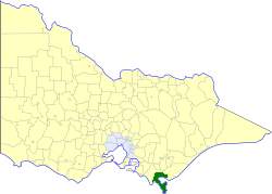
The Shire of South Gippsland was a local government area about 170 kilometres (106 mi) south-southeast of Melbourne, the state capital of Victoria, Australia. The shire covered an area of 1,432.26 square kilometres (553.0 sq mi), and existed from 1894 until 1994.
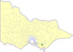
The Shire of Mirboo was a local government area about 160 kilometres (99 mi) southeast of Melbourne, the state capital of Victoria, Australia. The shire covered an area of 255.07 square kilometres (98.5 sq mi), and existed from 1894 until 1994.


