
Guadalupe County is a county located in the U.S. state of Texas. As of the 2020 census, its population was 172,706. The county seat is Seguin. The county was founded in 1846 and is named after Guadalupe River.

Brewster County is a county located in the U.S. state of Texas. It is in West Texas and its county seat is Alpine. It is one of the nine counties that comprise the Trans-Pecos region, and borders Mexico. Brewster County is the largest county by area in the state - at 6,192 square miles (16,040 km2) it is over three times the size of the state of Delaware, and more than 500 square miles (1,300 km2) bigger than Connecticut.
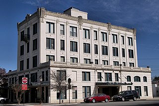
Seguin is a city in and the county seat of Guadalupe County, Texas, United States; as of the 2020 census, its population was 29,433. Its economy is primarily supported by a regional hospital, as well as the Schertz-Seguin Local Government Corporation water-utility, that supplies the surrounding Greater San Antonio areas from nearby aquifers as far as Gonzales County. Several dams in the surrounding area are governed by the main offices of the Guadalupe-Blanco River Authority, headquartered in downtown Seguin.

Floresville is a city in Wilson County, Texas, United States. According to the U.S. Census Bureau, its population was at 7,203 at the 2020 Census. It is the county seat of Wilson County. The city is also part of the San Antonio metropolitan statistical area.
Prairie Chapel Ranch, nicknamed Bush Ranch, is a 1,583-acre (6.41 km2) ranch in unincorporated McLennan County, Texas, located 7 miles (11 km) northwest of Crawford. The property was acquired by George W. Bush in 1999 and was known as the Western White House during his presidency. Bush spent vacation time at the house, where he also entertained visiting dignitaries from around the world. The ranch received its name from the Prairie Chapel School which was built nearby on land donated by mid-19th century German immigrant Heinrich Engelbrecht from Oppenwehe, Germany, who owned the land that now comprises the Bush ranch. Engelbrecht also donated land for the nearby Canaan Baptist Church.

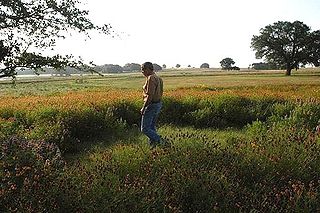
The Texas Hill Country is a geographic region of Central and South Texas, forming the southeast part of the Edwards Plateau. Given its location, climate, terrain, and vegetation, the Hill Country can be considered the border between the American Southeast and Southwest. The region represents the very remote rural countryside of Central Texas, but also is home to growing suburban neighborhoods and affluent retirement communities.
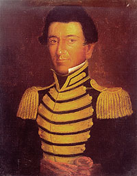
Juan Nepomuceno Seguín was a Spanish-Tejano political and military figure of the Texas Revolution who helped to establish the independence of Texas. Numerous places and institutions are named in his honor, including the county seat of Seguin in Guadalupe County, the Juan N. Seguin Memorial Interchange in Houston, Juan Seguin Monument in Seguin, World War II Liberty Ship SS Juan N. Seguin, Seguin High School in Arlington.

José Antonio Navarro was a Texas statesman, revolutionary, rancher, and merchant. The son of Ángel Navarro and Josefa María Ruiz y Peña, he was born into a distinguished noble family at San Antonio de Béxar in the Viceroyalty of New Spain. His uncle was José Francisco Ruiz and his brother-in-law was Juan Martín de Veramendi.

State Highway 71 is a Texas state highway that runs 253 miles (407 km). The northern terminus is at US 87 and US 377 south of Brady and its southern terminus is at SH 35 near Blessing. This highway is designated the "10th Mountain Division Highway" from SH 95 to Interstate 35.

The Glen Rose Formation is a shallow marine to shoreline geological formation from the lower Cretaceous period exposed over a large area from South Central to North Central Texas. The formation is most widely known for the dinosaur footprints and trackways found in the Dinosaur Valley State Park near the town of Glen Rose, Texas, southwest of Fort Worth and at other localities in Central Texas.

TSTC Waco Airport is a public use airport located eight nautical miles northeast of the central business district of Waco, a city in McLennan County, Texas, United States. Before 1968, it was known as James Connally Air Force Base. The airport is owned by Texas State Technical College. It is included in the National Plan of Integrated Airport Systems for 2021–2025, which categorized it as a general aviation facility.
Juan José María Erasmo de Jesús Seguín y Fuentes was a prominent citizen and politician in San Antonio de Bexar in the 19th century. From 1807 until 1835, Seguín served as head postmaster of San Antonio, Texas. After Mexico achieved independence from Spain, Seguín was named the sole representative from Texas to the constitutional convention. He helped to draft the Constitution of 1824 and was a major influence in the addition of a general colonization provision. Seguín assisted Stephen F. Austin in choosing land for the first colony of American settlers to immigrate to Texas. He later supported the Texas Revolution, providing political as well as material support. He was the father of Tejano revolutionary Juan Seguín.
Lakeway Airpark is a public use airport in Travis County, Texas, United States. The airport is 17 nautical miles west of the central business district of Austin. It is privately owned by Lakeway Airpark, Inc. and is located in Lakeway, Texas.

Leesville is an unincorporated city of 384 residents distributed over 51 square miles in the Gonzales—Guadalupe County area in Texas, United States, electorally known as local Precinct 13; defined by the south of its Capote Hills at the "Leesville Quad" intersection and the north of Sandies Creek, twelve miles southeast of Seguin. Beginning in the 19th century, the municipal identity of Leesville was founded upon being one of the first Justice of the Peace Precincts of its original county-area, as prescribed in the Texas Constitution; as well as once generally serving as the primary seat of a former Texas House District 90, once rated at more than 1,000 constituents. Straddling and nearing the southeastern border of Guadalupe County, the real estate origins of Leesville go back to the 1800s survey-plots of Texas Revolution figures Ezekiel Wimberly Cullen and Count Joseph de la Baume of France ; the latter retaining Texas's founding father Stephen F. Austin as an attorney, to reacquire the early-1800s Spanish land-tract, after Mexico's Independence from Spain in 1825. Divided by Farm to Market Road 1682 joining with Gonzales—Guadalupe County Road 121 West, Leesville's northern territory is closest to the Austin Metropolitan Areas through Texas State Highway 80 / U.S. Route 183 in Texas, while the southern territory is closest to the San Antonio Metropolitan Areas through Texas State Highway 97 / U.S. Route 87 in Texas.
Salvador Flores served as a volunteer in the Texan Army in 1835–1836. He was instrumental in organizing and commanding Texian volunteers in support of the Texas Revolution. He participated in many battles and would rise through the ranks to reach Captain status during the fight for Texas independence from Mexico. Salvador continued to provide protection for the ranches and settlers of Texas throughout the Republic years.

Manuel Flores served as a volunteer in the Texas army in 1835–1838. Fighting and commanding, he rose through the ranks to reach sergeant status during the fight for Texas independence and was commissioned a captain during the Republic years.
Pronger Bros. Ranch Airport is a privately owned, public use airport located eight nautical miles southwest of the central business district of Stratford, in Sherman County, Texas, United States.
Lesikar Ranch Airport is a privately owned, public use airport located seven nautical miles east of the central business district of Hallettsville, a city in Lavaca County, Texas, United States.
Cluck Ranch Airport is a privately owned, public use airport in Sherman County, Texas, United States. It is located 17 nautical miles southwest of the central business district of Gruver, a city in Hansford County.
Lazy G Bar Ranch Airport is a privately owned public airport in Decatur, Wise County, Texas, United States, located approximately 5 nautical miles (9.3 km) northeast of the central business district. The airport has no IATA or ICAO designation.
