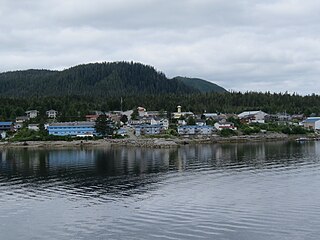
Bella Bella, also known as Waglisla, is the home of the Heiltsuk and is an unincorporated community and Indian reserve community located within Bella Bella Indian Reserve No. 1 on the east coast of Campbell Island in the Central Coast region of British Columbia, Canada. Bella Bella is located 98 nautical miles (181 km) north of Port Hardy, on Vancouver Island, and 78 nautical miles (144 km) west of Bella Coola. The community is on Lama Passage, part of the Inside Passage – a transportation route linking the area, and northern British Columbia as well as Alaska for marine vessels carrying cargo, passengers and recreational boaters from the south coast. The settlement "forms a national capital of sorts" to the Heiltsuk.
Kingcome Inlet is one of the lesser principal fjords of the British Columbia Coast, north and east of Broughton Island. It is sixth in sequence of the major saltwater fjords north from the 49th parallel near Vancouver and similar in width, on average 2.5 km (1.6 mi), to longer inlets such as Knight Inlet and Bute Inlet, but it is only 35 km (22 mi) in length from the mouth of the Kingcome River to Sutlej Channel, which ultimately connects around Broughton Island to the main regional waterway of the Queen Charlotte Strait. Kingcome Inlet has a short side inlet, Wakeman Sound, fed by the Wakeman River.
Telegraph Cove is a community of about 20 inhabitants, on Vancouver Island in British Columbia, Canada, located approximately 210 kilometres (130 mi) northwest of Campbell River. It is a former fishing and cannery village that has become a launch point for eco-tourism. It shares the inlet with Beaver Cove which is 3 km (2 mi) up the inlet.

Valdes Island is one of the Gulf Islands located in the Strait of Georgia, British Columbia, Canada. It is across Porlier Pass from Galiano Island, which lies to the southeast. It has an area of 23 square kilometres, and is 1.6 kilometres wide by 16 kilometres in length. The island is popular with kayakers, boaters and has historically been the site of several human settlements.
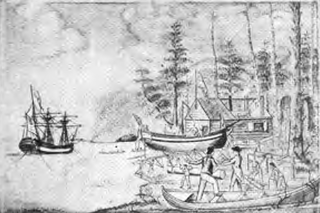
Fort Defiance was a small outpost that the crew of the Columbia Rediviva built as winter quarters during 1791–1792 on Meares Island in present-day British Columbia, Canada. American merchant and maritime fur trader Captain Robert Gray was in command.

Porcher Island is an island in Hecate Strait, British Columbia, Canada, near the mouth of the Skeena River and southwest of the port city of Prince Rupert. The locality of Porcher Island is located near the island's northern tip at Humpback Bay, 54°05′11″N130°23′23″W. Stephens and Prescott Islands are located off its northwestern tip.
The ƛoʔos Klahoose are one of the three groups comprising the ʔayʔaǰuθəm Tla'Amin or Mainland Comox. The other two divisions of this once-populous group are the χʷɛmaɬku Homalco and Sliammon. The Klahoose, Homalco and Sliammon are, according to oral tradition, the descendants of the survivors of the Great Flood. The three groups were split by colonialism into different band councils but united historically as the Tla A'min, known as the Mainland Comox, and K’ómoks, the larger grouping of the Comox people, also known as the Island Comox and before the merger with the Laich-kwil-tach culture. Historically both groups are a subgroup of the Coast Salish though the K’ómoks name is from, and their language today, is the Lik'wala dialect of Kwak'wala. The ancestral tongue is the Comox language, though the Sahtloot/Island dialect is extinct.
Kingcome, also known as Okwunalis or Ukwana'lis is an unincorporated settlement in the Kingcome Inlet area of the Central Coast of British Columbia, Canada, located a few miles up the Kingcome River from the head of the inlet. Quaee Indian Reserve No. 7 is the Indian reserve containing the village.
Longview was a cannery town on the South Coast of British Columbia, Canada, located near Langdale and Port Mellon on the west, mainland side of Thornbrough Channel, a side-channel of Howe Sound separating Gambier Island from the mainland Sunshine Coast. Another cannery town on the same bit of coast was just south, at Seaside Park.
Boswell was a cannery town in the Central Coast region of the South Coast of British Columbia, Canada, located on the north side of Boswell Inlet, an arm of Smith Sound.
Redonda Bay is an uninhabited locality that was the site of a cannery owned by Francis Millerd & Co., located on the northwest side of West Redonda Island in the Discovery Islands of the South Coast of British Columbia, Canada.
Observatory Inlet is an inlet on the North Coast of British Columbia. It is a northward extension of Portland Inlet, other branches of which include the Portland Canal. The entrance of Observatory Inlet, from Portland Inlet, lies between Ramsden Point and Nass Point. Ramsden Point also marks, to the west, the entrance of Portland Canal. Observatory Inlet was named by George Vancouver in 1793, because he set up his observatory on the shore of the inlet, at Salmon Cove, in order to calibrate his chronometers. His two vessels, HMS Discovery and HMS Chatham, stayed in Salmon Cove from July 23 to August 17, 1793. During this time a boat surveying expedition under Vancouver himself explored Behm Canal. Vancouver also named three headlands at the entrance of Observatory Inlet: Maskelyne Point, for Nevil Maskelyne, the Astronomer Royal, Wales Point, for William Wales, the mathematical master who sailed with James Cook, and Ramsden Point, after the famed mathematical instrument-maker Jesse Ramsden.

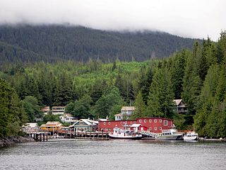
Old Bella Bella, also known as Old Towns or Qlts, was the name for the Heiltsuk village that grew up around the Hudson's Bay Company's historic Fort McLoughlin, at McLoughlin Bay on Campbell Island. The village relocated to the present site of Bella Bella, British Columbia by 1903. Today the Heiltsuk control the site, which houses a BC Ferries terminal, fish plant, and two houses, as well as archaeological remains of the old village.
Silver River was a logging camp on the east side of Harrison Lake in British Columbia, Canada, located at the mouth of Big Silver Creek, which is also unofficially called the Silver River or Big Silver River.
Bones Bay is located inside the territorial properties of the Namgiis indigenous peoples on a bay the north side of West Cracroft Island in the Johnstone Strait region of the Central Coast of British Columbia, Canada, on Clio Channel.
Kildonan is an unincorporated community in the Alberni Inlet-Barkley Sound region of the west coast of southern Vancouver Island, British Columbia. The former steamboat landing and ferry dock is on the east shore of Uchuchklesit Inlet, which branches northwest of the lower reaches of Alberni Inlet. Adjacent to Pacific Rim National Park Reserve, the locality is by road and ferry about 120 kilometres (75 mi) southwest of Port Alberni.

Checleset Bay is a bay on the northwest coast of Vancouver Island, British Columbia, Canada. It is located southeast of Brooks Peninsula and northwest of Kyuquot Sound. Much of the land around the bay is part of Brooks Peninsula Provincial Park. Checleset Bay has three large inlets, Nasparti Inlet, Ououkinsh Inlet, and Malksope Inlet.
